Rannstedt
| coat of arms | Germany map | |
|---|---|---|
 Help on coat of arms |
Coordinates: 51 ° 5 ' N , 11 ° 32' E |
|
| Basic data | ||
| State : | Thuringia | |
| County : | Weimar Country | |
| Fulfilling municipality : | Bad Sulza | |
| Height : | 198 m above sea level NHN | |
| Area : | 2.96 km 2 | |
| Residents: | 178 (Dec. 31, 2019) | |
| Population density : | 60 inhabitants per km 2 | |
| Postal code : | 99518 | |
| Area code : | 036463 | |
| License plate : | AP, APD | |
| Community key : | 16 0 71 077 | |
| Address of the municipal administration: |
Dorfstrasse 21 99518 Rannstedt, Germany |
|
| Website : | ||
| Mayor : | Horst Krocker | |
| Location of the municipality of Rannstedt in the Weimarer Land district | ||
Rannstedt is a municipality in the northeast of the Weimarer Land district . The fulfilling municipality is the city of Bad Sulza .
location
Rannstedt is located directly on the federal highway 87 about five kilometers before Eckartsberga just before the state border with Saxony-Anhalt in an arable area around Apolda .
history
The village was first mentioned between 822 and 842.
In the years 1446 to 1451 the place was destroyed in the Saxon fratricidal war. In 1497 47 adult residents in 20 households were named in the state tax register. A large fire destroyed large parts of the town in 1712, and in 1735 there were 37 houses, a church, a school, an inn with a post office and a brewery and bakery.
In the past, Rannstedt reflected the fragmentation of Thuringia. While the corridor of the place with the neighboring Ködderitzsch formed an exclave of the Eckartsberga office belonging to the Electorate of Saxony , the place itself belonged to the Ernestine office Roßla , which came to Sachsen-Weimar when the line Sachsen-Altenburg died out in 1672 and since 1741 Saxony-Weimar-Eisenach belonged. Due to the resolutions of the Congress of Vienna in 1815, the Rannstedts corridor also became part of Sachsen-Weimar-Eisenach. It was affiliated with the Roßla office. During the administrative reform of the Grand Duchy of Saxony-Weimar-Eisenach, Rannstedt came to the administrative district of Weimar II and legally to the Apolda Justice Office in 1850 . The place has belonged to Thuringia since 1920.
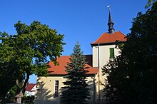
The church , built in 1716, was completely restored in 1994 and the steeple was rebuilt.
In 1900 Rannstedt was connected to the telephone network, electricity followed in 1908, a central water supply in 1969 and natural gas supply in 1995.
The current mayor (as of 2018) is Horst Krocker.
Personalities
- Karl Krehahn (1869–1946), musician and music teacher
Web links
- Rannstedt on the website of the city of Bad Sulza
Individual evidence
- ^ Population of the municipalities from the Thuringian State Office for Statistics ( help on this ).
- ^ Wolfgang Kahl : First mention of Thuringian towns and villages. A manual. 5th, improved and considerably enlarged edition. Rockstuhl, Bad Langensalza 2010, ISBN 978-3-86777-202-0 , p. 227.
- ^ Johann Ernst Fabri : Geography for all estates. Part 1, Volume 4: Which contains the continuation and the resolution of the Upper Saxon Circle. Schwickert, Leipzig 1793, p. 35 f.
- ↑ Geographical overview of the Saxon-Ernestine, Schwarzburg, Reussian and adjacent lands. Perthes, Gotha 1826, p. 55 f.
- ^ Apolda district court district. In: Paul Lehfeldt : Architectural and art monuments of Thuringia. Grand Duchy of Saxony-Weimar-Eisenach. Volume 2 = Issue 1 and 13/14: Apolda administrative district. District court districts Jena, Allstedt, Apolda and Buttstädt. Gustav Fischer, Jena 1892, p. 307 ff.


