Ballstedt
| coat of arms | Germany map | |
|---|---|---|

|
Coordinates: 51 ° 3 ' N , 11 ° 13' E |
|
| Basic data | ||
| State : | Thuringia | |
| County : | Weimar Country | |
| Fulfilling municipality : | At the Ettersberg | |
| Height : | 238 m above sea level NHN | |
| Area : | 3.36 km 2 | |
| Residents: | 279 (Dec. 31, 2019) | |
| Population density : | 83 inhabitants per km 2 | |
| Postal code : | 99439 | |
| Area code : | 036452 | |
| License plate : | AP, APD | |
| Community key : | 16 0 71 005 | |
| LOCODE : | DE BO5 | |
| Address of the municipal administration: |
Hauptstrasse 23 99439 OT Berlstedt municipality Am Ettersberg |
|
| Mayor : | Joachim Pommeranz | |
| Location of the municipality of Ballstedt in the Weimarer Land district | ||
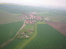
Ballstedt is a municipality in the north of the Weimarer Land district in Thuringia. Since January 1, 2019, the fulfilling municipality has been the rural municipality Am Ettersberg .
location
Ballstedt is located southwest of the core municipality Berlstedt on the southern edge of the Thuringian Basin at the foot of the northwestern roof of the Großer Ettersberg and in its rain shadow. The Wolfsbach flows through the village. It is dammed northeast of Ballstedt in the Vippachedelhausen dam . The corridor of the village is laid out due to the natural conditions and is also used to feed the population.
history
The first secure mention of the place Ballstedt took place on April 24, 1256 in the deed book of the Erfurt monasteries and monasteries. In an earlier mention around 900 in the property book of the Fulda monastery as Boldolfstete, it is not certain whether Ballstedt or Ballstädt near Gotha is meant. The latter, however, was referred to as Baldenstedt in another document. The place name changed from Baldinstete, Baldestet to Ballstedt. Two estates measuring 70 hectares and 25 hectares in size have been detectable since the Middle Ages. In the 18th century these were incorporated into the Bachstedt Chamber Estate .
Due to its location on the Via Regia , the place gained some importance. However, the proximity to this military road led to destruction and looting in the event of war. Imperial troops burned the place down completely in 1636/1637 during the Thirty Years' War . In 1640 the number of inhabitants decreased as a result of the war. Only five families were counted, 32 houses were empty. Between 1806 and 1813 there was again destruction in the course of the coalition wars . Agriculture was the main source of income for the place. There is evidence of woad cultivation from the 16th century . In 1533 a school was founded in Ballstedt. Today the children attend school in Berlstedt. In 1811 Ballstedt came to the Weimar Office as an administrative village . In 1922 the district of Weimar was formed, to which Ballstedt belonged until it was merged with the district of Weimarer Land. Until January 1, 2019, the village was part of the administrative community of Northern Weimar .
Attractions
Church and churchyard were added to the monuments list of the Weimarer Land district.
The church was built in late Gothic style around 1500 . In 1637 it burned out completely as a result of the war. The reconstruction did not take place until 1700–1701, as the place only slowly recovered from the consequences of the Thirty Years' War. In 1988 a renovation took place. Between 1999 and 2001 the church was completely renovated and restored. Inside, two damaged tombstones from the 16th and 17th centuries have been preserved.
Personalities
- Tobias Kiel (born October 29, 1584 in Ballstedt, † 1627), spiritual poet and playwright
- Siegfried Baumbach (born July 6, 1907 in Ballstedt, † August 25, 1981 in Hamburg), astrophysicist, astronomer, meteorologist and university professor
Individual evidence
- ^ Population of the municipalities from the Thuringian State Office for Statistics ( help on this ).


