
Wiegendorf
| coat of arms | Germany map | |
|---|---|---|

|
Coordinates: 50 ° 59 ' N , 11 ° 26' E |
|
| Basic data | ||
| State : | Thuringia | |
| County : | Weimar Country | |
| Management Community : | Mellingen | |
| Height : | 260 m above sea level NHN | |
| Area : | 4.04 km 2 | |
| Residents: | 340 (Dec. 31, 2019) | |
| Population density : | 84 inhabitants per km 2 | |
| Postal code : | 99510 | |
| Area code : | 036462 | |
| License plate : | AP, APD | |
| Community key : | 16 0 71 095 | |
| Association administration address: | Karl-Alexander-Str. 134a 99441 Mellingen |
|
| Mayor : | Sven Hofmann | |
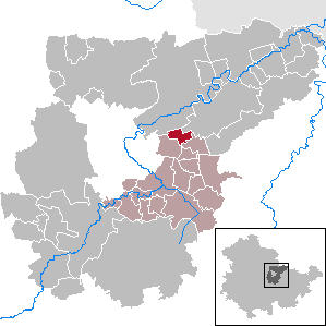
| Location of the community of Wiegendorf in the Weimarer Land district | ||
  |
||

Wiegendorf is a municipality in the south of the Weimarer Land district and part of the Mellingen administrative community . The district of Schwabsdorf belongs to the municipality of Wiegendorf .
geography
Wiegendorf lies at the beginning of the valley of the Wiegendorfer Bach, which leaves the place in a north-easterly direction. The village is one kilometer south of the federal highway 87 and surrounded by arable land.
history
The first mention of the place Wiegendorf took place in 1216 in a document of the burgrave Dietrich von Kirchberg . At the same time a noble family von Wiegendorf was mentioned. In the Thirty Years War , the place was largely devastated. Due to its location on a trade route, an inn was built in the 18th century. From the beginning of the 19th century, the place was part of the Grand Duchy of Saxony-Weimar-Eisenach and after 1945 with the state of Thuringia became part of the Soviet occupation zone and the GDR . On April 1, 1974, the neighboring town of Schwabsdorf became a district of Wiegendorf. The municipality has belonged to the state of Thuringia since 1990.
At the end of May / beginning of June 2017, the place was hit several times within a few days by storms with heavy rain and the location was flooded several times.
Personalities
- Gotthard Arno Ernst Neumann (1902–1972) German prehistoric professor and professor of prehistory
Attractions
The following buildings are under monument protection:
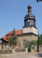
- Church in Wiegendorf with churchyard
- Church in the Schwabsdorf district
- Prussian milestone on the B87 in the direction of Umpferstedt
Evangelical village church Schwabsdorf (2010)

Evangelical village church Wiegendorf (2010)


Companies
- Eurolam GmbH since January 24, 1997, founded by Ernst Hommer.
Individual evidence
- ^ Population of the municipalities from the Thuringian State Office for Statistics ( help on this ).
- ↑ Jens Lehnert: Wiegendorf flooded for the third time within 15 days , Thüringer Allgemeine , June 3, 2017
- ↑ Eurolam company website ( Memento of August 28, 2013 in the Internet Archive ) Retrieved on April 5, 2012
Web links
At Ettersberg | Apolda | Bad Berka | Bad Sulza | Ballstedt | Blankenhain | Buchfart | Dobrich | Eberstedt | Ettersburg | Frankendorf | Grammetal | Big herring | Großschwabhausen | Hammerstedt | Hetschburg | Hohenfelden | Ilmtal Wine Route | Kapellendorf | Kiliansroda | Kleinschwabhausen | Klettbach | Crane field | Lehnstedt | Magdala | Mechelroda | Mellingen | Nauendorf | Neumark | Niedertrebra | Obertrebra | Oetter | Rannstedt | Rittersdorf | Blacksmiths | Tonndorf | Umpferstedt | Vollersroda | Wiegendorf