Umpferstedt
| coat of arms | Germany map | |
|---|---|---|

|
Coordinates: 50 ° 59 ′ N , 11 ° 25 ′ E |
|
| Basic data | ||
| State : | Thuringia | |
| County : | Weimar Country | |
| Management Community : | Mellingen | |
| Height : | 270 m above sea level NHN | |
| Area : | 7.4 km 2 | |
| Residents: | 631 (Dec. 31, 2019) | |
| Population density : | 85 inhabitants per km 2 | |
| Postal code : | 99441 | |
| Area code : | 03643 | |
| License plate : | AP, APD | |
| Community key : | 16 0 71 089 | |
| LOCODE : | DE UFT | |
| Association administration address: | Karl-Alexander-Str. 134a 99441 Mellingen |
|
| Website : | ||
| Mayor : | Jürgen Vogel | |
| Location of the municipality Umpferstedt in the Weimarer Land district | ||
Umpferstedt is a municipality in the south of the Weimarer Land district and part of the Mellingen administrative community in Thuringia .
location
Umpferstedt is located in the Thuringian Basin on an arable site between Apolda and Weimar . In the place the federal roads 7 and 87 cross with connection to the federal highway 4 near Mellingen .
history
Vnfridesstat was first mentioned in a document between 780 and 802 in connection with a donation to the Fulda monastery . However, since no precise date is given or can be determined, the document issued on May 18, 876 on the tithing dispute between the Archbishop of Mainz and the Abbot of Fulda is the first mention of Umpferstedt. Around 900 the writing Unfridestat can be proven in a deed of donations from Thuringians to the Fulda monastery. On March 12, 1364 Umpferstedt was given as a gift to the Oberweimar monastery . The place was ravaged by the plague several times , for example in 1597, 1611 and 1636. During the Thirty Years War , the place was plundered twice. The first looting took place in 1640 by Swedish troops. After the second looting, the place was set on fire. The subsequent major fire destroyed 54 of the 83 houses. The population fell to 118 people.
From the beginning of the 19th century, the place was part of the Grand Duchy of Saxony-Weimar-Eisenach and after 1945 with the state of Thuringia became part of the Soviet occupation zone and the GDR . The consequences were, among other things, expropriations of large-scale farming property, families fleeing to West Germany and forced collectivization.
Since 1990 the place belongs to the newly founded state of Thuringia. Tensions in Umpferstedt arose after the partial transfer of properties back to the previous owners.
After 1990, the Jehovah's Witness community built a Kingdom Hall on the business park on the B87 .
Personalities
- Wolfgang Büttner (1520 or 1524–1576), pastor and poet
Attractions
The following objects are under monument protection :
- Church with churchyard:
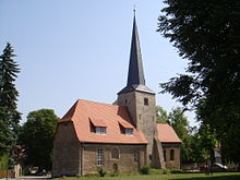
- A first church can be found in the village as early as 1300. In 1326 the parish was first mentioned in a document. In the 16th century the church tower was built in its current pointed shape. One bell dates from 1580.
- Memorial for 11 unknown concentration camp prisoners, parking lot on the B 7 and
- Grave site for 11 unknown concentration camp prisoners, cemetery:
- On April 7, 1945, 11 prisoners from the Buchenwald concentration camp near Umpferstedt were murdered and then buried in the cemetery. (see also: end-of-war crimes )
- Prussian milestone , B 7 towards Frankendorf
- Rectory and wall, church square
- Taubenturm, town center
Also noteworthy:
- Memorial for the participants in the Franco-Prussian War 1870/71 from the village
- Memorial to soldiers killed and missing in World War I: in front of the church
- Bizarre old linden tree trunk next to the church
literature
- Axel Marx: family book Umpferstedt. (Weimarer Land district), Thuringia. 2 volumes. Working Group for Central German Family Research, Leipzig 2010–2011;
- Volume 1: 1252–1800 (= Central German local family books of the AMF. 56, ZDB -ID 2385367-0 = German local family books. Series B, 494). 2010;
- Volume 2: born 1801 to 1900, ⚭ 1801 to 1930, died 1801 to 1980 (= Central German local family books of the AMF. 62 = German local family books. Series B, 597). 2011.
Individual evidence
- ^ Population of the municipalities from the Thuringian State Office for Statistics ( help on this ).
- ↑ Sabine Brandt: Back after twenty years: the wall. In Umpferstedt, there is a cold war between old owners who have moved in and their neighbors - and slowly it threatens to get hot. In: Thüringische Landeszeitung , 11 November 2009.


