
Vollersroda
| coat of arms | Germany map | |
|---|---|---|

|
Coordinates: 50 ° 56 ' N , 11 ° 20' E |
|
| Basic data | ||
| State : | Thuringia | |
| County : | Weimar Country | |
| Management Community : | Mellingen | |
| Height : | 342 m above sea level NHN | |
| Area : | 2.59 km 2 | |
| Residents: | 210 (Dec. 31, 2019) | |
| Population density : | 81 inhabitants per km 2 | |
| Postal code : | 99438 | |
| Area code : | 03643 | |
| License plate : | AP, APD | |
| Community key : | 16 0 71 093 | |
| Association administration address: | Karl-Alexander-Str. 134a 99441 Mellingen |
|
| Website : | ||
| Mayoress : | Sabine Seyfarth (since July 2010) | |
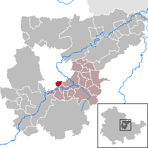
| Location of the community Vollersroda in the Weimarer Land district | ||
  |
||

Vollersroda is a municipality in the south of the Weimarer Land district and part of the Mellingen administrative community .
history
In 1262 the place Vollersroda was first mentioned in a document from Volrad von Kranichfeld for the monastery of Oberweimar as "Volradshrode".
The lords of Schleidnitz and von Lichtenberg owned goods and rights in Voylesrode in the 14th century . Later the place came into the possession of the Counts of Weimar-Orlamünde and from 1428 belonged to the Counts of Schwarzburg . In the years 1440 and 1508 there were other mentions of the place. In the Saxon Brotherly War (1446 to 1451) the place was completely destroyed and declared a desert. In 1598 the place was sold by the Saxon Chancellor Marcus Gerstenbergk to Duke Friedrich Wilhelm of Saxe-Weimar . Vollersroda survived the Thirty Years' War tolerably, while the Weiheroda settlement about 500 m to the east was destroyed. From the beginning of the 19th century, the place was part of the Grand Duchy of Saxony-Weimar-Eisenach , district court district Jena and after 1945 became part of the Soviet occupation zone and the GDR with the state of Thuringia . Since 1990 the place belongs to the newly founded state of Thuringia.
Attractions
- The village's → village church from the 18th century has a choir tower with a half-timbered tower that is characterized as “defensive” and has been included in the monuments list of the Weimarer Land district. It was also painted several times by Lyonel Feininger .
- On the way to the guard hill you come across the horse pond - a natural, water-filled depression in the hallway of the village. According to a legend, this was a resting place for carters, who always had to give their horses and themselves a break after having passed the Buchfahrter Berg before they could reach the village.
literature
- Thuringian Open Air Museum Hohenfelden (Ed.): On the way in the Ilm valley. Interesting facts and information for tourists and locals . MFB-Verlagsgesellschaft, Eisenach 1998, ISBN 3-931431-10-X , Vollersroda, p. 46 .

Church in Vollersroda

Information board for the Feininger cycle path in Vollersroda

War memorial in Vollersroda in front of the church


Individual evidence
- ^ Population of the municipalities from the Thuringian State Office for Statistics ( help on this ).
- ↑ Jonathan Carl Zenker : Historical-topographical pocket book of Jena and its surroundings, especially in natural science and medical relationship. With the plan from Jena and a geognostic profile. Frommann, Jena 1836, p. 149 .
- ^ Jürgen Postel: Calendar "Weimarer Land" . Gutenberg-Druckerei, Weimar 2001, The horse pond near Vollersroda.
Web links
At Ettersberg | Apolda | Bad Berka | Bad Sulza | Ballstedt | Blankenhain | Buchfart | Dobrich | Eberstedt | Ettersburg | Frankendorf | Grammetal | Big herring | Großschwabhausen | Hammerstedt | Hetschburg | Hohenfelden | Ilmtal Wine Route | Kapellendorf | Kiliansroda | Kleinschwabhausen | Klettbach | Crane field | Lehnstedt | Magdala | Mechelroda | Mellingen | Nauendorf | Neumark | Niedertrebra | Obertrebra | Oetter | Rannstedt | Rittersdorf | Blacksmiths | Tonndorf | Umpferstedt | Vollersroda | Wiegendorf