
Mellingen (Thuringia)
| coat of arms | Germany map | |
|---|---|---|

|
Coordinates: 50 ° 57 ' N , 11 ° 24' E |
|
| Basic data | ||
| State : | Thuringia | |
| County : | Weimar Country | |
| Management Community : | Mellingen | |
| Height : | 230 m above sea level NHN | |
| Area : | 14.42 km 2 | |
| Residents: | 1425 (Dec. 31, 2019) | |
| Population density : | 99 inhabitants per km 2 | |
| Postal code : | 99441 | |
| Area code : | 036453 | |
| License plate : | AP, APD | |
| Community key : | 16 0 71 056 | |
| Association administration address: | At the Malzdarre 1 99441 Mellingen |
|
| Website : | ||
| Mayor : | Eberhard Hildebrandt ( CDU ) | |
| Location of the community of Mellingen in the Weimarer Land district | ||
  |
||

Mellingen is a municipality in the south of the Weimarer Land district and part of the Mellingen administrative community . Districts are Mellingen and Köttendorf .
geography
Mellingen is divided into a district on the right of the Ilm with the parish church and one on the left of the Ilm, an extension from the High Middle Ages. In Mellingen the Magdel flows into the Ilm.
Mellingen borders the municipalities (clockwise from the north) Umpferstedt , Lehnstedt , Magdala , Mechelroda , OETT , Vollersroda and the city of Weimar .

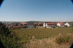
Town center and view of St.Georg

Ilm weir of the lower mill
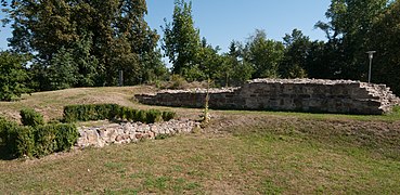
Mellingen Castle


history
The place was first mentioned in 1137 as Meldingen and was once the seat of a castle. There were two castles in Mellingen. The first castle on Kapellenberg was destroyed in 1175. The location of the second castle (Heinrichsburg) is north of the Ilm and east of the village center close to the main road. It probably served to secure the Ilm crossing. The fortress belonged to the influential Lords of Mellingen from the family of Schenken and Vitzthume von Apolda , who named themselves in 1137, 1149 and 1193 after the town of Mellingen. You were in the service of the Archbishops of Mainz . Beringer von Meldingen was one of the many nobles who perished in the fall of the Erfurt latrine in July 1184. In 1250 the family split into the Blankenhain line , which also acquired the county of Berka in 1272. The other branches passed into the lower nobility. Heinrichsburg was given up in 1451 after it was destroyed in the Saxon Brotherly War . The location of the castle is hardly recognizable today.
Mellingen received market rights as early as 1609. Today's parish church was built in 1669 from a medieval choir tower church. From the beginning of the 19th century, the place was part of the Grand Duchy of Saxony-Weimar-Eisenach and after 1945 with the state of Thuringia became part of the Soviet occupation zone and the GDR . Since 1990 the place belongs to the newly founded state of Thuringia.
coat of arms
Today the coat of arms shows a green signal bush on gold. It should represent that of the “von Mellingen” family. Historically, the coat of arms has been misinterpreted. A stylized apple tree can be seen on old family seals. It can be explained if one takes into account that the Lords of Mellingen were a branch of the family of the Lords of Apolda, who first had an apple tree, then a branch with apples or only three apples in the coat of arms.
politics

The municipal council has 12 members. The local elections since 2009 had the following results:
| Parties and constituencies | % 2009 |
Seats 2009 |
% 2014 |
Seats 2014 |
% 2019 |
Seats 2019 |
|---|---|---|---|---|---|---|
| CDU | 56.5 | 7th | 56.3 | 7th | ||
| SPD-WG Mellingen | 43.5 | 5 | 43.7 | 5 | ||
| CDU-SPD-WG Mellingen | 91.2 | 12 | ||||
| total | 100 | 12 | 100 | 12 | ||
| voter turnout | 59.5% | 61.6% | 71.6% | |||
Attractions

On the south-eastern edge of the village, the Feininger Tower was built in 1999 by the Swiss artist and architect Marcel Kalberer as part of a project during Weimar's time as European Capital of Culture . This is also called the double motif and is based on the painting Die Kirche von Mellingen by Lyonel Feininger, painted in 1920 . The original of the picture hangs in the Von der Heydt Museum in Wuppertal . The Feininger cycle path leads past the Feininger tower. The medieval castle Mellingen of the Lords of Mellingen mentioned in 1137 - a protected ground monument - is located on the B87.
Buildings
- Malzdarre: Mayor's office and home parlor
- Old school: current village community center
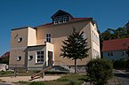
- Old Villa: seat of the administrative association
- Old town center on the Kirchberg with St. Georg church and churchyard
- Building complex of the Untermühle
- Railway bridge over the B 87
- Motorway bridge over the Ilmtal (A-BW 215)
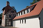
Malt kiln with home parlor and mayor's office
Old school

Seat of the administrative association
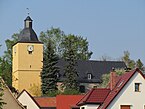
Evangelical Church of St. George


Monuments
- Cemetery with a memorial for the perished soldiers of the First World War in the cemetery and gravesite for six unknown concentration camp prisoners
- Ernst-Thälmann memorial stone between Ernst-Thälmann-Strasse, a newly built area in the GDR, and Bahnhofstrasse
- Memorial for the fallen of 1870/71 below the Kirchberg
Schenkborn
Mellingen development area
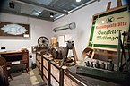
Heimatstube Mellingen

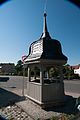
Malt kiln with weir on the Ilm

Anger from Mellingen


Infrastructure and economy
education
kindergarten
The kindergarten on Blankenhainer Straße was reconstructed in 2009. The Erfurt graphic artist Dieter Henning has attached a mural to his gable wall, which reminds of the revival of the Feininger tradition in the village through the annual Feininger Plein air, where hundreds of children are active in painting under the guidance of art teachers.
schools
There is a primary school in the village as well as the neighboring Lyonel-Feininger-Gymnasium . The primary school was built in 1968 and expanded in 1984. Originally it was to be named after the first female cosmonaut, Valentina Tereschkowa . Since the school had very good relationships with the Buchenwald National Memorial, it was given the name POS "Albert Kuntz" Mellingen in 1974 , named after Albert Kuntz , a communist from Wurzen who was in the Lichtenburg , Buchenwald and Mittelbau Dora concentration camps was imprisoned and killed in the Dora concentration camp. A wall mosaic at the primary school still reminds of the originally planned name.

Mural by Dieter Henning at the kindergarten, 2009

Ceramic wall mosaic for Valentina Tereschkowa at the elementary school

Lyonel-Feininger-Gymnasium


traffic
The municipality of Mellingen is located in the middle of the Ilm Valley, directly at the motorway exit 50 Apolda of the federal motorway 4 . The adjacent federal road 87 leads directly to the district town of Apolda , which is about 15 km away. In the opposite direction it leads to Bad Berka and Blankenhain . Landstrasse 2161 connects the Weimarer Land with the independent city of Weimar, which is very easy to reach from Mellingen.

The community has its own stop on the Weimar – Gera railway line , which connects Mellingen with Weimar (5 minutes), Jena (12 minutes), Erfurt (29 minutes) and Gera (54 minutes). Mellingen can be reached every hour during the week by regional train from Weimar or from Jena West / Gera. Regional trains coming from both directions meet here every hour. The stop is located on the northern outskirts of the village, it is about a 10-minute walk to the center. Mellingen can also be reached by bus lines 229, 253 and 255. There are four stops: Weimarstrasse, Burgkeller, elementary school / grammar school and the district of Köttendorf.
The Ilmtal cycle path also leads directly through Mellingen.
economy

Around 100 companies with more than 400 jobs are currently based in Mellingen. Almost a third of this comes from LAYERTEC GmbH, which operates worldwide in the field of optical coatings. On the outskirts, with a direct connection to the autobahn, is the south industrial area with a truck stop and other businesses. In addition, Mellingen owns another industrial area "Am Hammerstedter Weg" on federal road 87.
Along the road 2161 in the direction of Taubach , the community of Mellingen has the residential building area “Between the Villages”, which is to be expanded.
In addition, the place has two doctor's offices, a bakery, a hairdresser and a larger food retailer.
societies
In Mellingen, the SSV Blau-Gelb Mellingen-Taubach 1872 e. V. resident, which has six departments ( soccer , bowling , volleyball , riding , gymnastics , minstrels ).
Personalities
Sons and daughters of the place
- Friedrich Teuscher (1791-1865) was a German Protestant tutor , pastor , superintendent , writer and author .
- Karl Weise (1844–1926), architect and construction clerk of the Grand Duchy of Saxony-Weimar-Eisenach
- Paul Michael (1864–1948), teacher, scientist and geologist
People connected to the place
- Ahasverus Fritsch (1629–1701), composer and lawyer, active in Rudolstadt from 1657, manor owner in Mellingen
- Lyonel Feininger (1871–1956), German-American painter, graphic artist and caricaturist who repeatedly drew Mellingen between 1906 and 1937
literature
- Axel Marx: Family book Mellingen with Köttendorf (district Weimarer Land), Thuringia 1651 to 1819. Leipzig: AMF 2012 (= Central German local family books of the AMF 66)
Individual evidence
- ^ Population of the municipalities from the Thuringian State Office for Statistics ( help on this ).
- ↑ Michael Köhler: Thuringian castles and fortified prehistoric and early historical living spaces. Jenzig-Verlag Köhler, Jena 2001, ISBN 3-910141-43-9 , p. 181.
- ↑ Thomas Bienert: Medieval castles in Thuringia. 430 castles, castle ruins and fortifications. Wartberg Verlag, Gudensberg-Gleichen 2000, ISBN 3-86134-631-1 , p. 358.
- ^ Feininger's time in Mellingen and the surrounding area, page on the website of the Lyonel-Feiniger-Grundschule Mellingen, accessed on August 21, 2013
Web links
At Ettersberg | Apolda | Bad Berka | Bad Sulza | Ballstedt | Blankenhain | Buchfart | Dobrich | Eberstedt | Ettersburg | Frankendorf | Grammetal | Big herring | Großschwabhausen | Hammerstedt | Hetschburg | Hohenfelden | Ilmtal Wine Route | Kapellendorf | Kiliansroda | Kleinschwabhausen | Klettbach | Crane field | Lehnstedt | Magdala | Mechelroda | Mellingen | Nauendorf | Neumark | Niedertrebra | Obertrebra | Oetter | Rannstedt | Rittersdorf | Blacksmiths | Tonndorf | Umpferstedt | Vollersroda | Wiegendorf