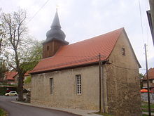
Maina (Magdala)
|
Maina
City of Magdala
Coordinates: 50 ° 54 ′ 20 ″ N , 11 ° 24 ′ 39 ″ E
|
||
|---|---|---|
| Height : | 359 m | |
| Incorporation : | June 30, 1994 | |
| Postal code : | 99441 | |
| Area code : | 036454 | |
|
Location of Maina in Thuringia |
||
Maina is a district of the city of Magdala in the Weimarer Land district in Thuringia .
geography
The village of Maina is located south of the federal motorway 4 between Weimar and Jena . The district of the place lies on the edge of the Magdalaer Graben and goes towards Mechelroda to the barren soil of the Saale-Ilm limestone slab. The traffic connection to the distance is given with the nearby junction of the federal highway 4 near Magdala.
history
The first documentary mention of the village was on October 28, 1285.
church
Web links
Commons : Maina - collection of images, videos and audio files
Individual evidence
- ^ Wolfgang Kahl : First mention of Thuringian towns and villages. A manual. 5th, improved and considerably enlarged edition. Rockstuhl, Bad Langensalza 2010, ISBN 978-3-86777-202-0 , p. 173.

