
Ottstedt (Magdala)
|
Ottstedt
City of Magdala
Coordinates: 50 ° 54 ′ 46 ″ N , 11 ° 25 ′ 18 ″ E
|
|
|---|---|
| Height : | 305 m |
| Area : | 3.21 km² |
| Residents : | 137 (2005) |
| Population density : | 43 inhabitants / km² |
| Incorporation : | June 30, 1994 |
| Postal code : | 99441 |
| Area code : | 036454 |
 |
|
Ottstedt bei Magdala is a district of the city of Magdala in the Weimarer Land district in Thuringia . The place has 137 inhabitants (2005) on an area of 3.21 km².
geography
Ottstedt is a little north of the federal highway 4 between Weimar and Jena . The place is on the southwest edge of the Magdalaer Graben , neighboring communities are Mellingen , Kleinschwabhausen and Lehnstedt .
history
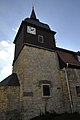
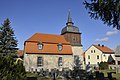
The first written mention as Uthestete is dated October 28, 1285. The place name means "settlement of Ot (i)" (Germanic personal name). The place was in the rulership of the county Weimar-Orlamünde and the Counts of Schwarzburg and came with their property in 1372 to the area of the Wettins . In 1437 the place was mentioned as Otstete in the church book of Magdala. Ottstedt is mentioned as a parish in 1529 and soon afterwards it is parish in Magdala. In 1630 there was a major fire. A teacher is mentioned for the first time in the church book in 1650, and a school for the first time in 1693. Today's church was built in 1783–85. From the Middle Ages until well into the 20th century, most of Ottstedt's citizens worked in agriculture.
A second devastating major fire threw Ottstedt back in its development in 1827. In 1831 the school was rebuilt (today's parish hall). 1916 Connection of Ottstedt to the power grid . In the school year 1947/48 the school was closed and the students were integrated into Magdala. In 1959 the first agricultural production cooperative (type 1) was founded. A consumer outlet was opened in 1974. Between 1970 and 1980 the village stream was piped up to the extinguishing water pond and sidewalks were built.
In the district there were two other villages between the 10th and 14th centuries. The village of Eger , around one kilometer to the northwest, was mentioned in a document in 1194 as Eichorne ("with the people in the oak forest") together with Wellendorf . Wellendorf was 500 meters east of the village.
The old community seal shows a linden tree .
Pictures of the church

View from the southeast
View from the northeast

View from the northeast with the external staircase to the gallery
View from the south


