
Riechheimer Berg
| Riechheimer Berg | ||
|---|---|---|
 The Riechheimer Berg seen from the east |
||
| height | 513 m | |
| location | Thuringia , Germany | |
| Mountains | Ilm-Saale-Platte | |
| Dominance | 12 km → Großer Kalmberg | |
| Notch height | 138 m ↓ saddle between Bösleben and Witzleben | |
| Coordinates | 50 ° 52 '55 " N , 11 ° 7' 45" E | |
|
||
| rock | Shell limestone | |

The Riechheimer Berg is 513.2 m above sea level. NN high mountain about 10 kilometers southeast of Erfurt .
geology
The Riechheimer Berg is located on the limestone hill chain of the northwestern Ilm-Saale-Platte , which extends from the Steigerwald in the northwest to the valley of the Ilm in the southeast and is the highest mountain within a radius of 15 kilometers and the highest elevation in the Weimarer Land district . It lies on the watershed between the Unstrut and the Ilm. On the western side, belonging to the Ilm district and draining over the Gera to Unstrut, is the village of Riechheim and on the eastern side, belonging to the Weimarer Land district and draining the Ilm, is the village of Hohenfelden . The top of the mountain is forested, the western foreland at a height of about 350 meters represents an agriculturally used level, while the red sandstone depression of the Tannroda woodland is immediately to the east . The Krummbach , which feeds the nearby Hohenfelden reservoir, rises on the eastern flank of the mountain .
geography
The mountain is a border mountain: today the border between the Ilm district and the Weimarer Land district runs here. The border between Sachsen-Meiningen in the west and Sachsen-Weimar (-Eisenach) in the east used to run here. This emerges from a boundary stone from 1982 and two other historical boundary stones. Inscriptions on the latter show the inscriptions "SWE" for "Sachsen-Weimar" and "HSM" for "Duchy of Sachsen-Meiningen". The border between Meiningen and Weimar was newly agreed on January 1, 1914 and runs along the summit path. At the same time, the once divided village of Hohenfelden became a united Weimar village. To commemorate the division, a boundary stone was set up on the bridge in the village with the permission of the Weimar Grand Ducal-Saxon State Ministry.
To the north, the border between the former Kingdom of Prussia and the Grand Duchy of Saxony-Weimar runs along a dirt road towards Schellroda and Klettbach , makes a sharp bend to the west at a distance of about 2,380 m as the crow flies at a crossroads in the Weimar Valley at the foot of the Hühnerback , after another 1225 m there is a sharp bend to the north, where after another 645 m at a Dreiherrenstein the border of Erfurt is reached.
- Landmarks on the Riechheimer Berg

Boundary stone from 1982 with height information, district identifications ("Erfurt" and "Arnstadt" (on the back)) and coordinates

Boundary stone with inscription, still recognizable: "SM"

Boundary stone with the inscription "SWE"
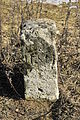
Boundary stone with the inscription "HSM"


history
- Bismarck monument and restaurant

Bismarck monument on the Riechheimer Berg

Middle part of the monument
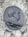
Medallion of the Reich Chancellor

restaurant


In the northern part of the mountain and south of it you can see traces of the ruthless limestone mining during the GDR era. A restaurant of the same name has been located on the mountain since 1895. Its core is a typical Central Thuringian farmhouse implemented from an exhibition in Erfurt, which was built by the innkeeper Hüther from Riechheim and which was built as a Thuringian farmhouse in 1894 by Emil Schönau in Kranichfeld for the trade and industrial exhibition in Erfurt.
South of the restaurant is a Bismarck monument of the "Riechheimer Berggemeinde" from 1907. The medallion of the Chancellor on a limestone wall is a replica of an original made of bronze that the innkeeper family Limprecht / Büchner had secured in the basement from 1945 until the fall of the Wall . In 1995 the completed monument was inaugurated again to mark the 100th anniversary of the restaurant business.
The GDR had planned to set up an anti-aircraft missile system on the Riechheimer Berg, but this was no longer carried out.
In the 1990s, a large one and two-family housing estate was built on the western slope of the mountain above the village of Riechheim, which caused a rapid increase in the number of residents in Riechheim.
Flora and fauna
The spring Adonisröschen can be found on Riechheimer Berg . The mountain is located in the extensive landscape protection area Ilmtal from Oettern to Kranichfeld ( LSG Mittleres Ilmtal ). The eastern slope of the mountain and the Königsstuhl rising south of it belong to the FFH area Riechheimer Berg-Königsstuhl .
tourism
The Riechheimer Berg is a popular destination for hikers; the view is considered excellent ("Thuringian Rigi"). The main Jena – Eisenach hiking trail also leads over the mountain.
Others
The administration community Riechheimer Berg is named after the mountain.
To the north and west of the Riechheimer Berg, a 380 KV high-voltage line with masts up to 100 m high is to be run along for the transport of electricity from wind turbines in the north to Bavaria.
Web links
Individual evidence
- ↑ Map services of the Federal Agency for Nature Conservation ( information )
- ^ Pastor Karl Leib: Heimatbuch des Landkreis Weimar , 1925
- ↑ Flaketenbrigade of the NVA Sprötau