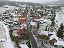
Ohrdrufer plate
| Ohrdrufer plate | ||
|---|---|---|
| Highest peak | Ebanotte ( 517.8 m above sea level ) | |
| location | Central thuringia ( Germany ) | |
| part of | Ilm-Saale- and Ohrdrufer plate | |
| Classification according to | Handbook of the natural spatial structure of Germany | |
|
|
||
| Coordinates | 50 ° 48 ' N , 10 ° 52' E | |
| rock | Shell limestone | |
| particularities | Depending on the demarcation, the White Stone (532.2 m) can also be seen as the highest elevation. | |
The Ohrdrufer plate is part of the southern shell framing of the Thuringian basin , while the western portion of the Ilm-Saale and Ohrdrufer plate in the boundary area of the administrative districts Gotha and Ilm circle in Thuringia .
It lies between the Thuringian Forest in the south and Arnstadt in the north. It divides into the Ohrdrufer plate in the narrower sense west of Gera tales and Ohrdrufer plate in a broader sense , which even the east subsequent Reinsberge to Wipfratal includes.
The article here is limited in the following to the western part, which extends west of the Gera.
Geographical location
The "Ohrdrufer Platte in the narrower sense" is located between the Thuringian Forest in the south, the eponymous city of Ohrdruf in the west, the Drei Gleichengebiet in the north, and the Gera near Plaue in the east. Arnstadt borders the mountain range in the northeast.
Natural allocation
The Ohrdrufer Platte (in the narrower sense) represents the western part of the natural spatial Muschelkalk main unit Ilm-Saale- and Ohrdrufer Platte (474) within the main unit group Thuringian Basin (with edge slabs) (47/48). The Reinsberge are connected to the east and further to the northeast the Ilm-Saale-Platte .
The structure that only exists within Thuringia The natural spaces of Thuringia of the Thuringian State Institute for Environment and Geology (TLUG) counts them to the shell limestone plates and mountainous countries .
Adjacent landscapes and natural spaces are clockwise:
- the Thuringian Forest in the south and south-west
- the Ohrdrufer Bay within the West Thuringian mountain and hill country in the west
- the Drei Gleichen area along the Eichenberg – Gotha – Saalfelder fault zone with the Thuringian Basin behind it in the north
- the Reinsberge in the east
landscape
The limestone plateau, which slopes gently to the north, is poor in water and is strongly structured by individual valleys, especially in the eastern part. The plateau is determined by limestone flora, the steeper sections in the east and south are more heavily forested. The Ohrdrufer plate can be divided into the following landscape parts:
- the flatter and mostly unwooded western Ohrdrufer Platte with the Ohrdruf military training area
- the Jonastal
- the Gossel plateau
- the southeastern part between the Wilden Gera and the Reichenbach south of Plaue
Surveys
The following surveys of the individual parts of the landscape are worth mentioning:
-
Western part
- Baumgarten (505.6 m), northeast of Wölfis
- Musketierberg (460.6 m), northeast of Ohrdruf with the northern foothills Hainberg (460.0 m) south of Wechmar
- Goldberg (453.8 m), southeast of Ohrdruf
- Hardt (452.2 m), north of Wölfis
- nameless mountain (446 m), south of Mühlberg
- Gossel plateau
-
Southeast part
- White stone (532.2 m), south of Angelroda
- Kammberg (525.8 m), east of Graefenroda
- Bringeberg (483.9 m), north of Geraberg
Individual evidence
- ^ E. Meynen and J. Schmithüsen : Handbook of the natural spatial structure of Germany - Federal Institute for Regional Studies, Remagen / Bad Godesberg 1953-1962 (9 deliveries in 8 books, updated map 1: 1,000,000 with main units 1960)
-
^ Walter Hiekel, Frank Fritzlar, Andreas Nöllert and Werner Westhus: The natural spaces of Thuringia . Ed .: Thuringian State Institute for Environment and Geology (TLUG), Thuringian Ministry for Agriculture, Nature Conservation and Environment . 2004, ISSN 0863-2448 . → Natural area map of Thuringia (TLUG) - PDF; 260 kB → Maps by district (TLUG)
- ↑ Map services of the Federal Agency for Nature Conservation ( information )


