Ohrdruf military training area
|
Ohrdruf military training area |
|
|---|---|
 internal association badge |
|
| active | from 1871 to December 31, 2013 |
| Country |
|
| Armed forces | armed forces |
| Organizational area |
|
| Insinuation | Territorial Tasks Command of the Bundeswehr |
| Location | Ohrdruf Thuringia |
The military training area Ohrdruf (military short form TrÜbPl Ohrdruf , civil also TÜP Ohrdruf ) is a military training area in Thuringia that was laid out in 1906 and has been used almost continuously since then . On October 26, 2011, as a result of the 2011 stationing concept, it was decided to close the TrÜbPl Ohrdruf.
geography
The military training area is located in Central Thuringia in the city triangle Gotha - Arnstadt - Ohrdruf , just south of the federal highway 4 in the district of Gotha and to a lesser extent in the Ilm district . Adjacent places are (clockwise): Schwabhausen , Drei Gleichen with the districts Günthersleben , Mühlberg and Wechmar , the municipality Amt Wachsenburg with the districts Holzhausen , Bittstädt and Röhrensee , the rural community Geratal with the districts Gossel , Liebenstein and Frankenhain , the Arnstadt district Espenfeld , the town of Ohrdruf , the Georgenthal districts of Hohenkirchen and Petriroda and the municipality of Emleben .
The north-south extension of the Ohrdruf military training area is around 8.5 kilometers, its east-west extension around 11.5 kilometers. The highest peaks are the mountain called Kalahari ( 500.2 m above sea level ) in the southeast and the Musketeer Mountain ( 460.3 m above sea level ) in the north.
history
The beginning until 1918
The area around the Ohrdrufer Platte , which is unfavorable for agricultural cultivation , has also been used as a maneuvering area by the Thuringian states since the 19th century . After the founding of the German Empire , the Duchy of Saxe-Coburg and Gotha also tried to gain importance in the military field. In the south of the city of Gotha an extensive racetrack was laid out on the Boxberg (also for cavalry training ). In the east of Gotha, an airship port was built later, which was inaugurated on July 9, 1910 with the opening of the Carl Eduard airship hall and which was also allowed to be used by military airships. In the following years, numerous airships "in transit" arrived in Gotha. In March 1914, the military authorities ordered on a plot next to the Gothaer waggon the military aviator barracks Gotha to build with private airfield, it was put into service on February 18 1915th
Smaller shooting ranges for the infantry were on Krahnberg and Seeberg . Thuringia was the XI. Assigned to Army Corps . The establishment of maneuvering areas decided by the Reich government was discussed controversially in Central Thuringia. The town of Langensalza , which belongs to Prussia , also tried to get the garrison town , large landowners in the Arnstadt area feared for their existence and rejected the plans of the Gotha State Ministry, so the maneuvering area was mainly laid out on Gotha territory around the town of Ohrdruf. The examples given show that the Ohrdruf military training area became increasingly important as a maneuvering area until the First World War.
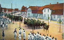
On May 21, 1908, the 1st Battalion of Infantry Regiment No. 95, the first military unit arrived in the area. The commanding general von Scheffer-Boyadel ordered the construction of a camp town as permanent quarters, and permanent accommodation for an infantry regiment and a cavalry regiment were built by 1912. At the same time it became necessary to clear the Heerda and Hundsbrunn estates, which were threatened by target practice in the extensive area. The boundary of the military area was marked by warning signs, and additional barriers and signal masts were set up during target practice to increase the safety of civilians.
During the First World War , the front training of the Thuringian recruits took place on the Ohrdrufer training ground. On January 29, 1915, Kaiser Wilhelm II visited the camp personally to find out about the training of reservists.
A prisoner of war camp for 10,000 inmates had already existed in a separate part of the military training area since 1914 . Contemporaries described the conditions of the place known as the north camp as "humane". The majority of the prisoners were French military personnel, they were requested from the neighboring towns to work in the fields or to build roads. A field hospital was built to take care of the wounded, as well as a cemetery for the deceased; a specially erected memorial stone is still in place. The prisoner-of-war camp was dissolved in April 1916, as most of the prisoners were already permanently housed on work detachments outside the camp. The prisoners still in the camp were transferred to the Langensalza prisoner of war camp. The camp was then used to accommodate wounded German soldiers. After the armistice in 1918, the political situation in Thuringia also came to a head. Workers 'and soldiers' councils were formed, and the previous military camp leadership was disempowered. The units stationed in Ohrdruf disbanded, resulting in looting and vandalism.
1933 to 1945
After the seizure of power in January 1933, the construction of barracks began in May 1934 to provide accommodation for the I Department of Motor Vehicle Training Command II - Ohrdruf and staff, which was set up at the same time ; on July 1, 1934, the Kraftfahr-Lehrkommando II was added with two departments. Due to the conditions in the Peace Treaty of Versailles , which u. a. a ban on heavy weapons such as tanks , mobilization measures and a restriction of the Reichswehr to a maximum of 100,000 men were initially trained undercover.
On October 15, 1935, larger motorized units were set up, namely the Panzer Regiments 1 Erfurt and 2 Eisenach (most of which were recruited from the two motor vehicle training commandos), as well as the artillery regiments 73, 74 and 75 . Furthermore, the PzReg 7 was set up, which was then relocated to the Bavarian region.
On August 1, 1936, Günther von Goeckel became the commandant of the Ohrdruf military training area (until November 30, 1943). Under his command, a secret telecommunications system of the Reichspost ( camouflage designation Amt 10 or Olga ) was set up in the same year and the 7th Panzer Regiment was set up. In 1937 the construction of the barracks building in the north-western area of the area began, and air raid systems were added from spring 1939 .
Due to the tactical needs of the Wehrmacht in World War II , the 16th Infantry Division in Ohrdruf was transformed into the 16th Panzer Division from August to November 1940 .
In 1941/42, a small camp for Russian prisoners of war was initially set up at the Ohrdruf military training area; this was taken over by the SS in autumn 1944 and run as a satellite camp of the Buchenwald concentration camp .
On the Jonastal , which is now part of the military training area, the construction of underground tunnels began in November 1944 as part of the special construction project S III , but it was no longer completed.
1945 to 1947
On April 5, 1945, Ohrdruf was captured by the 4th US Armored Division . Initially, a transit camp for released Russian prisoners of war was set up at the military training area.
1947 to 1991
Starting from 1947, first used the Soviet forces which later NVA the GDR the area as a military training area. As a result of German reunification , the Ohrdruf training area became the property of the Federal Ministry of Defense in 1991 .
Since 1991
After the Warsaw Pact troops had finally withdrawn , the site was taken over by the Bundeswehr on December 22, 1993 . In autumn 2011 it became known that the Ohrdruf military training area was to be abandoned. Since the beginning of December 2013, the place is no longer a military training area, but a site training area for the Friedenstein barracks in Gotha .
See also
literature
- Adrian Ermel: Neighborhood between practice and emergency. The economic and social effects of a military presence using the example of the military site in Ohrdruf in Thuringia between 1906 and 2009 . Rockstuhl Publishing House , Bad Langensalza 2010.
- Peter Schmidt; Manfred Ständer: 100 years of the Ohrdruf military training area 1906–2006 . Horb am Neckar 2006.
- Peter Cramer and Dieter Zeigert u. a .: Ohrdruf military training area . 2nd revised edition, ed. from the community of interests Schloß Ehrenstein eV, Heinrich Jung Verlagsgesellschaft, Zella-Mehlis u. a. 1997, ISBN 3-930588-23-4 .
Web links
- Jonastal
- Jonastalverein eV ( Memento from February 6, 2013 in the web archive archive.today )
Individual evidence
- ↑ Stationing concept 2011 ( Memento of October 30, 2011 in the Internet Archive ) (PDF; 146 kB), 4.3.16 Thuringia.
- ↑ a b Official topographic maps of Thuringia 1: 10,000. Wartburgkreis, district of Gotha, city of Eisenach . In: Thuringian Land Survey Office (Hrsg.): CD-ROM series Top10 . CD 2. Erfurt 1999.
- ↑ The first visit by an airship, it was the Parsival , took place on the evening of November 14th, 1909. The approach in an approaching snowstorm forced the crew to make an emergency landing and subsequent dismantling of the aircraft.
- ↑ Heiko Stasjulevics: Gotha - the aviation city . In: Gothaer culture and tourism company (ed.): The Gothaer museum booklet on regional history . 1992, ISSN 0863-2421 , p. 64-78 .
- ↑ a b c Peter Cramer, Thomas Franke et al: military training area Ohrdruf . Heinrich-Jung Verlagsgesellschaft, Zella-Mehlis / Meiningen 1995, ISBN 3-930588-23-4 , p. 28-54 .
- ↑ Bundeswehr wants to give up training area in Ohrdruf. In: TA. October 28, 2011
- ↑ thueringer-allgemeine.de
Coordinates: 50 ° 51 ′ 31 ″ N , 10 ° 46 ′ 10.2 ″ E
