Gossel
|
Gossel
Rural community of Geratal
|
|
|---|---|
| Coordinates: 50 ° 47 ′ 54 ″ N , 10 ° 51 ′ 0 ″ E | |
| Height : | 490 m |
| Area : | 13.61 km² |
| Residents : | 460 (December 31, 2017) |
| Population density : | 34 inhabitants / km² |
| Incorporation : | 1st January 2019 |
| Postal code : | 99330 |
| Area code : | 036207 |
Gossel is a district of the rural community Geratal in the Ilm district in Thuringia in Germany .
geography
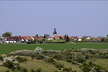
Gossel lies on the "Gosseler Plateau", which is part of the Ohrdrufer Platte and consists of a shell limestone formation about 500 meters high . The Gosseler Plateau occupies the southwestern part of the district, where the town of Gossel is also located. In the north the Jonastal runs through the local area. It forms an attractive, almost 100 meter deep incision in the Ohrdrufer plate. The areas north of the Jonastal are forested and belong to the Ohrdruf military training area . In the east of the town between Gossel and the neighboring town of Espenfeld there are also some forest areas. The neighboring towns to the west are Crawinkel and Wölfis , while Liebenstein is to the south . The Thuringian Forest begins about five kilometers southwest of the village.
Neighboring places
Clockwise, starting in the north: Wachsenburg Office , Arnstadt , Plaue , Liebenstein, Crawinkel, Wölfis
history
Gossel was first mentioned in a document in 1143. On July 10, 1671, four lightning bolts struck from a thunderstorm and sparked a conflagration, as a result of which the church, its tower and the four bells, as well as all "spiritual and common" buildings and 34 houses (not counting stables and barns) were burnt in ashes . There was also a shower of hail that ruined the harvest. That happened only a few decades after the Thirty Years' War , in which the Swedish troops passing through had burned the place almost completely down. Until the end of the 18th century, trade was an important source of income: the place had - similar to its neighboring town Crawinkel - several truckers who exported the local goods to northern Germany and via the Thuringian Forest to Nuremberg and Frankfurt and coffee on the way back , Tea, sugar, spices and other goods for Gossel and the neighboring towns.
A major fire destroyed 19 residential buildings and the rectory in 1849, but the church was spared. She was also spared in 1945 when a unit of the Waffen SS holed up in the village as the Americans approached. However, there is the following report from the fire brigade in the neighboring village of Liebenstein : "In January 1944, the neighboring community of Gossel was hit by fire bombs in the center (around the church) . The church and neighboring farms were on fire . The Liebensteiner Wehr hurried with its engine-powered engine on Otto's tractor Ehrhardt (landowner) to help ".
The place belonged to the Amt Wachsenburg , which in 1640 became part of the Duchy of Saxony-Gotha , from 1672 to the Duchy of Saxony-Gotha-Altenburg and in 1826 to the Duchy of Saxony-Coburg and Gotha .
In 1994 Gossel came to the Ilm district. From 1996 it belonged to the administrative community of Upper Geratal . The administrative seat was in the municipality of Graefenroda . With the dissolution of the administrative community on January 1, 2019, Gossel came to the rural community of Geratal.
Population development
Development of the population:
|
Data source: from 1994 Thuringian State Office for Statistics - values from December 31st
politics
(District) mayor and district council
The district mayor of Gossel is Andreas Gundermann (CDU). Together with four other members, it forms the local council. Gundermann has been the honorary mayor since 1999 and was last re-elected on June 5, 2016 in the then still independent municipality.After the incorporation in Geratal, he will hold the office of the district mayor for the rest of his term of office. Before that, Hartmut Unger (CDU) was the honorary mayor of Gossel from 1994 to 1999.
coat of arms
The coat of arms was designed by the heraldist Frank Diemar and approved on March 1, 1995 by the Thuringian State Administration Office.
Blazon : “In black, the bust of a man with a golden beard and hair in a golden robe and a golden hat decorated with a shell, holding a golden curved rod in both hands, accompanied by three (2: 1) golden balls at the top right; In the golden base of the shield three black common crosses arranged in bars. "
The main motif of the coat of arms goes back to a seal motif used since the 17th century; St. James with a pilgrim's staff could possibly be associated with the former Cistercian nunnery that was used as a place of pilgrimage. A St. Jakobs sculpture created in 1909 has been preserved in the townscape to this day. The three spheres attached to the symbol stand as attributes of St. Nicholas for a church in Gossel that no longer exists and was dedicated to this saint. The three crosses in the base of the shield symbolize three atonement crosses present in the locality.
Culture and sights
Village church

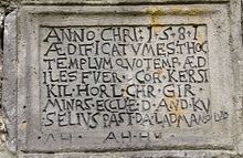
The Marien-Kirche was built as a monastery church in the middle of the 13th century, its current shape is from 1581. This is also evident from an inscription that is embedded as a stone tablet in the church wall. In 1675, after the fire described under "History", a renovation took place, with financial support from Duke Ernst I. The church survived unscathed a major fire in 1849 and the invasion of the Americans in 1945. However, a lightning strike on Whit Saturday 1992 caused considerable damage to the tower , Roof and electrical system, but spared the nave.
The early baroque interior was created by 1680. The gallery fields are decorated with scenes from the biblical story (1703). Around 1860 the church got a Knauf organ with a prospectus from the first half of the 19th century from the Ratzmann workshop. On the occasion of a redesign in 1979, the altar was moved from a niche in the choir to its current location and a baptistery was set up at its old location.
The parish belongs to the Wölfis parish .
Memorials
In the local cemetery , graves and a memorial stone commemorate seven people who were deported to Germany during the Second World War and were victims of forced labor .
Stone crosses
Of the former seven crosses near Gossel, only three stone crosses are left north of the village . The locations of the four missing crosses were still detectable in 1993. The stone cross nest is located on the mountain Ebanotte (517.8 m above sea level), which can be seen from afar , on which an old high path led from the Thuringian Forest over the Gosseler Plateau and the Alteburg to Arnstadt. Stone walls on the Ebanotte suggest a prehistoric castle site. The old trade route is still preserved today as part of the connection from Gossel to Espenfeld : From Arnstädter Straße , about 200 m after the end of the village, the path branches off to the right and leads over the northwest slope of the Ebanotte back to the road to Espenfeld. It is said that the stone crosses are reminiscent of pilgrims who got into an argument after a carousing party in the inn and of whom seven were killed in the end. ( Location → )
Carpenter's cross
In the district of Gossel, off the road in the direction of Espenfeld on Mount Ebanotte, there is still the carpenter's cross, also called the individual cross. It should either mark a cemetery, someone should have frozen to death here, or the last catfish was killed here. However, details of the cross are still known.
Osterpfitzen
A long-standing tradition is the Osterpfitzen the lads guild since 1912th
Personalities
- Johann Nicolaus Hanff (born September 25, 1663 in Gossel, † Christmas 1711 in Schleswig), German organist
- Johann Valentin Scherlitz (* in Gossel; † 1793 Gotha), chamber musician and court organist of Duke Ernst Friedrich
- Jens Filbrich (born March 13, 1979 in Suhl), German cross-country skier, has lived in Gossel since 1997
- Konrad Bach (born October 6, 1940; † March 28, 2019 in Gossel), composer and conductor with the Thuringian Symphony Orchestra Saalfeld-Rudolstadt and at the State Theater Eisenach
Web links
Individual evidence
- ^ Galletti : History and description of the Duchy of Gotha , Gotha 1780, p. 319
- ↑ 700 years of Liebenstein . Festschrift. Edited by the community of Liebenstein. 2003, p. 86
- ↑ Thuringian Law and Ordinance Gazette No. 14/2018 p. 795 ff. , Accessed on January 1, 2019
- ^ Source for Schwarzburgische and Saxon places: Johann Friedrich Kratzsch : Lexicon of all localities of the German federal states . Naumburg, 1843. Available online from Google Books . Source for Prussian places: Handbook of the Province of Saxony. Magdeburg, 1843. Available online at Google Books
- ^ Michael Rademacher: German administrative history from the unification of the empire in 1871 to the reunification in 1990. Population figures. (Online material for the dissertation, Osnabrück 2006).
- ↑ Population development since 1989 (TLUG) ( Memento of the original from October 29, 2012 in the Internet Archive ) Info: The archive link has been inserted automatically and has not yet been checked. Please check the original and archive link according to the instructions and then remove this notice. (PDF; 18 kB)
- ↑ Municipality of Geratal: Official Journal, Volume 1, No. 12-14 June 2019, accessed on August 31, 2019 .
- ^ Thuringian State Office for Statistics: Elections in Thuringia, mayoral elections in Gossel. Accessed August 31, 2019 .
- ^ New Thuringian Wappenbuch Volume 2, page 12; Publisher: Arbeitsgemeinschaft Thüringen eV 1998 ISBN 3-9804487-2-X
- ↑ HE Müllerott: Legends, fables and romantic stories from the central Thuringian Forest and its foreland. Arnstadt 1995/1996, ISBN 3-910132-54-5 , pp. 66-68.
- ↑ Stone Cross Gossel
- ↑ Hans Michael Schletterer: Scherlitz, Johann Valentin . In: Allgemeine Deutsche Biographie (ADB). Volume 31, Duncker & Humblot, Leipzig 1890, p. 119 f.
- ^ " Brother -in-law Chronos" - Obituary for Konrad Bach. Retrieved December 18, 2019 .


