
Crawinkel
|
Crawinkel
City of Ohrdruf
|
|
|---|---|
 |
|
| Height : | 469 m |
| Area : | 25.23 km² |
| Residents : | 1446 (December 31, 2017) |
| Population density : | 57 inhabitants / km² |
| Incorporation : | 1st January 2019 |
| Postal code : | 99885 |
| Area code : | 03624 |
Crawinkel is a district of Ohrdruf in the Thuringian district of Gotha .
geography
Crawinkel is located on the northern edge of the Thuringian Forest . The district town of Gotha is about 20 kilometers, the state capital Erfurt about 30 kilometers north. The Oberhof winter sports center is approx. 10 km away.
history
The first written mention of Crawinkel was in 1088 in the annals of the monastery of Goseck as Cravunkele . Previously, the Counts of Kevernburg are said to have founded a Marienkapelle at this point around 1065 as a prayer for the blessed passage over the Rennsteig - the Gravincella .
The place belonged to the Amt Wachsenburg , which in 1640 came to the Duchy of Saxe-Gotha , from 1672 to the Duchy of Saxe-Gotha-Altenburg and in 1826 to the Duchy of Saxe-Coburg and Gotha .
Galletti comments on Crawinkel in his topographical-historical description of the Gotha Duchy from 1780:
- Because of its high altitude, the place has healthy air. There are plenty of paving stones and limestone, and good millstones are also broken. There is also no lack of healthy water and there are many fountains in the village. A small brook, which flows through the place, drives a mill. There are also different ponds. Agriculture is, as usual in forest areas, mediocre and arduous. The better is the Trift (cattle farming).
- The place is called Gravincella (Grafenzella) in documents and, like Graefenhain and Graefenroda , it probably owes its origin to the Counts of Kevernburg or von Gleichen . There were also Lords of Crawinkel in the Middle Ages. The village was ravaged by a fire in 1624 (incorrectly 1664), which consumed the church, the parish and school house, the gift and painting house, 113 houses and 116 barns. It's pretty big because it has 209 houses and 934 residents. From 1773 to 1779 there were 40 marriages, 142 born and 110 deceased ...
- There are many carpenters, charcoal burners, carbon black burners and wood cutters among the inhabitants. The soot is driven far away and the carters bring other goods back with them. In the summer the many kinds of berries that grow in the forest contribute to the nourishment of the inhabitants. They are also allowed to read wood three times a week in the stately forest. The community owns a piece of wood.
- She also has the brewing and gift-giving justice, at the same time the right to hold a Weissbecker. At Ohrdruf, the crawinklers have the same market rights with the citizens. Because of the country road that leads through the forest, there are three inns here. The old Marienkapelle was converted into a church in 1613, but it burned down in 1624. So it had to be performed again. Before the Reformation, the monastery at Breitenbach is said to have been the feudal lord of this church.


The life of the village was based on various branches of business. The mill quarry near the Lütsche village was important . On the other hand, it was the carter system that created good conditions due to the location of the place on the important trade route between the episcopal city of Erfurt and the trading metropolis of Nuremberg . Due to the extent of the Thuringian Forest, the sometimes narrow and steeply rising trade routes could not be bypassed. One of these roads led from Arnstadt to Crawinkel and through the Steiger Hohle (valley cut on the Steigerberg near Frankenhain ) to Oberhof and over the Rennsteig to Zella St. Blasii . The Steiger Cave was very narrow, so an agreement was reached that carts were only allowed to drive uphill in the morning and downhill in the afternoon. So if you arrived in Crawinkel too late to continue uphill, you had to wait the next day and spend the night in town. Since the constantly changing one-way street was not safe from robberies at that time, additional armed escorts were required for the carts. Further handicrafts and especially restaurants and rest houses developed around the trade route.
Crawinkel was once a historically significant center of Thuringian musical instrument making, where excellent violins and cisterns were built. Numerous preserved instruments from the 18th and 19th centuries in various museums in Europe, such as the Bachhaus Eisenach , the Musikinstrumentenmuseum Leipzig, the Hessisches Landesmuseum Darmstadt , the Gemeentemuseum Den Haag and the local museum "Alte Mühle" Crawinkel testify to the former skills of the instrument makers from Crawinkel .
On December 1, 1910, 1740 inhabitants lived in Crawinkel.
Due to its proximity to the Jonastal, the village of Crawinkel became the most important material handling point for one of the most secret building projects in the Third Reich under the name S III during the final phase of the Second World War . In the Jonastal and under the Ohrdruf military training area , one of the alternative Führer headquarters was presumably built. A light rail link ran from Crawinkel to directly in front of the tunnel system. The village was two-thirds destroyed in April by air raids and artillery fire. Shortly beforehand, the historic Compiègne armistice wagon was parked in the immediate vicinity of the Crawinkler train station. A little further away, he fell victim to a fire on April 12, 1945, the cause of which is not certain. As a sign of Franco-German reconciliation, an oak from Crawinkel was planted in the Compiègne forest in 1994 .
More than a hundred forced laborers from various countries worked in the nearby air munitions facility 1 / IV , which had been built since 1934 and inaugurated on May 10, 1935. From January 1945, the underground ammunition bunkers were increasingly converted to accommodate up to 3000 concentration camp prisoners from Buchenwald . The so-called Camp C was a satellite camp of the S III subcamp from Buchenwald to the Ohrdruf forced labor camp . Many of the prisoners were killed on a death march in April 1945.
From July 1, 1945, the village became part of the Soviet occupation zone , and from October 7, 1949, the GDR . With the territorial reform in 1952, the Arnstadt district came into being , and since 1994 it has been part of the Gotha district again. This incorporation into the Gotha district, wanted by the Crawinkler citizens, led shortly thereafter to massive protests by the citizens, up to and including the blockage of the federal highway 88 that ran through the town.The reason for the ultimately unsuccessful protests was the significantly higher municipal taxes of the Gotha district.
On January 1, 2019, the independent municipality of Crawinkel was incorporated into the city of Ohrdruf. Earlier, Ohrdruf was already a fulfilling church for Crawinkel.
traffic
.jpg)
The place is on the B88 . During the GDR era there was a lot of traffic on it, and the important pass road to Oberhof branched off from it in Crawinkel. However, with the opening of the Thuringian Forest A71 , traffic on the B88 fell sharply. Long-distance transport there is only very little.
Crawinkel is on the Gotha – Graefenroda railway line , which reached the place in 1892. The original plan of the Gotha dukes to expand this line into the main line to the ducal resort of Elgersburg and to cross the Thuringian Forest via Ilmenau, however, turned out to be far too expensive, so that the line was built as a branch line with narrow radii. Since 2011, there has been no scheduled traffic on this route, which was completely renovated until 2005. The route from Gotha via Ohrdruf, Crawinkel and Frankenhain to the main line Erfurt – Würzburg in Gräfenroda is still available, but is no longer used as planned.
Friedrich start
The place Friedrichsanfang was incorporated into Crawinkel in 1859. Friedrichsanfang originated as a colonist settlement and was laid out at the instigation of the ducal forest administration in the 17th century. In 1780 it consisted of an inn and three forest farmers' houses. The living conditions were much tougher than in the Crawinkler community. The colonists lacked the money and job opportunities to make a living. In 1858 the responsible district administrator in Ohrdruf was commissioned by the ducal administration to incorporate the small settlement Friedrichsanfang, now consisting of 10 houses and about 50 inhabitants, into Crawinkel. The plan immediately met with fierce resistance from the crawinkler population. You saw yourself as a victim of an arbitrary state measure and protested at the ducal state ministry. The reason for the quarrels was the fact that some families living in Friedrichsanfang had been dependent on material support for a long time due to the adverse living conditions. The crawinklers demanded a state contribution of 1,000 thalers to help these families, but at that time there was no social security and the district administrator refused this large sum on behalf of the government. After an emergency meeting, the community leader received a permit for a maximum of 200 Reichstaler and gave in to pressure from the authorities. On January 30, 1859, Friedrichsanfang was incorporated into Crawinkel.
Crawinkel - a city?
In fact, Crawinkel seems to have received town charter in the Middle Ages. There is no document for this, but Crawinkel is referred to as a city in a document from 1340. Crawinkel is also referred to as a city in a diploma from Landgrave Friedrich von Thuringia in 1360. That would not be illogical, because in the Middle Ages Crawinkel was a relatively large place at the beginning of the important pass road over the Thuringian Forest near Oberhof on the Erfurt – Nuremberg / Würzburg trade route. In addition to the hostel system, which was important on the route at that time, and the opening credits from Crawinkel on the pass road, Crawinkel also had an important trade with the quarries and raftsmen on the Leinakanal . The triangular square in front of the community tavern, which is still called the “market” today, also speaks for the city charter. In the Middle Ages, market law and town law were usually related. Another indication of city law is that the community tavern was called "The old Ratskeller" for a long time. From the middle of the 20th century, there is still information from residents according to which the councilors held their meetings in the same Ratskeller, whose building was probably the town hall. They sat raised on a pedestal at their "gentlemen's table". This table stood for a long time in the hall that was added later. The current files of the councilors had their place in a lockable wall cupboard in the dining room. Older documents and certificates lay in a large wooden chest in the attic of the house. The chest can still be found in the attic until the 1950s.
According to old traditions, Crawinkel sold or lost his town charter to Ohrdruf. One version of the story says that Crawinkel became very impoverished after the great fire of 1624 and sold the town charter to Ohrdruf for 100 thalers in order to rebuild the church with the money.
politics
Municipal council
The municipal council consisted of 12 councilors until it was incorporated into Ohrdruf.
| Parties and constituencies | 2014 | 2009 | 2004 | 1999 | 1994 | ||||||||||
|---|---|---|---|---|---|---|---|---|---|---|---|---|---|---|---|
| Share a | Seats | Share a | Seats | Share a | Seats | Share a | Seats | Share a | Seats | ||||||
| Christian Democratic Union of Germany | CDU | 46.8 | 6th | 22.8 | 3 | 36.3 | 4th | 37.0 | 5 | 15.3 | 2 | ||||
| Social Democratic Party of Germany | SPD | 40.7 | 5 | 65.1 | 8th | 55.2 | 7th | 36.7 | 4th | 29.7 | 4th | ||||
| Alternatives for Crawinkel | AfC | 12.5 | 1 | 12.1 | 1 | - | - | - | - | - | - | ||||
| Crawinkel independent voter community | UWG C | - | - | - | - | 8.5 | 1 | 26.3 | 3 | - | - | ||||
| German Social Union | DSU | - | - | - | - | - | - | - | - | 46.4 | 6th | ||||
| Free Democratic Party | FDP | - | - | - | - | - | - | - | - | 5.0 | - | ||||
| Independent voter community | UW | - | - | - | - | - | - | - | - | 3.6 | - | ||||
| percentage of invalid votes | 5.6 | 4.5 | 5.9 | 4.0 | 3.8 | ||||||||||
| Total seats | 12 | 12 | 12 | 12 | 12 | ||||||||||
| voter turnout | 66.7% | 59.4% | 63.5% | 72.4% | 83.3% | ||||||||||
mayor
Onno Eckert (SPD) was elected mayor on June 6, 2010. With a turnout of 73.4%, he received 81.1% of the vote. He was in office until the church was dissolved.
coat of arms
Blazon : "In red, a golden horse with an upright black steed turned to the right, top that rises to the head of the shield, a silver six-spoke wheel in front and a silver millstone behind."
Community partnerships
Since July 1992 there has been a partnership with the municipality of Juniville in France . There is also a partnership with the Baden-Württemberg community of Kusterdingen .
Culture and sights

Buildings

- One of the sights of the community is St. Mary's Church from 1758. The tower with its Gothic vault and the inscription in the sacristy from 1421 are the oldest parts of the building that have survived. In 1613/14 a church was built from this chapel. On May 4, 1624, in a devastating conflagration in the Thirty Years' War, 113 residential buildings and 116 barns fell victim to the flames. The successor building was changed from 1754 to include the still existing masonry and tower, the baroque interior with the three-storey galleries dates from 1758, the baptismal font from 1781. From April 7th to 11th, 1945 Crawinkel experienced fierce battles in which the church was also difficult Sustained damage. The SS had successfully prevented the white flag from being hoisted at the top of the church tower. About 75% of the local building stock was affected, 67 houses were totally destroyed and 12 citizens lost their lives.
- Around 1980 the church was in danger of collapsing, and strong dry rot infestation was found in the masonry , whereupon the church was renovated from 1988 to 1991. In 1999–2002 the Poppe organ from 1866 from the monastery church in Bad Klosterlausnitz was put into service. The installation was carried out by the Rösel & Hercher Orgelbau workshop from Saalfeld. The church is spaciously surrounded by an old defensive wall.

- The historical community tavern on the market square was established in 1564, the fate of the village was negotiated in the old Ratskeller. A relief stone slab next to the entrance door reminds of the laying of the foundation stone. The building has a cross-vaulted cellar with cellar walls up to 1.85 m thick. The thickness of the walls is “an unsolved mystery”, as it says on an information board. In the basement wall towards the church there seems to have been a larger passage. Perhaps the building is the remains of an earlier monastery or a mint.
- Not far from Crawinkel are tunnels in the Jonastal .
Memorials
- A memorial in the local cemetery commemorates 13 concentration camp prisoners and forced laborers who died during their forced labor or were murdered by SS men on a death march in April 1945 . A common grave with a tombstone honors three named Poles who were victims of forced labor. Another grave with a gravestone commemorates a named Yugoslav victim.
- A stele from 1984 on Erfurter Straße commemorates the victims of the death march of April 1945
- A memorial stone and a buffer stop on Juniville Square commemorate the destruction of the Compiègne armistice car at the end of the Second World War near the Crawinkler train station . The Alte Mühle community center provides further information .
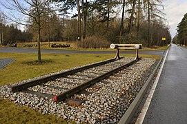
Buffer stop as a reminder of the last location of the wagon in Crawinkel
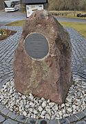
Memorial stone

Plaque on the memorial stone


Sports
The Crawinkel airfield with the Crawinkel air sports center and the Crawinkel glider club is located near the municipality. Due to the special thermal conditions, the area of the municipality is considered to be favorable for hang-gliding , paragliding and gliding . The course offers direct thermal and leeward entry to the mountains thanks to its optimal location on the Rennsteig of the Thuringian Forest. In wave flight conditions (wind from SW), the main wave of the Thuringian low mountain range is in the immediate vicinity of the Crawinkel airfield.
One of the many clubs in Crawinkel is the sports club SG Jugendkraft Crawinkel eV It consists of seven departments (football, weightlifting, gymnastics, bowling, skiing, table tennis and volleyball).

To the north of Crawinkel is the model airfield of the MFC Crawinkel motor flying club . The model airfield is approved by the Federal Aviation Office. The ModellFliegerClub Crawinkel has existed since 1962.
Personalities
Sons and daughters of the place
- Peter Kraußer (* 1941), former SED functionary in the GDR
- Karl Friedrich Andreas Jacobi (1795–1855), mathematician and teacher
- Fritz Mey (1904–1993), circus director, holder of the Federal Cross of Merit
- Friedrich Triebel (1888–1960), NSDAP politician
People connected to the place
- Petra Heß (* 1959), SPD politician, lives here
- Katrin Weißensee (* 1976), sand painter, grew up here
literature
- Joh. Georg August Galletti: " History and Description of the Duchy of Gotha " . 3rd part. Gotha 1780, p. 316-318 .
Web links
Individual evidence
- ↑ Otto Dobencker (arr. And ed.): Regesta diplomatica necnon epistolaria historiae Thuringiae (approx. 500 - 1152) . tape 1 . Fischer, Jena 1896. No. 950.
- ^ History and description of the Duchy of Gotha, 1780, by Johann Georg August Galletti
- ↑ http://www.gemeindeververzeichnis.de/gem1900/gem1900.htm?coburg/ohrdruf.htm
- ↑ Dankmar Leffler: 70 years of the powder keg in Thuringia - The Muna between Crawinkel - Wölfis - Luisenthal and Ohrdruf ; 2004
- ↑ Thuringian Association of the Persecuted of the Nazi Regime - Association of Antifascists and Study Group of German Resistance 1933–1945 (Ed.): Heimatgeschichtlicher Wegweiser to places of resistance and persecution 1933–1945 , Volume 8: Thuringia; Frankfurt / Main: VAS, 2003; ISBN 3-88864-343-0 ; P. 83.
- ^ N. N .: Poor families as a sticking point. Territorial reform 150 years ago: Friedrichsanfang came to Crawinkel . In: Heimatkreis Gotha city and country (ed.): Gothaer Heimatbrief . Issue 54. Gotha 2009, p. 56-57 .
- ^ Käthe Bohnhardt: Heimatliches von Crawinkel in the Thuringian Forest ; Hans-Peter Ewald printing house in Plaue, 1994
- ↑ 2014 municipal council elections in Thuringia - final result. In: wahlen.thüringen.de. Retrieved March 4, 2018 .
- ↑ 2009 municipal council elections in Thuringia - final result. In: wahlen.thüringen.de. Retrieved March 4, 2018 .
- ^ 2004 municipal council elections in Thuringia - final result. In: wahlen.thüringen.de. Retrieved March 4, 2018 .
- ^ 1999 municipal council elections in Thuringia - final result. In: wahlen.thüringen.de. Retrieved March 4, 2018 .
- ^ 1994 municipal council elections in Thuringia - final result. In: wahlen.thüringen.de. Retrieved March 4, 2018 .
- ↑ Mayoral election on June 6, 2010 in Thuringia - final result. In: wahlen.thüringen.de. Retrieved March 4, 2018 .
- ^ Ulrich Völkel: Hospitable Thuringia. 1993, ISBN 3-929662-00-0 .

Crawinkel with the beginning of Friedrich | Graefenhain | Ohrdruf | Wolfis