
Frankenhain (Geratal)
|
Frankenhain
Rural community of Geratal
|
|
|---|---|
 |
|
| Height : | 480 m |
| Area : | 12.25 km² |
| Residents : | 711 (December 31, 2017) |
| Population density : | 58 inhabitants / km² |
| Incorporation : | 1st January 2019 |
| Postal code : | 99330 |
| Area code : | 036205 |
Frankenhain is a district of the rural community Geratal in the Ilm district ( Thuringia ).
geography


Frankenhain is located in the far west of the Ilm district. The local area belongs to two landscapes: the south and the west lie in the Thuringian Forest , the north and the east on the flat Ohrdrufer Platte . The village itself lies at the junction of the two landscapes in a depression about 480 meters above sea level. The depression narrows to the east to the Gisselgrund, which extends to Liebenstein and is traversed by the Gissel. The northern limit of the village is the 519 meter high Kirchberg . Beyond the mountain, further north, is the village of Crawinkel . The Sandbach -Wiesengrund opens to the south and leads down to the neighboring village of Gräfenroda . In the southeast the Läusebühl rises at 493.2 m . To the west of the village is the 712 meter high Eisenberg and in the southwest the 710 meter high Ensebachskopf. Another well-known mountain is the 677 meter high Borzelberg between the Lütsche and Ensebach valleys. The area is almost completely forested, with the spruce being the dominant tree species.
The northern, flat part of the district is not forested and is used for agriculture, which is limited to cattle breeding at an altitude of about 500 meters. The southern part, on the other hand, is richly structured. In addition to the Gissel to Liebenstein, the Lütsche is a larger stream in the municipality. It feeds the Lütschetalsperre located southwest of Frankenhain at the southwestern foot of the Borzelberg. It is also integrated into the scaffold tunnel system. Between Lütsche and Frankenhain lies the valley of the Ensebach, which flows into the Lütsche at the desolation of the Lütsche village . There are several stone quarries and many springs in the Lütsch region, of which the Borzelborn is probably the best known.
Neighboring places
Clockwise, starting in the north: Crawinkel , Liebenstein , Gräfenroda , Oberhof , Luisenthal
history

The place was probably founded in the 6th century by Franks who passed through this region . Frankenhain was first documented in 1301. The population of the village on the edge of the Thuringian Forest used to live mainly on the logging or as resin Scharrer, unlucky boilers , carpenters , millstone Hauer and Kienrußbrenner well as Umspanndiensten for the Thuringian Forest traversing merchants. In addition, an iron ore mine was in operation on the Eisenberg.
In 1454 Frankenhain was part of the landgrave's fiefdom of the Lords of Liebenstein Castle . Ecclesiastically, the place was a branch of Crawinkel and in 1725 received its own parish. Around 1760 there were 316 inhabitants. The population rose to over 700 by the middle of the 19th century, most of whom worked in factories in the surrounding areas, except in the Frankenhainer sulfur wood factory founded in 1854. In 1866 the district of the village of Lütsche, which had been dissolved since 1859, was incorporated into von Frankenhain.
In the last decades of the 19th century the parties of the labor movement developed into the dominant political factor in Frankenhain . Already in the Reichstag elections in 1884 , the majority of votes in the village were for the Social Democratic constituency candidates. In 1890 the Gotha authorities had an investigation carried out in some parts of the duchy into the reasons for the popularity of the socialists. The officials posted to Frankenhain cited as such:
- "Forest hat process, reductions in the use of the forest such as reading wood authorizations, collecting grass and the like, high taxes, high food prices, costs of health and accident insurance, agitators from outside, leaflets and the like from Arnstadt."
In the course of the First World War , many voters broke with the SPD and oriented themselves further to the left. In the election to the National Assembly on January 19, 1919, 549 Frankenhain voters voted for the USPD and 28 for the SPD, while the parties of the bourgeois camp together won 90 votes. The KPD , which stood for the first time, received 85 votes in the Reichstag election in 1920 , while the SPD only received 3. By far the strongest party was again the USPD.
In the last weeks of the Second World War , at least three concentration camp prisoners , who had probably fled from the external commandos of the Ohrdruf camp or the air ammunition facility 1 / IV near Crawinkel, were captured and then murdered by the SS . Frankenhainer SA also took part in the apprehension of the fugitives under the direction of senior squad leader Paul Böttger. At the beginning of April 1945, Böttger and another SA man shot dead five escaped concentration camp prisoners at Stephansteich, whom they had previously held in a stable on the property of the community tavern for a few days.
In the last days of the war, several residents were killed in low-flying attacks and some houses were badly damaged.
After the construction of the Gräfenroda – Ohrdruf railway line , Frankenhain became a popular recreational and winter sports resort from 1892. A pitch and wax factory built in 1907 near the train station was converted into a convalescent home in 1928 and used as a VdN convalescent home after 1945 . After 1953, five FDGB rest homes and a campsite were opened.
During the GDR era, the VEB machine factory "Fritz Heckert" from Karl-Marx-Stadt built and maintained a company holiday camp in the village .
Since 1994 Frankenhain has belonged to the Ilm district and from 1993 to the administrative community of Upper Geratal based in Graefenroda . With the dissolution of this on January 1, 2019 Frankenhain became a district of the rural community Geratal.
Population development
Development of the population:
|
Data source: from 1994 Thuringian State Office for Statistics - values from December 31st
politics
(District) mayor and district council
The district mayor of Frankenhain is Hans-Georg Fischer (Pro Frankenhain / Linke). Together with six other members, it forms the local council. Fischer was elected honorary mayor of the then still independent municipality in 2010 and again in 2016; after the incorporation in Geratal, he holds the office of local mayor for the rest of his term of office. Before that, from 1994 to 1999 Ralf Elliger and from 1999 to 2010 Peter Pabst (FWG) were the honorary mayors of Frankenhain.
coat of arms
Blazon : “Divided by silver and red; above three stylized green fir trees, below a silver millwheel over silver antlers. "
The coat of arms was designed by the heraldist Frank Diemar and approved on May 19, 1993.
Culture and sights
Frankenhain is a state-approved resort .
St. Leonhard village church

The village church of St. Leonhard is a baroque hall church from the 18th century with baroque furnishings and ceiling paintings as well as an organ by the organ builder Valentin Knauf from 1839.
The cemetery that originally surrounds the church was deedicated in 1912 and relocated to the northern edge of the village. The cemetery chapel is also located there. The entrance to the former churchyard is still adorned today by a neo-Gothic sandstone portal that was created in 1866.
Flößgrabenlauf
Tree trunks were transported to the Gera through the so-called Lütsche Flößgraben , which was mainly built between 1691 and 1702 and extends for about 23 km . Today there is an annual raft ditch run on this route. When the Lütschetalsperre was built about 4 km southwest of Frankenhain in 1936/37 , the raft ditch merged into it at this point. Today there is a camping facility at the point of contact.
Memorials
- In the cemetery on Rumpelsweg , tombs commemorate eight concentration camp prisoners whose names were not known and who were murdered by SS men or members of the Frankenhainer SA after attempting to escape in the spring of 1945.
- Since 1984 the citizens have been commemorating the victims of a death march that passed through their town in April 1945 with a stele on Ohrdrufer Straße ( Lage → ) .
Sports
Frankenhain is best known for the biathlon performance center located here, from which several top athletes have emerged. It is operated by SV Eintracht Frankenhain, which, in addition to other sports, also has a football section. Their men's team plays in the first district class of the Ilm district, the old men's team forms a syndicate with SG Crawinkel.
Economy and Transport
Frankenhain used to have a timber industry . Today the quarries in the Lütschegrund are still in operation. There is also a mechanical engineering company for the automotive supply industry in the village.
Frankenhain is on the federal highway 88 between Ilmenau and Gotha . In addition, the place had a train station on the Ohratalbahn Gotha-Graefenroda.

Personalities
- Johannes Ringk (1717–1778), composer and organist, born in Frankenhain
- Martin Böttger (* 1947), GDR civil rights activist, born in Frankenhain
- Katrin Apel (born 1973), former biathlete, is owned by the SV Eintracht Frankenhain at
- Jens Filbrich (* 1979), cross-country skier, belongs to SV Eintracht Frankenhain
- Daniel Graf (* 1981), former biathlete, belongs to SV Eintracht Frankenhain
- Erik Lesser (* 1988), biathlete, belongs to SV Eintracht Frankenhain
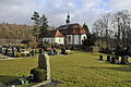
Cemetery with chapel ( location → )

Cemetery chapel with a memorial for war victims

Grave site of the five concentration camp prisoners murdered by members of the Frankenhainer SA

Memorial stone and communal grave for three Frankenhain workers who were killed in the fighting in Gotha in March 1920

War memorial ( Location → )

Railway viaduct over the Gisselgrund


Individual evidence
- ↑ See Fritz Schörnig: Read-told-experienced. From the history of the social struggles and the workers' movement in the Arnstadt and Ilmenau districts. Part I, Arnstadt 1961, p. 115.
- ↑ Quoted from F. Schörnig: Read-told-experienced. Part I, 1961, p. 92.
- ↑ See Fritz Schörnig: Read-told-experienced. From the history of the social struggles and the workers' movement in the Arnstadt and Ilmenau districts. Part III, Arnstadt 1969, p. 189.
- ↑ See Laurenz Demps, Christiaan F. Rüter (ed.): GDR Justice and Nazi Crimes. Collection of East German convictions for Nazi homicide crimes 1945–1999. Volume III, Amsterdam / Munich 2003, p. 67.
- ↑ See L. Demps, CF Rüter: DDR-Justiz. 2003, p. 68.Böttger was sentenced to life imprisonment in August 1963 by the 1st criminal division of the Cottbus District Court. See L. Demps, CF Rüter: GDR Justice. 2003, p. 65.
- ↑ Thuringian Law and Ordinance Gazette No. 14/2018 p. 795 ff. , Accessed on January 1, 2019
- ^ Source for Schwarzburgische and Saxon places: Johann Friedrich Kratzsch : Lexicon of all localities of the German federal states . Naumburg, 1843. Available online from Google Books . Source for Prussian places: Handbook of the Province of Saxony. Magdeburg, 1843. Available online at Google Books
- ^ Michael Rademacher: German administrative history from the unification of the empire in 1871 to the reunification in 1990. Population figures. (Online material for the dissertation, Osnabrück 2006).
- ↑ Population development since 1989 (TLUG) ( Memento of the original from October 29, 2012 in the Internet Archive ) Info: The archive link has been inserted automatically and has not yet been checked. Please check the original and archive link according to the instructions and then remove this notice. (PDF; 18 kB)
- ↑ Municipality of Geratal: Official Journal, Volume 1, No. 12-14 June 2019, accessed on 30 August 2019 .
- ^ Thuringian State Office for Statistics: Elections in Thuringia, mayoral elections in Frankenhain. Retrieved August 30, 2019 .
- ^ Arbeitsgemeinschaft Thüringen eV (Ed.): New Thuringian Wappenbuch. Volume 2, 1998, ISBN 3-9804487-2-X , p. 9.
literature
- Hartmut Ellrich, Theophil Heinke, Karsten Hoerenz: Between Hörsel and Wilder Gera. Wartburg Verlag, Weimar 2005, ISBN 3-86160-167-2 .