Luisenthal
| coat of arms | Germany map | |
|---|---|---|

|
Coordinates: 50 ° 47 ' N , 10 ° 43' E |
|
| Basic data | ||
| State : | Thuringia | |
| County : | Gotha | |
| Fulfilling municipality : | Ohrdruf | |
| Height : | 450 m above sea level NHN | |
| Area : | 30.58 km 2 | |
| Residents: | 1197 (Dec. 31, 2019) | |
| Population density : | 39 inhabitants per km 2 | |
| Postal code : | 99885 | |
| Area code : | 036257 | |
| License plate : | GTH | |
| Community key : | 16 0 67 044 | |
| Address of the municipal administration: |
Marktplatz 1 99885 Ohrdruf |
|
| Website : | ||
| Mayor : | Günter Jobst ( SPD ) | |
| Location of the community Luisenthal in the district of Gotha | ||
Luisenthal is a municipality in the Gotha district in Thuringia . The fulfilling municipality of Luisenthal is the city of Ohrdruf .
geography
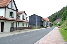
Luisenthal is a street village at an altitude of about 420 to 465 meters long in the valley floor of the Ohra in the Thuringian Forest , above the district of Black Forest is the Ohra dam . To the south, the Black Forest district extends right up to the Rennsteig .
Community structure
Luisenthal consists of the three districts Luisenthal (in the north), Stutzhaus (town center) and Black Forest (in the south, around the castle).
Neighboring places
Neighboring towns in the Gotha district are Graefenhain in the west, the core town of Ohrdruf and Wölfis in the north and Crawinkel in the east. Neighboring towns belonging to the district of Schmalkalden-Meiningen are the town of Oberhof and the town of Oberschönau in the south.
mountains
The highest peaks are the Saukopf ( 869.2 m above sea level ), Alter Berg ( 852 m above sea level ). The Kienberg ( 720.2 m above sea level ), the Streitberg ( 699.1 m above sea level ) and the Fürstenschlag ( 772 m above sea level ) are also important.
Waters
The Ohra , also known locally as Wilder Graben , belongs to the catchment area of the Elbe . The side valleys of the Ohra, Kerngrund , Silbergraben and Großer Weißbach , were flooded when the Ohra was dammed in the lower part. Below the dam, the Siegelbach , the Spitzgraben and the Lehmbach flow as tributaries into the Ohra. The Saukopfmoor is one of the rare Thuringian raised bogs and is therefore a nature reserve . It is located at ( 830 m above sea level ).
history
Luisenthaler Hut
Duke Friedrich III. von Sachsen-Gotha-Altenburg (1699–1772) acquired a copper smelter located south of Ohrdruf at the foot of the Kienberg in the Black Forest district in 1752/53 . The neighboring hammer mill, the Black Forest hammer , refined the ore into copper. The Duke renamed this settlement on October 1, 1753 in honor of his wife Luise Dorothée von Sachsen-Gotha-Altenburg (1710–1767) in Luisenthal . The Black Forest hammer, which was later converted into an iron hammer, was in operation until 1877.
Black Forest
The largest and oldest district is the Black Forest. The settlement Waldsazi - Waldsitz - was mentioned as early as 919. Forest workers, millers, forest farmers and miners lived in it. The place was looked after by the Wölfis parish. A fortification, the Black Forest Castle, was built on a nearby mountain to control Meininger Straße leading to southern Thuringia and Franconia . The castle and town were owned by the Counts of Kevernburg until 1367 . The Thuringian landgraves acquired the castle in 1367 and established the Black Forest office , which now included eight villages as well as mining and hammer works north of the Rennsteig. From 1470 to 1535 the castle belonged to the Counts of Gleichen. In 1664 the village school with a church hall was built at the foot of the Streitberg, looked after by the parishes of Wölfis and Graefenhain. In 1717, Christoph Hähner, the first priest of his own, was welcomed to the community. He brought about the construction of a new church, which was built and consecrated in Stutzhaus in 1719. At the same time, a village school was built in the Black Forest. The extensive forests around the Black Forest were popular hunting grounds for the Gotha dukes. Numerous field and forest place names attest to the former wealth of game. One of the last Thuringian specimens of the brown bear was shot in 1662 by the Stutzhäuser forester Georg Großgebauer am Bärenstein . Up until 1705 other animals were sighted near Tabarz and Georgenthal . A memorial stone on the northern slope of the Großer Böhler commemorates the lynx , which was shot on March 14, 1819 .
On July 1, 1950, the previously independent Black Forest community was incorporated into Stutzhaus.
Stutzhaus
The Stutzhaus forest workers' settlement was built on the banks of the Ohra in the 17th century. As early as 1569, the Duke of Saxe-Coburg-Gotha cleared a forest strip on the banks of the Ohra for clearing and settlement. But the settlement grew only slowly, as the charcoal burners always built their dwellings in the immediate vicinity of the kilns. The Stutzhaus , mentioned for the first time in 1659, was a massive forester's house with a storage shed, in which the forest overseers, so-called forester's servants , had to settle and pay for the charcoal produced using the support . In 1665 the settlement of Stutzhaus consisted of the forester's house, 3 cutting mills, an iron hammer and 5 houses for the forest workers. A brewery and an inn were later added to the Stutzhaus. In 1760 there is the note Länderey is not a hand wide, which aptly describes the conditions in this part of the valley floor, because the trade route also required space. The construction of the Hammerbrücke , which was built between the districts of Stutzhaus and the Black Forest, was also dedicated to her.
On March 1, 1951, the community of Stutzhaus was renamed Luisenthal .
Development in the 19th / 20th century
The expansion of the road to Oberhof and Ohrdruf improved the transport connections. The place was connected to the Gotha-Graefenroda railway in 1876 and became a tourist destination from 1881. Previously, numerous iron hammers and smelters had already ceased operations.
The former Vogt works were significant in the second half of the 20th century under the name HEMAWERK as a specialist company for lifting technology and crane systems. Today it is a production facility of Demag Cranes & Components .
The FDGB recreation home " Adolf Deter " and several children's holiday camps were created for the approximately 10,000 tourists who stayed in Luisenthal each year .
Ohratal barrier
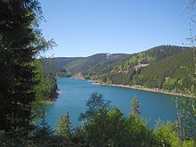
As early as 1916, the Deutsche Reichsbahn tried to acquire water rights in the Ohratal, this lime-poor water was particularly suitable for use in steam locomotives. The rapidly growing industry and the population in Central Thuringia also needed secure drinking water supplies since the 1930s, which is why it was initially decided to build the Lütsche Dam. The Ohra Dam, which was also designed, was delayed due to financing problems; construction began in 1957, but without power plant installations. The dam is the heart of Central Thuringia's drinking water supply companies; it covers the needs of 700,000 residents.
Population development
Development of the population (December 31) :
|
|
|
|
|
- Data source: Thuringian State Office for Statistics
religion
The majority of the population of Luisenthal belongs to the Evangelical Lutheran Church in Thuringia, Superintendentur Ohrdruf.
politics
Municipal council
The municipal council in Luisenthal is made up of 12 councilors.
(As of: local election on May 26, 2019 )
mayor
Günter Jobst (SPD) has been mayor since 1999.
Town twinning
There has been a town partnership with the Hessian town of Karben since 1992 .
Culture and sights
Museums
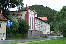
- The Stutzhäuser Brewery Museum is a protected cultural monument in the Gotha district.
Architectural and natural monuments
- The Pirna architect Theodor Quentin built the neo-Gothic Duke Alfred Memorial Church in the Stutzhaus district in 1902/03 instead of the previous building, which was consecrated in 1719 and closed in 1900 due to dilapidation . It was inaugurated on November 3, 1903 in the presence of the dowager Marie , who had supported the building of the church with a donation of 20,000 marks, and numerous guests of honor, including a. her nephew and head of the House of Romanov , Kyrill Vladimirovich Romanov and the English ambassador Lord Goughein. The church is reminiscent of Duke Alfred von Sachsen-Coburg-Gotha , who tried very hard for Luisenthal. A large-scale collection of houses and streets in the Duchy in 1901 had brought in most of the construction costs, 33,000 marks. The groundbreaking ceremony took place on May 3, 1902, the interior was painted in early September 1903, and the altar was built on September 12 and the foundation stone was placed in it a month later. The main organ comes from the workshop of Hugo Böhm from Gotha, it was installed in 1903. The choir organ installed in 1988 comes from the same house.
- In 1988, again from the Böhm workshop, this time by Gerhard Böhm, a new organ was installed, which has five registers , a manual and a pedal .
- On July 4, 1917, the Luisenthal church bells had to be handed in for the manufacture of weapons. Exactly 92 years later to the day, on July 4, 2009, the order was placed to cast three new bronze bells. In the Passau bell foundry Rudolf Perner the casting of these bells took place on November 6th, 2009 in the presence of representatives of the Luisenthaler parish. They bear the names of the Luisenthaler districts: At 450 kilograms, “Black Forest” is the largest and has the slogan on the bell flank: “Praise the gentlemen, my soul!”, The middle one at 245 kilograms is dedicated to “Stutzhaus” and warns: “Peace be mit dich! ”, the smallest weighing 145 kilograms is called“ Luisenthal ”and calls:“ Come on, because everything is ready! ”
At the end of the Second World War, the church suffered considerable damage to the chancel, the roof and the windows from artillery fire. On the 100th anniversary of Duke Alfred's death, on July 30, 2000, the newly designed space in front of the church was handed over by the President of the State Parliament, Christine Lieberknecht .
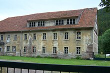
- In the Black Forest district, one encounters houses spread out on steep slopes and the ruins of the Black Forest Castle .
- The school house with the small clock tower is on the Anger.
- The site of the Ohra Dam begins immediately south of the village .
- Luisenthal is particularly rich in natural beauties that can be reached via a well-developed network of hiking trails.
Leisure and sports facilities
The center of Thuringian winter sports is in the neighboring town of Oberhof. On the Streitberg, near the Waldhotel “Berghof”, there is the biathlon facility “Streitbergarena” of the Luisenthaler Sportverein, winter sports department.
Economy and Infrastructure
The Luisenthaler economy consists for the most part of small businesses in the wood and metal industry, crafts and trade. The most important employer is the Thuringian dam administration. Luisenthal has a tourist infrastructure that was already developed in the GDR era. This includes a well-developed network of hiking trails, accommodation, hotels and pensions. The majority of residents now work in the surrounding communities.
traffic
Until December 31, 2006, the B 247 ran through the town and continued south, where it crossed the Rennsteig at an altitude of 830 meters and continued to Oberhof and Schleusingen . Since then, this section has been completely graduated to state road 3247. The closest motorway junctions are Oberhof along the A 71 and the Gotha slip road to the A 4 in the north .
The following bus lines of the regional transport association Gotha serve the place for local passenger transport:
Until the end of 2011, the place had a stop on the Ohratalbahn between Gotha and Gräfenroda .
The closest airport is Erfurt .
literature
- Paul Lehfeld: Black Forest . In: Architectural and art monuments of Thuringia. Duchy of Saxe-Coburg and Gotha. Landrathsamtsiertel Ohrdruf . Publishing house by Gustav Fischer, Jena 1898, p. 115-116 .
- Black Forest. In: Hans Patze , Peter Aufgebauer (Hrsg.): Handbook of the historical sites of Germany . Volume 9: Thuringia (= Kröner's pocket edition . Volume 313). 2nd, improved and supplemented edition. Kröner, Stuttgart 1989, ISBN 3-520-31302-2 , p. 397.
- Ellrich, Heinke, Hoerenz: Between Hörsel and Wilder Gera. The churches of the superintendent in Waltershausen-Ohrdruf . Wartburg, Weimar 2005, ISBN 3-86160-167-2 , p. 60-61 and 122 .
- Luisenthal . In: Horst H. Müller (Hrsg.): Travel Guide Thuringian Forest and peripheral areas . Tourist Verlag, Berlin and Leipzig 1977, p. 456-460 .
- Harald Wetzold: Around the Käfernburg. Streiflichter from the twelve hundred year church history of the church district Ohrdruf . In: Literature of the press office of the Evangelical Lutheran Church in Thuringia . Wartburg Verlag Max Keßler, Jena 1983, p. 66-69 .
Web links
Individual evidence
- ^ Population of the municipalities from the Thuringian State Office for Statistics ( help on this ).
- ↑ a b Thuringian Land Survey Office TK25 - sheet 5230 Oberhof . Erfurt 2008, ISBN 978-3-86140-403-3 .
- ↑ Wolfgang Zimmermann: Small nature guide Thuringian Forest . In: Museums of the City of Gotha (Hrsg.): Treatises and reports of the Museum of Nature Gotha . Issue 9. August Bebel printing house, Gotha 1990, p. 31-39 .
- ↑ municipal elections Luisenthal 2014. In: wahlen.thueringen.de. Retrieved December 13, 2019 .
- ↑ a b Local council election Luisenthal 2019. In: wahlen.thueringen.de. Retrieved December 13, 2019 .
- ↑ The Brewery Museum
- ↑ Act of Creation in Passau . In: Thüringische Landeszeitung , November 9, 2009, local page Gotha
- ^ Thuringian State Office for Road Construction, Road Map Thuringia. 1: 200,000 , Erfurt 2005
- ^ Regional transport company Gotha. Timetable tables. (No longer available online.) Archived from the original on June 5, 2008 ; Retrieved June 29, 2009 . Info: The archive link was inserted automatically and has not yet been checked. Please check the original and archive link according to the instructions and then remove this notice.


