Black Forest Castle
| Black Forest Castle | ||
|---|---|---|
|
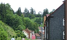
General view of the Black Forest Castle (2009) |
||
| Alternative name (s): | Kävernburg, Käfernburg, Kevernburg | |
| Creation time : | around 1250 | |
| Castle type : | Höhenburg, spur location | |
| Conservation status: | Tower ruins, neck ditch, wall remains | |
| Standing position : | Count | |
| Construction: | Quarry stone masonry | |
| Place: | Luisenthal | |
| Geographical location | 50 ° 46 '6.9 " N , 10 ° 43' 53.5" E | |
| Height: | 519 m above sea level NN | |
|
|
||
The Black Forest Castle was a high medieval fortification on a narrow mountain ridge above the Black Forest district in the Thuringian Forest . It initially served to monitor an important military and trade route that led across the Thuringian Forest near Oberhof and was also used as an administrative center (Black Forest Office) from the 14th century.
location
The castle site of the Spornburg is located in the center of the Black Forest district of the municipality Luisenthal on a mountain spur ( 519 m above sea level ), about 60 meters above the valley floor of the Ohra .
description
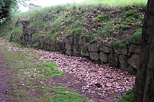
The Black Forest Castle is a section castle , it was protected by steep slopes to the north, west and south and still recognizable ditches and ramparts. The facility extends over a length of about 250 meters and 20 to 40 meters wide on the crest of the narrow mountain spur, which extends from the Turmberg ( 659.2 m above sea level ) in a westerly direction into the Ohratal. Access was via the ravine that can still be seen in the east and initially led over a neck ditch sunk into the rock (this is still clearly recognizable and runs in an arched manner, it was about 5 meters deep and wide), it was taken from the castle tower to the west (today's residual height about 20 meters). On the north side of this neck ditch there is an explanatory board for the Heimatverein, here you can still clearly see the course of a protective wall when looking towards the location, which made the castle complex at this point inaccessible. Little traces of the castle's buildings and fortifications have survived. In the middle section of the castle you can see on the south side a remnant of the wall about 1 meter high and still about 10 meters long on the hiking trail. Further trenches subdivide the western part of the castle in which the residential and farm buildings as well as the administration were housed.
history
An old pass road led through the Luisenthaler area towards Oberhof and Meiningen . It was first mentioned in a document in 1290, when the castle was named "castrum Swarzenwalt" at the Reichstag in Erfurt . Until 1302 the castle with an associated farm in the valley belonged to the Counts of Kevernburg , was briefly acquired by the Counts of Orlamünde , then by the Counts of Schwarzburg . Around 1367 the city of Erfurt tried hard to buy the castle, it wanted to secure one of its most important trade routes to Franconia and save customs and road money. This project failed and the castle fell to the Thuringian landgraves . The Wettins established a bailiwick in the castle and thus established the Black Forest office , it included the villages of Black Forest and Stutzhaus - today Luisenthal, Oberhof, Zella St. Blasi and Mehlis - today Zella-Mehlis , as well as hunting lodges, mines, mills, huts and Logging places. The office was only moved to Zella Sankt Blasii, the main town of the office, in 1642. After the Thirty Years War , the castle ruins were abandoned and served as a quarry for the Black Forest settlement, which has now expanded to include the castle hill. With the construction of the railway line to Luisenthal, tourism began around 1920, for this purpose the ruins became interesting again and made accessible through the creation of walking paths and viewpoints.
Name interpretation
The name Black Forest is to be seen as early evidence of the coniferous forest (spruce, fir) that was still predominant here in the late Middle Ages.
status
The castle site is a protected ground monument . The area in question is used for tourism and forestry.
Others
In the western part of the castle a small memorial was erected after 1870, it commemorates the Franco-German War .
literature
- Michael Köhler: "Black Forest, Käfernburg" - Thuringian castles and fortified prehistoric and early historical living spaces . Jenzig-Verlag, Jena 2001, ISBN 3-910141-43-9 , p. 230 .
- Thomas Bienert: "Käfernburg ruins, also Black Forest" - Medieval castles in Thuringia . Wartberg Verlag, Gudensberg-Gleichen 2000, ISBN 3-86134-631-1 , p. 80-81 .
- Paul Lehfeld: «Black Forest» . In: Architectural and art monuments of Thuringia. Duchy of Saxe-Coburg and Gotha. Landrathsamtsiertel Ohrdruf . Publishing house by Gustav Fischer, Jena 1898, p. 115-116 .
Web links
Individual evidence
- ↑ Thuringian Land Surveying Office TK25 - sheet 5230 Oberhof . Erfurt 2008, ISBN 978-3-86140-403-3 .
- ^ Luise Gerbing : The field names of the Duchy of Gotha and the forest names of the Thuringian Forest between the Weinstrasse in the west and the Schorte (sluice) in the east; on behalf of the Association for Thuringian History and Archeology. and ed. by Luise Gerbing . Jena G. Fischer, 1910 ( archive.org [accessed May 23, 2020]).


