
Tröchtelborn
| coat of arms | Germany map | |
|---|---|---|

|
Coordinates: 51 ° 0 ' N , 10 ° 49' E |
|
| Basic data | ||
| State : | Thuringia | |
| County : | Gotha | |
| Management Community : | Nesseaue | |
| Height : | 310 m above sea level NHN | |
| Area : | 5.68 km 2 | |
| Residents: | 309 (Dec. 31, 2019) | |
| Population density : | 54 inhabitants per km 2 | |
| Postal code : | 99869 | |
| Area code : | 036258 | |
| License plate : | GTH | |
| Community key : | 16 0 67 068 | |
| Address of the municipal administration: |
Dr.-Külz-Str. 4 99869 Friemar |
|
| Website : | ||
| Mayor : | Hartmut Brand ( CDU ) | |
| Location of the community Tröchtelborn in the district of Gotha | ||
  |
||


Tröchtelborn is a municipality in the administrative community of Nesseaue in the Thuringian district of Gotha .
geography
Tröchtelborn is located in the valley between the Fahner Heights in the north and the seamounts in the southwest, on a historic connecting road from Erfurt to Gotha. The neighboring towns are (clockwise from Bienstädt in the northeast) Bienstädt , Zimmersupra , Nottleben , Pferdeleben , Friemar and Molschleben .
history
Tröchtelborn is located in an old Germanic , previously Celtic settlement area. The place name is also of Germanic origin (born = source). It was first mentioned in a document from 750-779. The city of Erfurt acquired Tröchtelborn in 1351 from the fief of the Counts of Schwarzburg and incorporated it into the Nottleben Bailiwick . From 1706 it was administered by the Alach Office. In 1802 he came with the Erfurt area to Prussia and between 1807 and 1813 to the French principality of Erfurt . With the Congress of Vienna the place came back to Prussia in 1815 and in 1816 it was affiliated to the Erfurt district in the Prussian province of Saxony .
In April 1945 Tröchtelborn was shot at by American artillery at night . The church was badly damaged, as were a number of residential and farm buildings. There were no losses among the population who had fled into the cellars. At the beginning of July 1945 the Americans handed Tröchtelborn, like all of Thuringia, over to the Red Army . It became part of the Soviet occupation zone and, in 1949, of the GDR.
After the fall of the Berlin Wall and reunification, urgently needed restoration work was carried out on the church and residential buildings. The largely preserved village image became appealing again, the meadow was also renewed and became the center of the village again. Club life was revived and a local museum was set up.
In 2017. Team volunteers was a German from a fighter aircraft of the type Focke-Wulf Fw 190 unearthed at Tröchtelborn that was probably shot down on April 5 1945th The remains of the pilot, whose identity remained unclear, were buried in the Gotha cemetery.
Population development
Development of the population (December 31) :
|
|
|
|
|
- Data source: Thuringian State Office for Statistics
mayor
Hartmut Brand (CDU) was elected mayor in 1999 and was confirmed in office in 2004, 2010 and 2016.
Attractions
- The St. Bonifatius Church is a hall church with a wooden barrel and a choir closed on three sides from the years 1603 to 1605.
- The half-timbered rectory with an idyllic garden is not far from the church. From 1610 to 1621 it was the residence and official residence of Michael Altenburg, pastor and composer of the early Baroque. The Altenburg living room, a plank room, serves as a winter church, for meetings and celebrations.
- The local history museum "Steinerthof" in Tröchtelborn was founded in 1996. A former small farm from the 19th century with a barn, stables and house has been reconstructed using many of the original materials, such as the blue woad ( indigo ), brick slabs and limestone paving .

church

Side entrance of the church with coat of arms
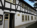
Rectory in Tröchtelborn
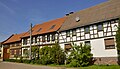
Half-timbered house


Sons and daughters of the place
- Johannes Dinckel (born June 23, 1545 - † December 24, 1601 in Coburg ), Protestant theologian
- Georg Christian Apel (born November 21, 1775 in Tröchtelborn, † August 31, 1841 in Kiel ), organist and composer
Other personalities associated with the place
- Michael Altenburg (* 1584 in Alach , † 1640 in Erfurt ), pastor (in Tröchtelborn from 1610 to 1621), cantor and important composer of his time
Club and community life
- Homeland and cultural association
- Fire Brigade Association Tröchtelborn eV
- Tröbo eV
Individual evidence
- ^ Population of the municipalities from the Thuringian State Office for Statistics ( help on this ).
- ↑ Tröchtelborn on www.thueringen-universal.de
- ^ Frank Thadeusz: Hobby archaeologist Uwe Benkel digs up crashed fighter pilots. In: Spiegel Online . August 31, 2017, accessed May 15, 2020 .
- ↑ http://wahlen.thueringen.de/datenbank/wahl1/wahl.asp?wahlart=BM&wJahr=0000&zeigeErg=GEM&auswertung=1&wknr=067&gemnr=67068&terrKrs=&gemteil=000&buchstabe=&Langname=&wahlvorschlag=&sort=&druck=&XLS=&anzahlH=- 6 & Non_existing = & x_vollbildDatteil = & optik = & aktuell = & ShowLand = & ShowWK = & ShowPart = & w_date = 05.06.2016
- ^ Rochus von Liliencron: Apel, Georg Christian . In: Allgemeine Deutsche Biographie (ADB). Volume 1, Duncker & Humblot, Leipzig 1875, p. 500.
Web links
Bad Tabarz | Bienstädt | Dachwig | Döllstädt | Three of a kind | Emleben | Eschenbergen | Friedrichroda | Friemar | Georgenthal | Gierstädt | Gotha | Großfahner | Manor | Earpiece | Luisenthal | Molschleben | Nesse-Apfelstädt | Nessetal | Emergency life | Ohrdruf | Horse life | Schwabhausen | Sonneborn | Tambach-Dietharz | Tonna | Tröchtelborn | Tüttleben | Waltershausen | Room supra