
Lütsche-Flößgraben

The Lütsche Flößgraben (also known as the Alter Flößgraben ) was a rafting ditch created for rafting wood in the Thuringian Forest , which can now be used as a hiking trail. It is located in an area north of the middle Rennsteig , which is bounded by the municipalities of Oberhof , Geratal and Luisenthal .
history
Until the 17th century, the wood from the Duchy of Gotha was floated on the Gera for a fee through the Schwarzburg area, as Thuringia was territorially strongly divided at that time. At the end of the 17th century, the Graflich-Schwarzburgisch-Arnstädtische Kammer increased the fees so drastically that the then head of the Gotha rafts implemented the plan of his miner Georg Christoph von Utterodt to build a raft ditch in the Gotha area.
From 1691 to 1702, the main section of the Flößgraben was built, which led from the Lütsche -bach at the Langengrundteich (the site of today's campground at the Lütsche-Talsperre ) along the slopes of the Borzelberg , Steigerberg and Eisenberg . Then it stretches along the Rumpelberg , above Friedrichsanfang (a current district of Ohrdruf ), along the Kienberg to Luisenthal, where it flows into the Ohra . The wood was then rafted through the apple city to Erfurt.
In 1702 the raft ditch was used for the first time.
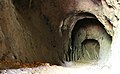
A few years later the raft ditch was extended “backwards” to the Kehltal in order to develop new forest areas. The raft ditch should run along exactly the same level as the burned-out stone , so a 38 m long, on average 2.30 m high and 2.20 m wide tunnel had to be blasted bit by bit in the porphyry rock by alternately using fire and ice-cold water - the Burned out stone. The construction of the boarded trench with the help of the local population was also very tedious because the raft ditch mostly ran along the steep slope, so that the valley side had to be dammed with tree trunks.

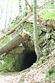
West entrance of the burned-out stone
Internally
outlook
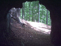
East entrance of the Burned Stone


For rafting, the wood was first transported to the Kehltalsteich after the snow melted, then the locks were opened and the rafted goods took their way along the slope, through the burned-out stone , further around the Tragberg , to the Sieglitzteich , past the Sieglitzkopf and the Hohe Warte Lütschegrund and from there on to the first section. The population of the neighboring villages had to stand along the ditch and use long hooks to prevent the up to 4 m long logs from getting caught. The logs were pulled through the burnt stone by lumberjacks ; this work was considered particularly hard because the men had to work in the water.
However, water repeatedly seeped through the wooden seals and the damming became too expensive, so that draining was stopped after 17 years and only 11 uses. The costs of 50,000 thalers for construction and repairs could therefore not be covered by transporting only around 40,000–50,000 m³ of wood.
Todays situation

Today there is a 23 km long hiking trail in and along the former Flößgraben. Some traces of the raft ditch are still clearly visible, such as the excavation of the path. A highlight on the Flößgraben is the burned-out stone, through whose dark tunnel the hiking trail still leads today.
Since 1980, one held annually in Gräfenroda fun run under the name Flößgrabenlauf place whose route includes large parts of the Flößgrabens.
During the construction of the Thuringian Forest Autobahn, the Kehltal air exchange center of the Rennsteig tunnel was built near the former beginning of the Lütsche Flößgraben on the Kehltalsteich. The term raft ditch for the air exchange center at the southern end of the tunnel refers to another raft ditch on the southern slope of the Thuringian Forest.
literature
- Karl Immel: A hike on the Lütsche-Flößgraben . In sources on the history of the village of Lütsche , 2nd edition, Thüringer Chronik-Verlag, HE Müllerott, Arnstadt 1994/99
- Lutz Gebhardt: hiking map Gehlberg and Graefenroda , 3rd edition 2001, publisher green heart
- Brockhaus hiking booklet No. 127 Oberhof Gehlberg , 2nd edition 1972, Halberstadt
Web links
Coordinates: 50 ° 44 ′ 13 ″ N , 10 ° 46 ′ 3 ″ E