Breitenheerda
|
Breitenheerda
City of Rudolstadt
Coordinates: 50 ° 47 ′ 1 ″ N , 11 ° 12 ′ 11 ″ E
|
|
|---|---|
| Height : | 414 (410-415) m |
| Residents : | 170 |
| Incorporation : | January 1, 1997 |
| Incorporated into: | Remda Teichel |
| Postal code : | 07407 |
| Area code : | 036744 |
|
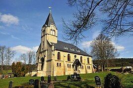
Evangelical village church (built 1896)
|
|

Breitenheerda is a district of the city of Rudolstadt in the Saalfeld-Rudolstadt district in Thuringia .
geography
Breitenheerda is located on the northeast slope of the Großer Kalms and between the end of the Österödaer rift and on the western edge of the Tannröder forest. The hamlet of Tännich is part of Breitenheerda. Neighboring towns are Oesteröda and Dienstedt .
history
In 1294 the place was first mentioned in a document. In October 1342 hostilities broke out between Count Günther the XXI. from Schwarzburg-Blankenburg . He was with the main power in Arnstadt and quarreled with the Thuringian landgrave. Brushwood and foot servants sacked villages, including Breitenheerda and the Edelhof. The situation in the area was poor, according to the Schwarzburg Chronicle.
The village belonged to Schwarzburg-Rudolstadt until 1920 and then to the Rudolstadt district .
In 1923 Otto Glaeser managed the estate with 191 hectares. After the Second World War, this business was subject to the typical development of agriculture in the Soviet Zone and GDR.
An NVA missile unit was stationed on the Kalm . On January 1, 1997, Breitenheerda, the cities of Remda and Teichel and nine other places formed the new city of Remda-Teichel . On January 1, 2019, Breitenheerda became a district of Rudolstadt as part of the incorporation of Remda-Teichel.
Economy and Transport
Breitenheerda is an agricultural place. The state road runs through the village from Arnstadt via Dienstedt and Remda to Rudolstadt. The traffic, the environment and also the economy were influenced by the deployment of the missile unit at that time.
Attractions
The Protestant village church was built in the neo-Romanesque style as a hall church in 1896. The building made of stone blocks stands on the foundations of the medieval predecessor building. The church was last renovated in 2001 with the support of the German Foundation for Monument Protection .
Web links
- Brief portrait of Breitenheerda on the website of the city of Remda-Teichel
Individual evidence
- ↑ Breitenheerda on the website of the municipality of Remda-Teichel.Retrieved on March 30, 2015
- ^ Wolfgang Kahl : First mention of Thuringian towns and villages. A manual . 5th, improved and considerably enlarged edition. Rockstuhl, Bad Langensalza 2010, ISBN 978-3-86777-202-0 .
- ↑ Wilfried Warsitzka: The Thuringian Landgrave. Dr. Bussert & Stadeler, Jena 2003, ISBN 3-932906-22-5 , pp. 300-301.
- ^ Jürgen Gruhle: Land Reform Black Book. 2011, accessed on May 20, 2011 (overview by federal states and locations on expropriation measures after the end of World War II as part of the land reform).
- ^ StBA: Changes in the municipalities, see 1997
- ↑ Thuringian Law and Ordinance Gazette No. 14/2018 p. 795 ff. , Accessed on January 20, 2019
- ^ Ingrid Scheurmann, Katja Hoffmann: Sacral buildings (= preserve cultural heritage. Funding projects of the German Foundation for Monument Protection. Vol. 1). Published by the German Foundation for Monument Protection. Monuments, Bonn 2001, ISBN 3-935208-10-3 , p. 314.
