Höllenberg (Südheide)
| Hell Mountain | ||
|---|---|---|
| height | 93 m above sea level NHN | |
| location | at Behningen ; Districts Heidekreis and Rotenburg , Lower Saxony ( Germany ) | |
| Mountains | Neuenkirchen terminal moraine , Südheide | |
| Coordinates | 53 ° 0 '6 " N , 9 ° 39' 29" E | |
|
|
||
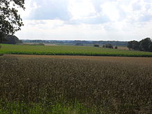
The Höllenberg is 93 m above sea level. NHN high elevation of the Walsroder Lehmgeest in the outer west of the Südheide , part of the Lüneburg Heath . It is located near Behningen in the Lower Saxony districts of Heidekreis and Rotenburg . A Schlageter monument stands on the elevation .
geography
location
The Höllenberg rises on the border of the city of Visselhövede (district of Rotenburg) in the southwest and the municipality of Neuenkirchen (district of Heidekreis) in the northeast. Its summit is about 1 km west of Behningen (zu Neuenkirchen) and 1.6 km south of Drögenbostel and 2.7 km east-southeast of Hiddingen (both to Visselhövede). About 5 km northwest of the gently sloping Höllenberg rises the Rodau and on its southern flank the Warnau . 2.8 km (as the crow flies ) east-northeast of the elevation is the Stichter See .
Natural allocation
The Höllenberg belongs to the natural space main unit group Lüneburg Heath (No. 64), in the main unit Südheide (641) and in the subunit Walsroder Lehmgeest (641.0) to the natural area Neuenkirchener terminal moraine (641.04).
Protected areas
On the Höllenberg which are protected landscape areas Höllenberg ( CDDA -No 321728;. 1940 noted), the reported variously as 5 or 5.73 ha is large, in the north and environment of Hell Mountain (CDDA No. 325290;. 1941; 4 hectares) in South.
Schlageter monument
There is a Schlageter monument on the Höllenberg , which was inaugurated in 1926. A controversy arose around this in 2010, because the swastika on the memorial was first removed and then re-attached. The state security switches on.
Traffic and walking
North-west past the Höllenberg leads from Neuenkirchen through Drögenbostel and Hiddingen to Visselhövede the state road 171 and south-east runs from Neuenkirchen to Behningen and then further south-west the district road 18. The summit of the elevation can be reached, for example, coming from the north via a dirt road . The Hermann Billung hiking trail leads over there .
Individual evidence
- ↑ a b c Map services of the Federal Agency for Nature Conservation ( information )
- ^ Sofie Meisel: Geographical land survey: The natural spatial units on sheet 57 Hamburg-Süd. Federal Institute for Regional Studies, Bad Godesberg 1964. → Online map (PDF; 4.4 MB)
- ↑ Landscape protection areas in the district of Rotenburg (Wümme) ( Memento of the original from April 19, 2014 in the Internet Archive ) Info: The archive link was inserted automatically and has not yet been checked. Please check the original and archive link according to the instructions and then remove this notice. , As of April 10, 2014, on lk-row.de
- ↑ The Schlageter Memorial on the Höllenberg - Past times. July 24, 2015, accessed September 7, 2017 .
- ↑ State security intervenes. November 24, 2010, accessed September 7, 2017 .


