
Örtze
| Örtze | ||
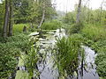
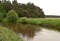
 The Örtze near Hermannsburg |
||
| Data | ||
| Water code | EN : 486 | |
| location | Lower Saxony , Germany | |
| River system | Weser | |
| Drain over | Aller → Weser → North Sea | |
| source | north of Munster in the Große Heide (federal forest robbery chamber) 53 ° 2 ′ 16 ″ N , 10 ° 6 ′ 23 ″ E |
|
| Source height | 81 m above sea level NHN | |
| muzzle | in Aller southeast of Winsen Coordinates: 52 ° 40 '17 " N , 9 ° 55' 54" E 52 ° 40 '17 " N , 9 ° 55' 54" E |
|
| Mouth height | 30 m above sea level NHN | |
| Height difference | 51 m | |
| Bottom slope | 0.82 ‰ | |
| length | 62 km | |
| Catchment area | 760 km² | |
| Discharge at the Feuerschützenborstel A Eo gauge : 738 km² Location: 13.6 km above the mouth |
NNQ (07/12/1976) MNQ 1961/2014 MQ 1961/2014 Mq 1961/2014 MHQ 1961/2014 HHQ (07/20/2002) |
2.28 m³ / s 3.1 m³ / s 5.88 m³ / s 8 l / (s km²) 22.2 m³ / s 40.7 m³ / s |
| Outflow A Eo : 760 km² at the mouth |
MNQ MQ Mq |
3.15 m³ / s 6.03 m³ / s 7.9 l / (s km²) |
| Left tributaries | Small ortze ; Landwehrbach (with upper reaches Schmarbeck and Sothrieth ), Weesener Bach , Angelbach, | |
| Right tributaries | Ilster , Wietze , Brunau , Brandenbach, Hasselbach, Mühlenbach, Rollbach | |
| Small towns | Munster , Bergen | |
| Communities | Faßberg , Müden (Örtze) , Südheide and Winsen (Aller) | |
The Örtze is a river in Lower Saxony that rises at the Munster Nord military training area in the Große Heide (federal forest robbery chamber ) and flows into the Aller after 62 kilometers southeast of Winsen . With a water flow of a good 6 m³ / s, it is their largest right tributary.
origin


The Örtze essentially follows a wide glacial valley that was cut 20 to 50 meters deep into the undulating plateaus of the southern Lüneburg Heath by meltwater from the Saale Ice Age inland ice around 150,000 years ago . The edge of the ice roughly coincided with the northeastern edge of the Örtze catchment area . The upper Örtze has cut its own, much smaller valley into the sand areas and the approximately four kilometers wide flat valley floor of the straight glacial valley.
The area of origin of the Örtze lies with several spring swamps on the site of the Munster-Nord military training area . In order to intercept turbid matter and sediments that are washed away from the armored training areas with little vegetation in heavy rain, the four Muno lakes, one behind the other, were created at the Ortze. In addition, another reservoir was created on the Ilster , the actual main source river of the Örtze. The name Ilster is reminiscent of a large village that partly had to give way to the Munster-Nord military training area. As the largest river in the Südheide, the Örtze drains its central part, between the somewhat longer Böhme in the west and the Ise in the east, and has a relatively steep gradient. In the middle of the lower reaches, the current is about 0.71 meters per second, the water depth 50 cm to two meters. It is a so-called summer cold Heidebach.
course

The Örtze flows in its original natural river bed in a southerly direction, first past Breloh, a district of the city of Munster and then directly through the city of Munster (the most important military location in Northern Germany). The river was dammed here in the 17th century in order to operate a flour mill. West of the town of Dethlingen, it crosses the federal road 71 and then flows on the eastern edge of the Munster-Süd military training area to Kreutzen , another district of Munster. The river meanders here in the military area in its original, natural bed through partly swampy moorland and swamp forests . The Kleine Örtze , which rises north of Oerrel, flows to the south-west of Kreutzen from the left . Before it was renatured, its upper course served as a drainage ditch for the former raised bog, which has now been reforested. Almost its entire length of the narrow valley was declared a nature reserve in 1993 . In a southerly direction, the Örtze comes to Poitzen and Müden . The Landwehrbach flows to the north of Müden; on the upper reaches of which Schmarbeck is bordered to the north by the Faßberg military airfield , on the other upper course of which Sothrieth there are numerous former kieselguhr pits on both sides .
In the south-west of Müden, the Wietze joins from the right , giving the heath place its name. The Wietze is its largest tributary . It rises between Soltau and Munster, and with the Aue , which is again its largest tributary, it exceeds the Örtze by a good five kilometers in length. It flows past the original Rieselwiesen to Baven , where the Brunau joins from the right and on to Hermannsburg (made famous by the Hermannsburg Mission ). In the north of Hermannsburg comes the Weesener Bach from the left . The Örtze then continues south to Oldendorf and Eversen . Before Eversen, the Mühlenbach, which comes from Sülze , joins from the right . The Sülzer Saline was operated in this place from the 14th to the 19th century . In the further course the Örtze comes to Wolthausen . Here a mill weir blocks the course of the river. In Wolthausen, the river crosses federal highway 3 . Behind Wolthausen, the Örtze Canal branches off to the right. In the east of Winsen (Aller) the Örtze flows into the Aller .
The tributaries of the Örtze are: Ilster, Kleine Örtze, Wietze, Schmarbeck and Sothrieth (together as Landwehrbach flow into the Örtze), Brunau, Weesener Bach, Brandenbach, Hasselbach, Angelbach, Mühlenbach and Rollbach.
Hydrology
Since the Örtze has been largely spared from expansion measures, a natural habitat has been preserved here. The water quality has consistently the water quality class II: moderately polluted ( betamesosaprob ). Black alders , pines and spruces on the shore provide shade. This means that the water stays cool even in summer and the oxygen content is high. The Örtze is relatively poor in nutrients, it has a low exposure to nitrates and heavy metals. Their course is partly meandering and rich in structure and offers hiding places and spawning opportunities with individual steep banks, depressions, gravel and sand banks .
The treated wastewater from the central sewage treatment plants in Munster, Hermannsburg and Eversen is fed directly into the Örtze. The Wietzendorf and Faßberg systems lead them indirectly via the Wietze and Landwehrbach to the Örtze. The Fassberg sewage treatment plant also receives the wastewater from the Unterlüß community via a pressure pipeline .
fauna and Flora
_(4).JPG)

In the upper and middle reaches of the river you can find the alternating milfoil (Myriophyllum alterniflorum), which is listed in Lower Saxony on the Red List of Endangered Species as "critically endangered" (hazard category 2). You can also find the shield water crowfoot (Ranunculus peltatus) and the hook water star (Callitriche hamulata). In the middle reaches the flooding water cockfoot (Ranunculus fluitans) and the simple hedgehog (Sparganium emersum) are common.
In the wet meadows of the river valley, some rare plant species have survived. One can find, for example, nor the Broad Marsh Orchid (Dactylorhiza majalis), Spotted Orchid (Dactylorhiza maculata), Small two-bladed or heart Two sheet (Listera cordata), marsh gentian (Gentiana pneumonanthe), Forest lousewort (Pedicularis sylvatica) and marsh marigolds ( Caltha palustris). All plants protected according to the Federal Species Protection Ordinance . On the Red Lists these are classified as "endangered" or in some cases "highly endangered". Snake knot (Bistorta officinalis), cuckoo's light carnations (Lychnis flos-cuculi), spicy, creeping and burning buttercups (Ranunculus), chickweed (Stellaria alsine), speedwell (Veronica), gundermann (Glechoma hederacea), grow here , Creeping gunnels (Ajuga reptans), swamp forget-me-nots (Myosotis scorpioides) and bald lady's mantle (Alchemilla glabra). Different types of sedges, such as swamp sedge (Carex acutiformis), slim sedge (Carex acuta), meadow sedge (Carex nigra), roller sedge (Carex elongata) and beak sedge (Carex rostrata) have settled. The yellow iris (Iris pseudacorus) blooms on the bank .
The following fish and animals are present: eel ( Anguilla anguilla ) and eel caterpillar or burbot ( Lota lota ), grayling ( Thymallus thymallus ), brown trout ( Salmo trutta forma fario ), brown lamprey ( Lampreta planeri ), bream or lead ( Abramis brama ), minnow ( Phoxinus phoxinus ), perch ( Perca fluviatilis ), gudgeon or Greßling ( gobio gobio ), pike ( Esox lucius ), bullhead or bullhead ( Cottus gobio ), roach or roach ( leuciscus rutilus ), rudd ( Scardinius erytrophthalmus ) and loach ( Contis taenia ).
The endangered otter , which is worth protecting , is one of the main areas of distribution in Lower Saxony. The kingfisher also lives here. The corncrake adheres temporarily to the extensively used fallow meadows in the river valley. The harvest mouse (Micromys minutus) can be found on the unmanaged, natural wet meadow areas . The grassland serves as a feeding habitat for the white stork (Ciconia ciconia) . The American crayfish ( Kamberkrebs ) is also spreading strongly in the Örtze. Due to the crayfish plague that he brought in, against which he is immune, he displaces the original crustacean fauna. The European crayfish (Astacus astacus) has been at home again in small numbers for several years.
At running waters typical species of dragonflies that come Beautiful Demoiselle ( Calopteryx virgo ), the golden-ringed dragonfly ( Cordulegaster boltoni ), the Common Clubtail ( Gomphus vulgatissimus ), the Green Clubtail ( Ophiogomphus serpentinus / Cecilia ) and the Small Emerald Damselfly ( Lestes virens ) ago.
The beaver has settled in the Örtze. In the spring of 2016, traces of a beaver feeding on some willows on the banks of the river were discovered for the first time . In the meantime, the beaver castle has also been discovered on a pond near the Örtze.
Watermills, weirs and fishing routes
Salmon fishing has been documented in the Örtze since 1766. The last salmon were caught here in 1935 . Since 1982, attempts have been made to reintroduce them with a new stock of salmon. The necessary undisturbed migration of small animals and fish upstream is interrupted and prevented by weirs. The spawning migration of brown trout and salmon is also prevented.
Munster watermill


The watermill, which was first mentioned in 1556, is located in the center of Munster. Presumably at the beginning of the 17th century, it received an undershot water wheel with a goiter channel and a grinding mill. Hans Poitzmann is known by name as the first miller. From 1784 a Peter Gerdau continued to run the mill, which he handed over to his son in 1820. This built in 1820 in addition a shot transition an oil mill and a second water wheel. In 1847 the mill was sold due to excessive indebtedness. There was always trouble with the meadow owners on the Örtze because the mill pond in Munster was dammed too high. In 1919 a miller died when his jacket got caught in the gears of the mill gear. After 1945 the Örtze became so silted up by the sewage from the military training area that the operation of a water wheel was no longer possible and was stopped in 1949. The grist mill received an electric drive. In 1968 the mill pond was cleared of alluvial mud. The planned installation of a turbine failed due to the low discharge values in the Örtze. In 1975 the city of Munster acquired the mill and the damming right approved under water law . In 1987/88 a renovation was carried out. A new undershot wooden water wheel was installed, which was replaced by a steel water wheel in 2011. This has a diameter of 5 m, a blade width of 1 m and has 48 blades. The speed is 3–25 / min. Two functioning grinders (meal and flour) and a sifter can be visited today and are used on the grinding and baking days. The use of a power generator is also being planned again.
Sultinger mill


The village of Sältingen was on the site of the Munster-Süd military training area . As part of the expansion of the square, it had to give way in 1937. For security reasons, all buildings, including the school in the village, were demolished in 1956. The “ Sältinger Mühle ” was the only building that remained , which was powered by a wooden water wheel until 1900 . Until the First World War , the Winkelmann family, whose farm was first mentioned in a document in 1381 and had been owned by the family for 300 years, also ran the watermill on the Örtze . In 1934 a water turbine was installed here. In 2008, today's weir system was built with a storage height of 1.90 m and in 2009 a new hydropower plant was put into operation. The water wheel with a diameter of 1.80 m has a speed of 11 / min. The water flow is 225 l / s. The system has an output of 4 kW , it feeds around 8,700 kWh into the power grid annually .
In 1998/99 a flat bottom slid with flood was built in the area of the Sältinger Mühle to give fish and other aquatic life a chance to move upstream. The bottom width is 0.50 m and the bottom depth 0.25 m. With a gradient of 1%, the water discharge is 0.25 m³ / s.
Mill and fish path in Müden


It is documented that as early as 1438 there was a grain mill on the Örtze , which was powered by water power . In 1465 "Ole Müller", owner of Müllerhof Müden No. 1, received the sovereign milling privilege from Duke Wilhelm I of Braunschweig-Lüneburg . To 1621, the flour mill to a likewise by a was water wheel driven, sawmill expanded, which was moved to the other side of the Örtze, today the multi-storey mill building from 1913 stands at the. During the construction of this mill building, a Francis shaft turbine with an output of 45 hp was installed to drive the flour mill. This turbine still exists today, but is no longer in operation because of the high noise level. The sawmill also received a Francis turbine with an output of 7 kW . The sawmill was in operation until the 1950s, the grain mill was in operation until 1965. After that, the old mill building served as a storage building until 1973. The building was renovated from 1993 to 1997 and today it houses the tourist information office, a library, a wedding room and exhibition rooms. Of the two Francis shaft turbines installed in an adjoining building, the smaller one of 7 kW is back in operation today and generates around 100–130 kWh of electricity per day via a generator . This is primarily used for self-sufficiency in the mill building. The excess electricity is fed into the public grid.
Around the weir at the mill in Müden , a circulating channel was created in the summer of 1995, which again enables the upstream stretch of water to flow.
Weir in Wolthausen

The weir in Wolthausen was the last obstacle for the fish and small animals moving upstream until August 2012. From the 16th century to 1960 the Örtze drove the waterwheel of a grain mill here . Today a Francis turbine with a generator runs next to the water wheel to generate electricity . In the meantime, a fish ladder with ten steps, around 1 m wide and around 17 m long, with a total fall height of 1.20 m, also suitable for invertebrates , has been created. The lower water authority of the district of Celle approved the structure at the end of 2010 in accordance with Section 68 of the Water Resources Act (WHG). The flow rate is 140 to 300 l / s at a flow velocity of approx. 1.16 m / s. The total cost was around 35,000 euros. BINGO! - the environmental lottery of the North German Broadcasting Corporation is funding the project with an amount of 15,000 euros.
- Pictures of the river
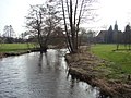
Natural course of the river near Sältingen
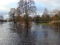
Örtzepark in Hermannsburg, the Örtze regularly burst its banks in spring
Örtzepark in Hermannsburg at normal water level

Örtze in the spruce forest near Hermannsburg
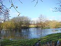
Flooded Örtzewiesen

Örtzewiesen near Oldendorf
In the sandy and flat bed just before the confluence with the Aller

Muzzle into the Aller (left the Örtze)

.jpg)
.jpg)


.jpg)


Rieselwiesenwirtschaft
Until the 1950s, the meadows in the Örtze floodplain were irrigated according to the principle of the Lüneburg ridge structure , also known as the Suderburger ridge structure , and fertilized by the minerals and organic substances dissolved in the river water.
To irrigate the Bavener Rieselwiesen a canal was built between 1831 and 1850 and put into operation in 1854. With the tired he began with a diversion weir. Further weirs distributed the canal water into the Rieselwiesen. The canal also served as a flood drainage.
- Rieselwiesenwirtschaft

Overview map of the Rieselwiesen between Müden and Hermannsburg

Former Örtzewehr near Müden, at the beginning of the canal

In the meantime, the Örtze Canal between Müden and Hermannsburg has become overgrown

Former outlet lock near Hermannsburg / Baven


Örtze Canal Wolthausen


Behind Wolthausen, the Örtze runs in many strong meanders . When there was high rainfall, the adjacent meadows and pastures were repeatedly flooded. The hay and grump harvest could often not be brought in. As early as 1800 a Commissioner Meyer wanted to improve the use of the meadows and pastures through extensive measures. In his report to the Royal Chamber of Hanover, District Bailiff von Düring presented a plan for a suitable sewer system , with irrigation ditches on both sides of the Örtze and several small barrages . However, this was not implemented. On November 25, 1868, the meadow owners requested an investigation into possible drainage options. In November 1871 the request was repeated again. A flood canal for better flood drainage was considered. On February 8, 1872, the application was approved by the Royal Hanoverian Office in Celle . Construction of the canal began in the same year . With a length of 2,160 m, it bridges a river length of around 6,500 m. The area affected by the regulation covers around 108 hectares. To regulate the Örtze water, a weir with a total clearance of 4.88 m was built immediately south of Wolthusen . Two canal bridges opened up the meadows and pastures behind the canal. Before the canal flows into the Örtze, a wooden weir 16 m wide was built. This should prevent damage due to the height difference between the sewer and the Örtze and a possible sand entry into the Örtze. To store the water for irrigation purposes, a trench was built as a feeder on April 17, 1896, 10 m before the first weir near Wolthausen. On May 15, 1896, the "Free Örtze Canal Cooperative" was founded with headquarters in Wolthausen. The statute contained the regulation of the irrigation measures, the maintenance of the facilities and the financing of the maintenance as the association's purpose. In the 1920s, after many dry summers, it was believed that the canal was no longer needed. The aim was to save the costs of a necessary weir renewal and the sewer was filled in. After a flood with flooding, it was punctured again immediately. On January 16, 1963 it was finally decided to stop irrigation. The dilapidated weir was repaired again in 1964. The cooperative was dissolved in 1974. On January 30, 1975 the cancellation of the right to discharge and discharge of water in the Örtze was made. The stowage right was retained. All rights and maintenance obligations were transferred to the Örtze entertainment association .
rafting
history
The rafting on the Örtze probably started in the 17th century. On February 28, 1677, the princely raft master Johann Bastian Erhardt examined the river for possible raftability for wood from the forest areas Hassel, Lüß and Kalbsloh. He gave the following report to the "Hochedelgestrengen, Hochgebietenden Herr Oberförster zu Wahrenholz":
"The Örtze is a good and fast water, which can be rafted mostly on both sides high banks, that on it, both long and short Holtz to Stedden, where even the Örtze shoots into the Aller."
This report led to the establishment of the rafting business on the Örtze.

The rafting on the Örtze gained great importance for the region in the 19th century. The raft trips increased from around 600 in 1868 to 1946 in 1874, which reflects the economic boom in the early years . The building and shipbuilding in Bremen , Bremerhaven and the Wesermarschen created the demand, the supply on the other hand the large old wood areas in the course of the commons division in the middle of the 19th century in private ownership and in real communities . From 1877 the number of rafts on the Örtze decreased rapidly, especially as the lower reaches silted up and became too shallow. From 1912 the rafting came to a standstill. The small railway Celle-Soltau, Celle-Munster , built in 1910, became competition, as did paved roads and new sawmills in the immediate vicinity of the forest.
| year | Number of rafts | year | Number of rafts | year | Number of rafts | year | Number of rafts | |||
|---|---|---|---|---|---|---|---|---|---|---|
| 1869 | 1592 | |||||||||
| 1870 | 1262 | 1880 | 546 | 1890 | 182 | 1900 | 160 | |||
| 1871 | 1446 | 1881 | 522 | 1891 | 220 | 1901 | 135 | |||
| 1872 | 1733 | 1882 | 371 | 1892 | n. E. | 1902 | 134 | |||
| 1873 | 1788 | 1883 | 350 | 1893 | 148 | 1903 | 123 | |||
| 1874 | 1946 | 1884 | 286 | 1894 | 139 | 1904 | 51 | |||
| 1875 | 1476 | 1885 | 211 | 1895 | 145 | 1905 | 70 | |||
| 1876 | 1130 | 1886 | 257 | 1896 | 206 | 1906 | 61 | |||
| 1877 | 695 | 1887 | 207 | 1897 | 216 | 1907 | 17th | |||
| 1878 | 583 | 1888 | 255 | 1898 | 186 | 1908 | 31 | |||
| 1879 | 611 | 1889 | 232 | 1899 | 201 | 1909 | 22nd | |||
| 1910 | 14th |

technology
Due to the water-storing sandy subsoil, the Örtze was navigable with rafts all year round from the Wietz estuary at Müden to the Aller. Tied rafts could cover these 36 kilometers of river in one day. In the second half of the 19th century there were eleven tying points on the route from Müden to Oldendorf, where the wood brought in by horse-drawn carts was tied together to form a raft. At the Aller the wood was tied into even larger rafts and rafted to the transshipment point in Bremen. From there, the wood was also shipped to England, Holland, France and Spain.
The rafts were 23 meters long and three meters wide. A special feature were the round wicker brackets on the front, so-called hand rules , which the raftsman could hold on to if necessary. A push bar ( Schufstaken , Schufboom ) for maneuvering was pressed against the left shoulder by a cross handle. It had an iron point and hook at the front.
Paddling on the Örtze

The Örtze is of great importance for nature conservation. The boat operation on the Örtze leads to conflicts with nature conservation groups and fishing; in particular through disturbance of the animal world, damage to bank vegetation and negative changes in the river bed. As a compromise solution, paddling is only permitted to a limited extent on the Örtze from 16 May to 14 October, from 9 a.m. to 6 p.m. Only marked paddle boats ( kayak , canoe , canoe ) with a maximum length of 6 m and a width of 1 m are permitted . The Örtze can be used from the mill in Müden downstream if the water level is sufficient (note the level indicator). Entry and exit points are in Müden, Baven, Hermannsburg, Oldendorf, Eversen, Wolthausen and Winsen.
etymology
Louis Harms writes in his book Golden Apples in Silver Bowls , Volume 1, from 1865, that the name Örtze would be derived from the old German word Horz ('horse') because Örtze ran and jumped like a horse, and because there used to be a lot of horses on hers Banks grazed. However, this etymology is probably incorrect.
Reception in literature
The local poet Hermann Löns dedicated a chapter with several pages to the Örtze. Among other things, he wrote:
“On the banks of the Örtze.
The Lüneburg Heath has many rivers and rivers; but its most genuine heath river is the Oertze. As a Heidjerin she has no longing for other countries; in the heather she comes into the world, in the heath she wants to end. She is so modest, so clever and so quiet as a real heathen child; It would be easy for her if she went her own way to the sea, because even in the driest summers she has enough water, the rivers and streams from the moors, the Schmarbeck and Sotriet, Lutter and Wittbeck, Wietze and Brunau, let her don't die of thirst. But she doesn't care about the big wide world. "
literature
- Jürgen Delfs: The rafting on Ise, Aller and Örtze , Gifhorn 1995, ISBN 3-929632-24-1
Web links
Individual evidence
- ↑ Topographic map of the Landesverm.Lieders., Federal Office for Cartography. 2008 1: 50,000
- ↑ Information in the hydrological yearbook for the Feuerschützenborstel gauge: 738 km²; Catchment area below, measured in TK50: 21 km²; The total value of 759 km² is given as a rounded figure due to the partly unclear running watershed in flat areas
- ^ German Hydrological Yearbook Weser-Ems 2014. Lower Saxony State Office for Water Management, Coastal Protection and Nature Conservation, p. 185, accessed on October 4, 2017 (PDF, German, 8805 kB).
- ↑ Feuerschützenborstel gauge value , increased by the drainage of the remaining catchment area (21 km²), determined for the relevant intermediate catchment area of the Celle , Wathlingen , Aligse , Feuerschützenborstel , Wieckenberg and Marklendorf gauges (4.2 l / s km²).
- ↑ NSG Tal der Kleine Örtze with an overview map
- ↑ Water quality Örtze-Nord
- ↑ Water quality Örtze-Süd
- ↑ The Örtze Canal Wolthausen pdf 283 KB
- ^ Ordinance of the district of Celle for the protection of heathland brooks from March 18, 2005
- ↑ List of traffic rules for the Örtze , published by DKV (PDF accessed 12/2018)