
Munster Training Area
|
Munster Training Area |
|
|---|---|
 internal association badge |
|
| Lineup | April 1, 1893 |
| Country |
|
| Armed forces | Prussian Army / |
| Insinuation | Territorial Tasks Command of the Bundeswehr |
| Location | Muenster |
| management | |
| Commander BerTrÜbPlKdtr North | Colonel Jörg Wiederhold |
| Commander TrÜbPl Bergen | Lieutenant Colonel Jörg Heimann |
Coordinates: 53 ° 2 ′ 8 ″ N , 10 ° 7 ′ 7 ″ E

The Munster Nord and Süd military training areas are maneuvering grounds for the German Bundeswehr in the Lüneburg Heath in Lower Saxony . It consists of two separate parts with different usage concepts, Munster-Nord (size: 102 km²) and Munster-Süd (size: 74 km²). Both places are spatially separated from each other by the city of Munster and several barracks. At the same time as the training area was set up, a troop camp was set up about 1.5 kilometers from what was then the center of the village, known as the Munster camp .
Between the Munster military training area and the nearby NATO military training area (TrÜbPl) Bergen there is a road corridor on which the training troops can move. Today there are many rare, endangered animal species on the site that have adapted to the living conditions on the military training areas.
Munster-Süd military training area


In 1892 the Prussian War Ministry began to buy up heather and moorland areas between Munster, Reiningen and Wietzendorf and to create a training area and camp for the X. Army Corps of the Prussian Army . The camp was first occupied in June 1893 by the Oldenburg Infantry Regiment No. 91 under its commander , later President Hindenburg .
Today there is a barracks here , the "Hindenburg barracks" named after him. The area, which was originally used for maneuvers and troop movements, has been used as an artillery firing range since the Bundeswehr was set up . It has a size of 7,400 ha and is located in the districts of Heidekreis and Celle . In the north, the square extends to the southern and western city limits of Munster. In the east it extends to Trauen and Poitzen . The southern border is near Reiningen and Wietzendorf . In the west, the floodplain, a tributary of the Wietze, forms the border over long stretches . On the area specially designed for barrel artillery , rocket artillery and mortars , external fire positions are used to shoot into the military training area.
The Panzerhaubitze 2000 is used here . The Marder armored personnel carrier , which is equipped with the MILAN ground-to-ground anti-tank guided weapon, and the Fennek reconnaissance vehicle are also used . In addition, there are bivouacs and shooting ranges for hand and anti-tank weapons on the south training area . The use with the MILAN surface-to-surface anti-tank guided weapon is rehearsed here from the ground. There are also hand grenade throwing and blasting sites, infantry fighting lanes, and target areas for rockets and bombs of the air force , which is rehearsing the use of the Tornado fighter-bomber . The anti-tank helicopter Bo 105 practiced here with the HOT 3105 (guided missile) . The practicing troops from Germany , Belgium , the Netherlands and Great Britain will be housed in Camp Trauen during their stay . Accommodation for 1750 soldiers is available there.
Landscape image

.JPG)
The Munster-Süd course consists largely of grass and heathland , the Munster Heide , with several heights> 70 m above sea level. The Kronsberg ( 98 m above sea level ) is the highest point here. The valley of the Örtze runs along the eastern edge . The river meanders through the terrain in its original, natural bed . There are also some moors , the Reininger Moor, the Sältinger Moor and the Süllmoor on the site. Quarry forests have settled in the swamp areas . Smaller brooks that flow to the Örtze or the Wietze drain the area. Larger forest areas consist mainly of pine forests .
A memorial stone has been erected near the so-called Wincklerhöhe (84 m above sea level). The inscription reads:
“Sackers-Kruez
At the time of the Hildesheim collegiate feud, the Guelphs fought each other, with a duke bleeding to death here in 1519. In these battles around Soltau the place MUNSTER was destroyed and the EMHOF burned down. "
Sultingen


The village of Sältingen was on the site of the Munster-Süd military training area. As part of the expansion of the square, it had to give way in 1937. A farm in this village, which had been owned by the Winkelmann family for 300 years, was first mentioned in a document as early as 1381. With 2,900 acres , it was the largest courtyard in the parish. Until the First World War, the family also pursued at the Örtze located watermill . After the land for the military training area was given up, the farm was relocated to the Uelzen district . For security reasons, all buildings, including the village school, were demolished in 1956. The “ Sältinger Mühle ” was the only building that remained , which was powered by a wooden water wheel until 1900 . A water turbine was installed here in 1934 and replaced in 2009 by a hydropower plant that feeds around 8,700 kWh into the power grid every year .
Munster-Nord military training area

During the First World War , a warfare agent production facility (Breloh gas station) was built in the north of Munster in 1916 . The Munster-Nord military training area was created from this area in 1935. It is located in the districts of Heidekreis , Lüneburg and Uelzen . Here there are shooting ranges for the combat training of armored vehicles .
The square has a size of 102 km², its northernmost point is on the federal road 209 near Ehlbeck . In the east the border runs just before Schatensen . The southern border of the place is at Kohlbissen, in the southeast of Munster. In the west, the practice area goes up to near the Center Parcs Bispingen . The individual shooting lanes consist mainly of sand and heather areas. On the square there are also forests with pines and some old beech and oak stands . With several spring swamps, Munster-Nord is also where the Örtze came from . In order to intercept turbid matter and sediments that are washed away from the armored training areas with little vegetation during heavy rain, four ponds (Munoseen), one behind the other, were created at the military training area.
In addition to four large firing ranges for the strafing of armored vehicles and anti-tank missile there are tracks for infantry combat shooting and anti-tank hand weapons to be found. There are also hand grenade launch sites, blasting sites and a facility for training in anti-aircraft defense . For the live firing of combined arms are fire positions for artillery and mortar are available. At Waffensystemem are in this practice area of the Leopard 2 in versions A5, A6 and A6M, the Marder and fennek in use.
Non-military institutions such as the ordnance disposal service of the state of Lower Saxony , the federal police and paramilitary special task forces make use of the training opportunities.
At the beginning of the 1980s, shooting range 7 was rebuilt on the Munster Nord military training area. The place Lopau fell into the security area and its residents were relocated .
The Bundeswehr's original plan to build the shooting range near the edge of the village and to run an armored ring road through the Lopautal met resistance from the regional population and led to the establishment of the action group “Save the Lopautal” . The commissioning of the shooting range was subsequently delayed by over ten years. The designation of the valley as a nature reserve failed due to the veto of the Bundeswehr. On shooting range 7, the tanks are only allowed to drive on paved roads so that the water in the source area of the Lopau is not polluted.

In May 2012 there was reliable evidence (C1 evidence) for a wolf. In June 2012, a wolf was photographed at the military training area. On July 23, 2012, a she-wolf was filmed by a video camera with three pups at the age of three months. Genetic analyzes of the solution found have shown that the mother is a female from the Nochten pack from the Lausitz . In 2013 a pair of wolves gave birth to seven pups here.

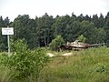
- Munster-Nord military training area

Muno lake, headwaters of the Örtze

Control tower shooting range 3
Hard target near the shooting range 4
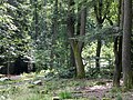
Oak and beech forest near shooting range 4

Armored shooting range 5, movable target on rails

Path to the shooting range 7


Breloh gas station
In the first World War
In 1916 the so-called Breloh camp was initially set up by the gas pioneer regiment in the north of Munster . In January 1917 the Prussian War Ministry gave the order to build a gas ammunition plant. The “Gasplatz Breloh” with three plants for the manufacture of chemical warfare agents and the manufacture of the corresponding ammunition was built on an approximately 6,500 hectare site in the robbery forest (part of today's Munster-Nord military training area) . Production started as early as July of the same year, and by the end of the First World War in 1918, extensive systems had been built and most of them were in operation.
Works of the Breloh gas field
(in the first World War)
| plant | size | was produced |
|---|---|---|
| Klopperwerk I | 560 m² | Green cross : phosgene , chloropicrin (Klop) and Pstoff (Per) |
| Klopperwerk II | 560 m² | Green cross: phosgene, chloropicrin (Klop) and Pstoff (Per) |
| Lostwerk I | 2,400 m² | Yellow Cross : Sulfur Mustard , Lewisite and Dick |
| Lostwerk II | 660 m² | Yellow Cross: Sulfur Mustard, Lewisite and Dick |
| Clarkwerk | > 2,500 m² |
Blue cross : Clark I Clark II (chlorine-arsenic warfare agents) The plant was not completed until the end of the war in 1918 |
In addition, the following infrastructure systems existed:
- power plant
- several barracks for a total of around 4,500 people
- around 100 km of tracks on the works railway
- a shooting range (up to 4,000 m) for experimental purposes
- several test sites and buildings
- several booty ammunition depots
- a research institute was also planned at Gut Westerhorn.
More than 6,000 people (75 officers, 677 NCOs and 5,775 other personnel) produced around a quarter of the total warfare ammunition for the German army in these facilities . The working conditions were catastrophic by today's standards. Professional protective clothing did not exist. The dangerous substances were handled carelessly. In addition to the production and storage of the company's own weapons, weapons ammunition was also filled here. In addition, booty ammunition was also stored in Munster, so u. a. about 20,000 chlorine gas bottles of Russian origin and smoke pots. Extensive tests with warfare agents and ammunition were carried out on shooting ranges and test areas.
Between the world wars

After the end of the war in 1918, around 48,000 tons of warfare ammunition, several thousand tons of prey ammunition filled with warfare agents and 40 tank wagons of unfilled warfare agents were stored on the gas field . These stocks should be dumped in the North and Baltic Seas .
During the preparations, there was a tragic accident on October 24, 1919. A train loaded with warfare agents and munitions exploded. With the exception of the Clark plant and the power plant buildings, almost the entire system was destroyed, a total of 48 buildings of the Green and Yellow Cross plants. 1,000 tons of war gas, around a million gas grenades, a million detonators and cartridges, 230,000 mines, 40 tank cars with war gas exploded. The warfare agent grenades were hurled through the area for kilometers, poison clouds threatened the surrounding villages, some of which had to be evacuated. Many houses in the area were badly damaged. In addition to the direct victims of the explosion, there were many other deaths in the months that followed.
The site was to be cleared by 1925. Around 1,000 workers superficially searched the landscape within 3 km of the explosion center. Search devices were not yet available at that time. A considerable amount of live ordnance was left behind. In 1921 the Hamburg company Stoltzenberg took over the work that had previously been carried out by the companies König and Evaporator AG. Stoltzenberg built a munitions incineration plant and a plant for converting chlorine gas and hydrogen . The latter exploded when it was put into operation in April 1922. Despite everything, the clearance work was completed in 1925 and the remaining facilities were blown up on the orders of the victorious powers.
In 1935 the Wehrmacht put Breloh back into operation as a “warfare agent test and gun training area”. An overall division of 15 percent warfare and 85 percent explosive ammunition was planned . Mustard gas ( mustard ) and chloroacetophenone were intended as fillings . The approximately 6,500 hectares of the former gas field had already gone to the Reichswehr Ministry at the beginning of 1934 and were expanded to around 10,200 hectares through acquisitions and expropriations. The entire property, most of which was built between 1935 and 1938, was named the Munster-Nord Army Research Center, often referred to as the Robbery Chamber Army Research Center . The main purpose of the facilities was the testing of chemical warfare agents, whereas the development took place in Berlin (Heeresgasschutzlaboratorium Zitadelle Spandau ). The weapons testing office 9 of the Heereswaffenamt and the Heeresgasschutzlabor moved from Berlin to Munster at the beginning of March 1945 due to the bombing and continued to work there until the end of the Second World War .
In World War II
Extensive tests were carried out with a wide variety of projectiles of various calibres and with mines , projectiles , bombs (up to 500 kg) and spray devices. The substances arsine oil , hydrocyanic acid , mustard gas ( mustard ), tabun , sarin , cyanogen chloride , chloroacetophenone , adamsite , aeroform , Excelsior (10-chloro-9,10-dihydroacridarsine) ( see list of chemical warfare agents ) and many others were tested here.
Warfare ammunition was filled in the so-called “fog filling station”. There was a tank system for around 3,000 tons of warfare agents. In this fog filling point there were extensive underground systems, some of which were connected with corridors.
During a spray demonstration by the Luftwaffe, a Do-217E-3 crashed on September 8, 1944, killing all occupants.
Most of the facilities were camouflaged as "simple" bunkers or as houses in the style typical of the country. An extensive rail network connected the individual parts of the site with one another. There was also a connection to the Reichsbahn line Wilhelmshaven-Berlin ( Kaiserbahn ).
After the Second World War
After the site was occupied by British troops in 1945, almost all chemical plants were destroyed and extensive warfare agents were destroyed in the years that followed. The remaining dangerous legacies are still among the largest legacy armaments in the Federal Republic. Since April 1956, intensive work has been carried out to remove the contaminated sites. Today it is primarily the company for the disposal of chemical warfare agents and old armaments mbH (GEKA) . which is located in the Defense Science Institute for Protective Technologies - NBC Protection . Since 2019, after groundwater contamination has been determined, the Dethlinger pond has been opened and cleared in the following years.
Munster camp
In 1891 Munster was still a small village in the Lüneburg Heath with 470 inhabitants. In 1905 it had grown to 1,225 inhabitants. On the existing railway line from Bremen via Soltau and Munster to Uelzen (Kaiserbahn Berlin-Wilhelmshaven), a troop camp was set up about 1.5 kilometers from the center of Munster. The camp was first occupied in June 1893 by the Oldenburg 91st Infantry Regiment under the command of the then Lieutenant Colonel and later Field Marshal and President Paul von Hindenburg .
At the turn of the 20th century there were u. a. Units for the fight against the Boxer Rebellion in China and units for the German colonies in Africa . During the First World War , the camp was also used for around 21,000 prisoners of war .
- Belgian and French prisoners in the Munster camp

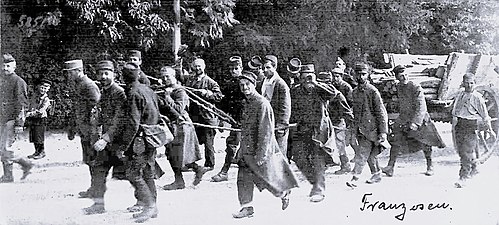


After the site was occupied by British troops, the British occupying forces set up the largest release camp for prisoner-of-war soldiers in the extensive military properties of the Wehrmacht in 1945. About 1.7 million prisoners of war are said to have been taken in Munster and Breloh and dispatched to their homeland. The Breloh refugee camp was established in the Hornheide camp. The various barrack camps, named by the British with the letters of the alphabet (example M-Lager), were in some cases only demolished in the 1960s after Munster no longer wanted to be a "Munster camp".
In 1956 Munster became the location for important military installations of the Bundeswehr, which was newly created in 1955 . Almost at the same time, the military training area command , the site administration , the armored troop school (today the armored troops training center ), the armored training brigade 9 with the armored infantry school, the armored infantry battalion and the armored infantry teaching battalion, the test center 53 (nowadays the military scientific institute for protection technologies ) and other NBC units and protection centers . Munster thus developed into the largest garrison of the Bundeswehr in united Germany.
The British stationing forces , which had maintained a garrison in Munster since the end of the war, finally gave it up in 1993 and left Munster. After the British withdrew from Munster, the open spaces were built on with residential and commercial buildings. The existing former barracks were restored and partially rebuilt. Today they mostly serve as commercial space. Stadtwerke Munster is now located in the former headquarters building, and the officers' mess has been converted into a hotel.
Publicity
Once a year, usually during the non-shooting period in July, parts of the site are released for “popular cycling”. Various signposted routes, which vary between around 20 and 110 km, are open for cyclists and inline skiers. The specified routes lead separately via Munster-Nord or Munster-Süd. In the former villages of Lopau and Sältingen, refreshment points and toilets will be set up.
Outside the closing times, on weekends without shooting, civilian traffic is allowed on Munster-Nord on individual, precisely named streets. Motor vehicle traffic is sometimes not allowed. On Munster-Süd, civil through traffic is permitted on various precisely designated roads during this period. Here, too, motor vehicle traffic is partly not permitted. You can tell whether the paths are open by the fact that the barriers are set up.
Two to three times a year there is a guided bus tour of the military training area. Registration through the tourist office of the city of Munster.
Commanders of the training area
- Colonel / Major General Eugen von Schkopp from March 25, 1893 to March 18, 1899
- Lieutenant Colonel / Colonel Erich von Falkenstein from February 1, 1928 to March 31, 1930
- Colonel / Major General Franz Becker from July 1, 1942 to May 30, 1944
The current commandant of the Munster Training Area Command is Lieutenant Colonel Jörg Heimann.
Web links
- History of the Munster military training area 1892–1928
- Munster military training area on streitkraeftebasis.de/
- Kurt Döring: Released prisoners of war in Munster camp and the “cold way” . In: Die Zeit , No. 30/1948
- Munster in old views
Individual evidence
- ^ Chronicle of the Sultingen School .
- ↑ Wolf pups in Munster Nord ( Memento from July 3, 2015 in the Internet Archive ).
- ↑ Chronology of the wolves in Lower Saxony .
- ↑ a b c d e f g Michael Grube: Warfare agent in Munster-Nord - Heeresversuchsstelle Robberkammer. In: geschichtsspuren.de. Retrieved August 16, 2018 .
- ^ City of Munster ( Memento from March 7, 2016 in the Internet Archive ).
- ↑ GEKA Munster
North area: Bergen | Munster North | Munster South | Nordhorn (L / BSchlPl) | Senne | Putlos
East area: Altengrabow | Altmark | Jägerbrück | Klietz | Upper Lusatia
South area: Baumholder | Grafenwohr | Hammelburg | Heuberg | Hohenfels | Wild spots