
Ehlbeck (Rehlingen)
|
Ehlbeck
Rehlingen municipality
Coordinates: 53 ° 5 ′ 21 ″ N , 10 ° 9 ′ 31 ″ E
|
||
|---|---|---|
| Height : | 68 m | |
| Residents : | 144 | |
| Incorporation : | March 1, 1974 | |
| Postal code : | 21385 | |
| Area code : | 04132 | |
Location of Ehlbeck in Lower Saxony |
||

Ehlbeck is one of five districts of the municipality of Rehlingen in the district of Lüneburg in Lower Saxony . Until the regional reform of Lower Saxony in 1974, Ehlbeck was independent and, with an area of 4319 hectares, the largest municipality in the Lüneburg district. Ehlbeck is a park-like place in the far west of the Lüneburg district with about 270 inhabitants. The place consists of four courtyards, two settler sites, a forest workers' settlement, the Finkenberg development area and individual houses from the period after the Second World War .
.png&filetimestamp=20120922093932&)
.png&filetimestamp=20120922093641&)
.png&filetimestamp=20120922092744&)
.png&filetimestamp=20120922094156&)
geography
Ehlbeck lies in the area of the terminal moraines of the last Ice Age. The gentle mountain ranges and the stream that flows through the Feldmark probably caused early settlement. The landscape was created in the Saale / Warthe stage 130,000 years ago with mountainous and occasionally steep terminal moraine lines south of the village and heights of up to 102 m. To the north, the gentle valley of the Ehlbeck stream was created with meadows and fertile arable areas. Here the glacier wall came to a standstill, whereby the meltwater flowed off to the south and left depleted sand behind, on which today's robbery chamber with a size of over 10,300 hectares stands and is mainly used as a military training area. It is listed as Sunder in old documents and has always been a ducal hunting ground, originally with an area of 1107 hectares. The purchase of farmland gave it its current size. From the Vogtey Amelinghausen it was reported in 1794: “The robbery is their royal Mayestät and Elector's Highness Wildlife and enclosure, in which nobody except the highest thought royal Mayestät neither hunt nor shoot, nor with the cut, nor with the mast drift is legitimate and this logging is about 22,000 paces in a circle ” . Hermann Löns and August Freudenthal also visited and described the robbery.
history
Ehlbeck is a very old settlement, as the more than 23 preserved barrows (1800–800 BC) and finds of flint daggers from the early Stone Age show. The place was originally divided into Osterehlbeck, Westerehlbeck, now called Rehrhof , and Süderehlbeck, which fell desolate early. In the Middle Ages, the two halves of the park-like town of Ehlbeck, the Rehrhof farmstead , known as Westerehlbeck , including the forestry department, and the several farms in Osterehlbeck, had to pay tribute to various feudal lords. While in Osterehlbeck the church in Amelinghausen , the parish church and the guild for the two Ehlbeck were entitled to tithe , those of Zahrenhusen shared the tithe of Westerehlbeck up to 1326 and that of Etzen up to 1330, and Lüne monastery both up until the first third of the 14th century Acquired halves. For Westerehlbeck and a court in Osterehlbeck, the landlords were the duke / magistrate and for two courts the pastor in Amelinghausen, for Süderehlbeck the count in Hoya. The tithe rights of all courts in Osterehlbeck were acquired in 1123 by the cathedral in Verden.
Under Napoleon, the two Ehlbeck were added to the Département d 'Aller of the Kingdom of Westphalia for a few years from 1810 , while the neighboring town of Amelinghausen became part of the French Empire. The border ran along the fields of the farms. When creating the border one orientates oneself on the map of the Electorate of Hanover from 1776. As a place Oster-Ehlbeck and Wester-Ehlbeck or Rehrhof belonged to the Commune Wulfsode des Cantons Ebstorf in the District Uelzen . Shortly before the end of the rule of the Kingdom of Hanover , Ehlbeck came temporarily to the Office of Salzhausen in 1852 , then again to the Office of Lüne in 1859 and, with the Prussian administrative reform of 1885, finally to the district of Lüneburg. For centuries, the Vogttey Amelinghausen comprised 39 towns from Luhmühlen to Poitzen vor Müden in the south. The bailiff had his seat on the manor in Amelinghausen, which was eligible for the state assembly, with at times three subordinates. The important manor had only around 2.5 hectares of land (very unusual).
As the chronicler Johann Heinrich Büttner writes, the Lüneburg patrician family of Eylebek (or Elebek), which died out in the 16th century, comes from Ehlbeck. The von Eylebeke already owned shares in the salt works in Lüneburg towards the end of the 13th century, where Sifridus de Eylebeke was councilor in 1295. Until their final extinction around 1600 in Lüneburg, the urban and Ehlbeck family branches probably inherited one another several times. The family then returned to the village in 1803 through inheritance and the purchase of another farm.
In 1866, the place in the Raubkammer wooded area suddenly appeared in the newspapers. On Maundy Thursday, March 29, district forester Müller from the Rehrhof chief forestry and forester Werner from Wulfsode (today's Uelzen district ) had a meeting with their foremen deep in the forest district. On the way home, the foresters found four poachers . The two were already in the process of getting their personal details from the quickly disarmed, when one of the poachers, the servant Hüners from Hützel, managed to get hold of a rifle in a flash and hit the forester. Müller was fatally hit. Werner was able to shoot and describe a fleeing poacher, so that the arrests were made quickly. Forester Werner suffered such severe injuries that he passed away on Good Friday night. With great sympathy from the population, the two foresters were laid to rest on the first day of Easter in the Amelinghausen cemetery. The jury court in Celle sentenced the shooter Hüners to 20 years chain sentence of the first degree. On July 1, the sentence began in the Lüneburg chain prison, which Hüners did not survive. The grave slab reminding of the two foresters has meanwhile been moved to the grounds of the Amelinghausen Church of St. Hippolit.
The thatched-roof stairwell in Osterehlbeck, the core building of which was built in 1746 and merged with a second soon after 1828, is considered the oldest preserved building in Ehlbeck . The construction date and the names of the builders (Hinnerich Christoffer and Anna Maria Westermann) can be found in the door beam on the ground floor of the building, which was newly thatched in 2012. The bakery from 1777 in Osterehlbeck and the scarcely younger wool store in Rehrhof, which was built between 1751 and 1800, should also be mentioned. Brisk building activity began on the farms before 1900 and shortly afterwards. Most of today's farm buildings were built due to the intensification of agriculture, especially mineral fertilization based on the knowledge of Justus von Liebig. The centuries-old, purely organic agriculture with extremely low grain yields of 3 to 5 dt / ha, which had led to the complete destruction of soil fertility, now came to an end.
On March 1, 1974, Ehlbeck was incorporated into the municipality of Rehlingen.

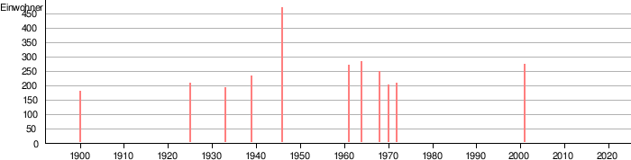
Population development
- 1900: 175 inhabitants
- 1925: 203 inhabitants
- 1933: 188 inhabitants
- 1939: 230 inhabitants
- 1946: 469 inhabitants
- 1961: 267 inhabitants
- 1964: 281 inhabitants
- 1968: 247 inhabitants
- 1970: 197 inhabitants
- 1972: 204 inhabitants
- 2001: 271 inhabitants
First mention
The place Oster-Ehlbeck was first mentioned in 1123 due to the purchase of the tithe of the farms in Oster-Ehlbeck by the cathedral in Verden. The place was originally divided into Wester-, Oster- and Süder-Ehlbeck. The total area is 4319 ha, by far the largest area in the region. Today's four farms had over 1000 hectares per farm for centuries. Wester-Ehlbeck was first listed as a table good for Verden Cathedral in 1252. Süder-Ehlbeck is attested in 1319 as the property of the Count of Hoya, probably fell into desolation early on and then does not appear in any records.
The courtyards
The three farms that still exist today in Oster-Ehlbeck and one farm in Wester-Ehlbeck / Rehrhof, as well as the small Buwhoff (farm), which was a forestry from 1764, are mentioned by name almost completely from 1430. The Buwhoff was probably a Kothe that branched off from a full courtyard in the 10th century. Originally there were significantly more farms, which were probably wiped out during the first plague in 1350 or in 1396 by the knight Statius von Mandelsloh, who devastated ducal areas on behalf of the city of Lüneburg. In the tax deed of January 21, 1562, two more desert farms in Oster-Ehlbeck and two in Wester-Ehlbeck are documented. Recently, a forest farm with a size of around 300 hectares has been created as the 5th farm through acquisitions. A specialty is the farming family called Ehlbeck in the village of Ehlbeck. They have been represented in the village as a court family with short interruptions from the beginning of written records to this day. In 1284 and 1295, Albert and Sifridus de Elebeke were two councilors of the Hanseatic city of Lüneburg . It can be assumed that it is an earlier noble family for which the place was named.
Coupling and expropriation of areas of the four courtyards
The first significant enlargement of the Sunder / Robbery Chamber took place in the course of the coupling of the meanness (division of the common areas of the four farms) from 1854 according to the Hanoverian agrarian reform laws of 1802 and 1832. The 470 fields and meadows were rounded up on 14 parcels and the The farms were finally assigned as property in 1835. A transfer of 306 hectares of farmland took place in 1854 and 1864 over 2158 hectares and another 461 hectares in 1935 only from the village of Oster-Ehlbeck. The removal of 2619 hectares in 1854 and 1864 without compensation has not yet been clarified. After all, it was 61% of the total area of the courtyards. The chief forester Quensel from Rehrhof, who belonged to the "flying column of the Hanoverian Forest Taxation Commission" , operated these removals. He was later dismissed without notice and in dishonor, denying all claims, and died in the poor house in Dresden . All farms around the robbery were expropriated in 1935 a total of 4805 hectares. This severely weakened the farms' livelihoods. Large areas of this are now used as shooting ranges for tanks .
Landlords of two farms
In 1368, two farms were bought by the Amelinghausen Church, whereby it remained the landlord until it was replaced in 1835, and the Duke in Celle for the other two farms. Handicrafts and tensioning services were never performed by the courts. The tithe from Oster-Ehlbeck went to the Amelinghausen Church and the St. Marien Guild in Ehlbeck and from Wester-Ehlbeck, later also called Rehrhof, to the Lüne Monastery.

Arable structure of the farms
The very precise linking map from 1828 allows the indirect conclusion that there were possibly up to ten farms in Oster-Ehlbeck due to special parcels in the village, the location of 470 long pieces of land and the network of paths. Some indirect features suggest that the site was founded before AD 800.
The arable soils, which are good for the region and which in recent times have encouraged the cultivation of wheat and sugar beet, therefore allowed a higher settlement density in earlier epochs than today. As a result, in addition to rye, the farms also delivered barley as tithe, which was also an indication of fertile arable soils in the 1681 inventory, which reached up to 50 points in the 1935 imperial soil estimate. Arable land per yard was between 60 and 150 hectares in size, and today's forest areas of 150 to 600 hectares per yard, which until the 19th century were, apart from a few oak and beech islands, heather areas. This favorable arable location was primarily the livelihood of the four farms for centuries, plus cattle husbandry with an average of 30 animals (1681) per farm and snuck husbandry on the heather, which could not be fully used at any time due to the oversize of the meanness. The largest herd of the Rehrhof farm with 420 dams was at times the largest in the Winsen district . The dairy farming with around 30 dairy cows and up to 40 heifers per farm in the most recent times, which was looked after by Melkern, all farms stopped in the 1960s due to high wage costs. Pure arable farms remained. On the other hand, beekeeping was rare in earlier centuries, despite the large heather areas.
Afforestation of the heath around Ehlbeck
The reforestation of the huge heather areas began cautiously in the state forest from 1784 by the Rehrhof forestry and on the rural areas from 1854. The large heather areas and the forests that are now developing on them encouraged game stock, especially that of the red deer. It was therefore inevitable that poaching also increased and escalated in 1866.

Historical finds
From the Bronze Age, a ring of 26 barrows is known around the site, as well as finds from the Stone Age and resting places for hunters who have not yet settled down. Of importance is the find of a woman's grave in a tumulus with numerous Bronze Age jewelery items along with very rare gold thread and a Lüneburg wheel needle, an urn cemetery from the pre-Roman Iron Age with 208 burials, a 40 cm high Roman bucket from the time of Christ's birth and a warrior from the Saxon period, which was buried on horseback.

Robber baron Moritz von Zahrenhusen
There is the legend of the robber baron Moritz von Zahrenhusen, who founded a new knight's seat in the neighboring village of Bockum and was shot by a Lüneburg merchant in 1590 near the village of Ehlbeck. The Zahrenhusenstein, located in the restricted area of the Munster Nord military training area, is a reminder of Moritz von Zahrenhusen, who became a robber baron in the legend . Here Moritz von Zahrenhusen is said to have been shot and buried with a silver button during an attack on a traveling merchant. The Low German local writer August Freudenthal reports in his Heidefahrten (1892–1906) that a skeleton was found at this point in the 19th century.
However, more recent research calls this into question, since around 1590 there have been no robber barons for over 200 years and Moritz von Zahrenhusen, as the former castle captain of the city of Lüneburg in Bleckede, has a great reputation among merchants and also with the duke in Celle to promote trade across the Elbe would have. The dishonorable behavior is more likely to be blamed on the merchant.
St. Mary's Guild from 1384

The guild St. Marien in Ehlbeck was a specialty . The guild certificate from 1384 with reference to 1319 shows in the statutes that it served mutual help in emergencies, not for the defense of the place. She was entitled to tithe and other dues every two years, alternating with the Church, and was therefore wealthy. It existed until 1803. The foundation could be before 1319, as the monastery was founded in the immediate vicinity in Steinbeck in 1243, was also called St. Marien and the foundation was therefore possibly suggested by its monks.
Settlers and new buildings
In addition to six settler sites, more than 30 family houses have recently been built in the village, five of them in 1935 for the poison gas plant in Brehloh. The four farms, the forestry department and the nearby military training area offered and still offer jobs.
Culture and infrastructure
The school in Ehlbeck was built in 1790 and closed in 1972. Before that, the children were taught by the sexton in Amelinghausen and in a previous school in Etzen. There was a road customs station with a bar on today's B209 in Wester-Ehlbeck / Rehrhof. Another inn called Constantinople existed from around 1850 until its demolition in 1961 on the B209. For a long time it was also a transformer station for wagons. There was also a post office in Ehlbeck.
Crafts and businesses as well as shops were probably never located in the village. The SV Ehlbeck has existed as a sports club since 1966, and has established itself as a public center in sports and culture, which is easy to integrate. The number of members in the sports club often clearly exceeds that of the town. In the old school is the children's play group founded in 1972. A small swimming pool has existed since 1964 and offers free bathing in summer.
Web links
- Website about the Zahrenhusen (Tzarenhusen) legend
- Monument panorama, LEADER + project of the “Central Lüneburg Heath Cultural Landscape” region with the participation of the Amelinghausen community
- Monument panorama - Wollspeicher
Individual evidence
- ↑ Search for geographical names. Federal Agency for Cartography and Geodesy, 2017, accessed on March 25, 2017 .
- ↑ In detail: Matthias Blazek: From the Landdrostey to the district government - The history of the district government of Hanover as reflected in the administrative reforms. Stuttgart 2004, ISBN 3-89821-357-9 .
- ↑ HSTA Hann. 74 Tom I. No. 28
- ↑ Hermann Löns , Heidebilder 1920.
- ↑ August Freudenthal: Heath rides. Missionary Action Hermannsburg
- ↑ Law Bulletin of the Kingdom of Westphalia / Bulletin des lois du royaume de Westphalie (1812), p. 471. Cf. Matthias Blazek: The Electorate of Hanover and the years of foreign rule 1803-1813. ibidem, Stuttgart 2007, ISBN 978-3-89821-777-4 .
- ^ Jürgen Peter Ravens: From Bardengau to the district of Lüneburg. 2nd Edition. Nordland-Druck, Lüneburg 1985, ISBN 3-922639-00-3 .
- ^ Johann Heinrich Büttner: Genealogy or family and genealogical registers of the noblest Lüneburg noble patrician families. Luneburg 1704.
- ^ Staircase storage facility Rehlingen Ehlbeck Hof Böttcher. ( Memento from July 10, 2012 in the web archive archive.today )
- ↑ a b c Federal Statistical Office (ed.): Historical municipality directory for the Federal Republic of Germany. Name, border and key number changes in municipalities, counties and administrative districts from May 27, 1970 to December 31, 1982 . W. Kohlhammer, Stuttgart / Mainz 1983, ISBN 3-17-003263-1 , p. 234 .
- ^ A b c Michael Rademacher: German administrative history from the unification of the empire in 1871 to the reunification in 1990. City and district of Lüneburg. (Online material for the dissertation, Osnabrück 2006).
- ↑ HSTA Hann. 74, Gepardi III cit. Spangenberg p.61.
- ↑ City Archives Lüneburg AB74a, Dr. Grieser II, pp. 8 + 66
- ↑ Source: Recesse: Private archive Hof Schlumbohm
- ↑ Source: HASTA Hann. Dr Grieser 1450-97, BS VIII, Lün1.
- ↑ Archive for Land Development, LGN, Hann./Limmer u. GLL
- ↑ Ernst Rüter: Winsen Office's stock book from 1681.
- ↑ Spindler, Georg: A contribution to the history of the forest office robbery chamber, 1996, diploma work.
- ↑ Dr. Laux, H. Gummel: Nachrichtenblatt f. Lower Saxony. P. 66, Finds at Hof Böttcher.
- ↑ Karl Henniger, Johann von Harten: Lower Saxony's Sagenborn - A collection of the most beautiful sagas and tales from northern Lower Saxony. 10th edition. A. Lax, Hildesheim 1987, ISBN 3-7848-8916-6 .
- ↑ August Freudenthal: Heath rides. unchangeable Reprint d. Ed. Heinsius, Bremen / Leipzig 1892–1906. Missionshandlung, Hermannsburg 1983, ISBN 3-87546-037-5 .
- ↑ Source: Lutz Tetau: Moritz von Zahrenhusen. 2008, ISBN 978-3-00-026049-0 .
- ↑ Lüneburg City Archives, VB, KL, 228V. AND City Archives Lüneburg, UB, KI, 228v.
- ^ Lüneburg papers. Issue 23, 1977, Steinbeck Monastery.
- ↑ A place for children for four decades. from: landeszeitung.de , February 16, 2013, accessed December 25, 2016.
- ↑ Schlumbohm was there for 52 years. In: State newspaper for the Lüneburg Heath. November 12, 2016, p. 11.
