
District of Uelzen
| coat of arms | Germany map |
|---|---|

|

Coordinates: 52 ° 59 ' N , 10 ° 33' E |
| Basic data | |
| State : | Lower Saxony |
| Administrative headquarters : | Uelzen |
| Area : | 1,454.22 km 2 |
| Residents: | 92,389 (Dec 31, 2019) |
| Population density : | 64 inhabitants per km 2 |
| License plate : | UE |
| Circle key : | 03 3 60 |
| NUTS : | DE93A |
| Circle structure: | 27 municipalities |
| Address of the district administration: |
Veerßer Strasse 53 29525 Uelzen |
| Website : | |
| District Administrator : | Heiko Blume ( CDU ) |
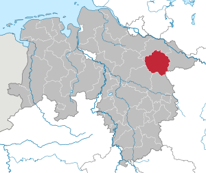
| Location of the Hanseatic City of Uelzen in Lower Saxony | |
  |
|
The district of Uelzen is a district in northeast Lower Saxony .
geography
location
The district is part of the climatically subatlantic main unit of the Lüneburg Heath in the northwestern German lowlands . The central landscape area is the Ice Age "Uelzener-Bevens Basin", which is framed by various moraine ridges. In the east there is, for example, the "Osthannoversche terminal moraine" (Göhrde- Drawehn -Höhenzug), to the west is the terminal moraine of the "Hohen Heide", which extends to the Harburg mountains south of Hamburg.
Neighboring areas
The district borders clockwise to the north, starting with the districts of Lüneburg and Lüchow-Dannenberg (both in Lower Saxony), the Altmark district of Salzwedel (in Saxony-Anhalt ) and the districts of Gifhorn , Celle and Heidekreis (all in Lower Saxony).
history
The district of Uelzen was formed on April 1, 1885 as part of the formation of districts in the province of Hanover from the old Hanoverian offices of Medingen and Oldenstadt and the independent city of Uelzen. The district administration was located in Oldenstadt until 1959 , which was an independent municipality and one of the smallest district seats in Germany until it was incorporated into neighboring Uelzen in 1972.
A number of small communities were incorporated into larger neighboring communities in 1928/29. As part of the regional reform in Lower Saxony on July 1, 1972, numerous municipalities merged and several boundary changes in the district took place. The municipalities of Meussießen and Reddien left the district and were incorporated into the municipalities of Clenze and Zernien in the Lüchow-Dannenberg district. The community Lopau also left the district and came to the city of Munster in the district of Soltau . The two communities Kakau and Varbitz from the Lüchow-Dannenberg district were incorporated into the Soltendieck community in the Uelzen district. The communities Grünhagen , Hohenbostel , Niendorf and Wulfstorf came from the district of Lüneburg to the community of Bienenbüttel in the district of Uelzen.
On November 1, 2011, the Wrestedt joint community with the municipalities of Stadensen , Wieren and Wrestedt dissolved and formed the new Wrestedt community, which together with the Bodenteich joint community formed the new Aue joint community . Also on November 1, 2011, the joint municipalities of Bevensen and Altes Amt Ebstorf merged to form the new joint municipality of Bevensen-Ebstorf .
- Impressions from the Uelzen district

Fountain in the spa gardens of Bad Bevensen
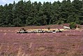
Klein Bünstorfer Heide

Oldenstädter See

University location Suderburg

Kaisergarten mill in Suhlendorf


_IMG_5029.jpg)


Population development
| year | Residents | source |
|---|---|---|
| 1890 | 44,833 | |
| 1900 | 47,576 | |
| 1910 | 52,216 | |
| 1925 | 56,998 | |
| 1939 | 61,382 | |
| 1950 | 117,614 | |
| 1960 | 95,400 | |
| 1970 | 95,900 | |
| 1980 | 95,600 | |
| 1990 | 93,490 | |
| 2000 | 97.285 | |
| 2010 | 94.020 |
Denomination statistics
In 2011, 63.6% of the population were Protestant , 6.6% Roman Catholic and 29.9% were non-denominational , belonged to another religious community or did not provide any information. The number of Protestants has fallen since then. Currently (as of December 31, 2019), according to church statistics, there are 51,885 Protestant members in the district, which is a good 56% of the district's population.
politics
District council
The district council is composed as follows:
| Parties and constituencies | Percent 2016 |
Seats 2016 |
Percent 2011 |
Seats 2011 |
Percent 2006 |
Seats 2006 |
|
|---|---|---|---|---|---|---|---|
| CDU | Christian Democratic Union of Germany | 36.0 | 15th | 39.7 | 17th | 44.4 | 19th |
| SPD | Social Democratic Party of Germany | 27.1 | 11 | 30.8 | 13 | 34.8 | 14th |
| Green | Alliance 90 / The Greens | 13.6 | 6th | 15.4 | 6th | 7.4 | 3 |
| UWG | Independent voter community | 8.9 | 4th | 7.7 | 3 | 6.3 | 3 |
| AfD | Alternative for Germany | 7.7 | 3 | ||||
| FDP | Free Democratic Party | 3.5 | 2 | 3.0 | 1 | 4.5 | 2 |
| WG NO A39 | Voting community NO A39 motorway | 1.0 | - | 1.7 | 1 | 2.6 | 1 |
| RRP | Retirees' party | 1.47 | 1 | ||||
| Others | 0.7 | 0 | 0.0 | 0 | 0.1 | 0 | |
| total | 100 | 42 | 100 | 42 | 100 | 43 | |
| Turnout in percent | 56.4 | 57.0 | 62.6 | ||||
last local election on September 11, 2016
District administrators

- Konrad von Massow , 1885
- Walter von Tzschoppe , 1885–1897
- Gustav Albrecht , 1897–1929
- Siegfried von Campe , 1929–1937
- Gustav Berlin , 1937–1943
- Magnus von Klinkowström , 1943–1944
- Carl Düvel , 1944-1945
- Wilhelm Harder, 1945–1946
- Heinrich Becker, 1946–1947
- Jürgen Frucht, 1947–1951
- Hermann Busse, 1951
- Heinrich Becker, 1951–1952
- Hermann Busse, 1952–1953
- Willi Scharnhop , 1953–1968
- Erich Schulze, 1968–1986
- Gerhard Schulze , 1986-2004
- Theodor Elster , 2004–2011
- Heiko Blume , since 2011
Senior district directors from 1945
- Wilhelm Harder, 1945–1946
- Friedrich von Rappard, 1946–1952
- Reinhart Berger , senior district director 1952–1975
- Rolf Sander, provisional 1975–1977
- Dietrich Hoppenstedt , 1977-1979
- Gerhard Geerdts, 1979–1986
- Rolf Sander, acting 1986
- Theodor Elster, 1986-2004 (abolition of the senior district director)
coat of arms
The model for the coat of arms of the district of Uelzen was evidently the coat of arms of the neighboring district of Lüneburg . The description is as follows: In a silver shield, sprinkled with red hearts, a soaring lion in blue. The red head of the shield is covered with three silver paw crosses with straight arms.
The three crosses adorn the coat of arms of the district of Uelzen in memory of the work of the three old monasteries Ebstorf, Medingen and Oldenstadt. The hearts were again integrated into the coat of arms based on the Danish royal coat of arms as a result of the marriage of Duke Wilhelm of Lüneburg to Princess Helena of Denmark .
Economy and Infrastructure

In the Future Atlas 2016 , the district of Uelzen was ranked 301 out of 402 districts, municipal associations and urban districts in Germany, making it one of the regions with a “balanced risk-opportunity mix” for the future.
The Uelzen district is one of the most intensively farmed districts in Lower Saxony. This structure is favored by loamy soils with a high rating on the invert of the Uelzen-Bevens basin. At the same time, low-yield locations on moraine or drift sand are artificially irrigated to a particularly high degree. In addition to cereals and sugar beets, potatoes are mainly grown. Fruit growing is also practiced locally on a large scale. The Nordzucker AG sugar factory - the largest and most modern in Germany - and the United Saatzucht Ebstorf (VSE), from which some well-known potato varieties come from, are of supraregional importance . There is also the Uelzena dairy and a subsidiary of Nestlé Schöller. There are hardly any larger industrial companies.
The district of Uelzen is part of the Lüneburg Landscape Association .
Tourism is mainly concentrated in Bad Bevensen and the surrounding area, including clinics. Bad Bodenteich has only been a spa for a few years. In Suderburg there is a faculty of the Ostfalia University of Applied Sciences .
traffic
Street
The important federal highway 4 ("Harz-Heide-Straße") runs through the district from north to south. Since the end of 2002 it has completely passed the district town and still crosses a few smaller towns in the northern district. There are controversial plans to extend the federal highway 39 from Wolfsburg to Lüneburg , which runs almost parallel to the east of the federal highway and is to be connected to the planned extension of the federal highway 14 Magdeburg - Schwerin at Uelzen . The first construction phase is to connect Uelzen with Lüneburg and thus the federal motorway 39 to Hamburg from 2020 . The federal road 71 runs from west ( Soltau ) to east and also through the city of Uelzen .
railroad
The city of Uelzen is a historical junction of the main line Hamburg- Hanover and the Bremen-Stendal-Berlin line, known as the American line , from which a connection to Braunschweig branches off in Wieren . The Uelzen-Dannenberg (West) railway line has been closed.
The access points Bienenbüttel, Bad Bevensen, Uelzen and Suderburg are on the Hamburg – Hanover route, on the American line Ebstorf, Uelzen, Stederdorf, Wieren and Soltendieck, and on the railway to Braunschweig the Bad Bodenteich train station.
Regional traffic on the Uelzen – Hamburg and Hamburg – Bremen routes has been operated by the metronom Eisenbahngesellschaft since December 2003 , and since December 2005 it has also been running from Göttingen via Hanover to Uelzen. Since the former depot in the area of the train station was closed and the areas including the buildings were sold, a new depot was created for the transport company in the north of the city of Uelzen.
With the 2017/18 timetable change, the local rail transport in the Uelzen district is to be integrated into the Hamburg transport association .
Inland shipping
The largest river in the district, the Ilmenau , is not navigable here, but the Elbe Lateral Canal connects the important shipping routes Elbe in the north and the Mittelland Canal in the south. The city of Uelzen has a port with a rail connection .
Archaeological monuments

The face of the district is determined by the Uelzen basin framed by wooded mountain ranges. The Ilmenau valley runs through the district from south to north. The favorable natural conditions as well as the fertile soils offered good prerequisites for human settlement from an early age.
This is reflected in the more than 6000 localized sites. Thus, the district one of the fund's richest regions of Lower Saxony represents From 1984 to 1986 inventoried a working group of the Institute of Cultural Heritage in the field through 4600 above ground visible archaeological objects. Megalithic tombs, grave mounds , stone boxes , militia and castles but also Altäcker ways tracks. The numerous urn cemeteries and settlement areas of different time periods could not be checked . Due to their condition and their historical significance, almost 2,700 objects have been included in the register of cultural monuments.
The extraordinary wealth of finds aroused the interest of archaeologists at an early stage. The mapping of the landmarks in the area by Chamberlain Georg Otto Carl von Estorff in the first half of the 19th century and the excavations by Gustav Schwantes shortly before the turn of the century are particularly noteworthy . Schwante's merit is the creation of an outline of the pre-Roman Iron Age, the stages of which he named after the sites in the district. The Jastorf cemetery even gave its name to the Jastorf culture , a cultural group of the older pre-Roman Iron Age in eastern Lower Saxony, Holstein and Mecklenburg .
The oldest finds in the district come from the Paleolithic and Middle Stone Age (approx. 600,000 to 4500 BC). In the Museum Schloss Holdenstedt , the so-called shield core of Medingen can be viewed, a tool that was made between the last and penultimate Ice Age and is therefore 80,000 or even 100,000 years old. Lehmke's hand ax, which is also exhibited in Holdenstedt, is probably of a similar age.
Among the visible monuments in the city and district area, the grave structures make up the largest share, they are also the most striking legacies of prehistoric man. Burial mounds and large stone graves once shaped the landscape. In 1846 Carl von Estorff published the impressive number of 6,000 burial mounds, of which 2609 have survived. The losses at large stone graves are far greater. Of the 219 recorded by Estorff, 29 were still preserved in 1986, only 12 of them were in good condition, including:
- Hünenbett near Kahlstorf
- Royal tombs near Haaßel
- Melzingen sacrificial stone
- Stone box in the Uelzen city forest
Restored burial mounds are:
- Grave field in the Addenstorfer Heide (Bad Bevensen)
- at the city harbor in Uelzen
- in the urban area of Bad Bevensen
Communities
(Population figures as of December 31, 2019)


- Bienenbuttel (6711)
- Uelzen , district town , independent municipality (33,536)
Joint municipalities with their member municipalities
* Seat of the joint municipality administration
|
|
Former parishes
The following list contains all former municipalities that ever belonged to the Uelzen district.
Incorporation dates: 1) 1928/29, 2) July 1, 1957, 3) January 1, 1971, 4) November 1, 2011
All other incorporations took place on July 1, 1972.
Until its dissolution in the 1920s, the district of Uelzen also had the estate districts of Göddenstedt, Lintzel, Niebeck, Oechtringen, Oitzfelde, Reisenmoor , Sankt Omer, Scharnhop, Solchstorf and Süsing, as well as the forest districts of Böhe, Breitenhees , Lohn, Maschbruch and Wiebeck.
Protected areas

In addition to landscape protection areas and natural monuments, there are 22 designated nature reserves in the district (as of February 2017).
See also:
- List of nature reserves in the Uelzen district
- List of landscape protection areas in the Uelzen district
- List of natural monuments in the Uelzen district
- List of protected landscape components in the Uelzen district
License Plate
On July 1, 1956, the district was assigned the UE distinguishing mark when the license plates that are still valid today were introduced . It is still issued today.
literature
- Reinhart Berger (ed.): The district of Uelzen: history, landscape, economy . Stalling, Oldenburg 1973.
- Ulrich Bohm, Sigrid Vierck : 125 years of the Uelzen district . Uelzen 2010. ISBN 978-3-9813718-0-2 .
- Theodor Elster: The district of Uelzen . Verlag Kommunikation und Wirtschaft, Oldenburg 1991. ISBN 3-88363-096-9 .
- Gunther Schendel: A Prussian district administrator as a donor. The Gustav Albrechts foundations in Oldenstadt . In: Heimatkalender 2011 for the city and district of Uelzen , Uelzen 2010, pp. 77–84.
- Martin Schwind : The Uelzen district: regional and statistical district description as a basis for administration and regional development . Dorn, Bremen-Horn 1949.
- Hans E. Seidat: Green heart of the heather: the district of Uelzen . Self-published by the district of Uelzen, Uelzen 1981.
- Klaus-Dieter Vogt: Uelzen: its city-surroundings relationships in a historical-geographical perspective . Geographer. Inst. D. Univ. Göttingen 1968 (also Diss. Techn. Univ. Hannover)
- Christian Wiegand: Out and about in the Uelzen district: history and character of a cultural landscape in the Lüneburg Heath . Husum, Husum 2002. ISBN 3-89876-072-3 .
- Hans-Cord Sarnighausen: Local lawyers from 1677 to 1866 in Oldenstadt near Uelzen. In: GENEALOGY. Verlag Degener & Co., Issue 2/2009, pp. 508-524.
- Eckehard Niemann: National Socialism in the Uelzen District - Volume 1 1925-1933; Volume 2 1933-1939; Volume 3 1939-1945 , self-published by E. Niemann, 29553 Varendorf 2014, 2016 and 2017.
Web links
- Literature from and about the Uelzen district in the catalog of the German National Library
Individual evidence
- ↑ State Office for Statistics Lower Saxony, LSN-Online regional database, Table 12411: Update of the population, as of December 31, 2019 ( help ).
- ^ District regulation for the province of Hanover (1884)
- ↑ Law on the reorganization of the communities in the Lüchow area, June 27, 1972
- ↑ Law on the reorganization of the communities in the Uelzen area and in the area of the city of Münster, May 16, 1972
- ↑ Law on the amalgamation of the municipalities of Bodenteich and Wrestedt and on the new formation of the municipality of Wrestedt, April 28, 2011
- ^ Ordinance on the merger of the integrated communities Bevensen and Altes Amt Ebstorf. 16 December 2010
- ↑ a b c d e f g h Michael Rademacher: German administrative history from the unification of the empire in 1871 to the reunification in 1990. ueltzen.html. (Online material for the dissertation, Osnabrück 2006).
- ↑ Statistical Yearbook for the Federal Republic of Germany 1972
- ↑ Statistical Yearbook for the Federal Republic of Germany 1981
- ↑ a b c Lower Saxony regional database
- ↑ District of Uelzen Religion , 2011 census
- ↑ Newsletter Church Uelzen Statistics 2019 , accessed on July 6, 2020
- ↑ Final result of local elections 2016
- ↑ Brohm, Ulrich; Vierck, Sigrid, 125 years of the Uelzen district (publications of the Uelzen district archive 6), ed. v. Uelzen district, district archive), Uelzen 2010, p. 141.
- ↑ Brohm; Vierck, as above, p. 155.
- ↑ Future Atlas 2016. (No longer available online.) Archived from the original on October 2, 2017 ; accessed on March 23, 2018 . Info: The archive link was inserted automatically and has not yet been checked. Please check the original and archive link according to the instructions and then remove this notice.
- ↑ From December 2017: Rail traffic in the district of Uelzen comes to the HVV in Nahverkehr Aktuell , accessed on October 24, 2016
- ↑ State Office for Statistics Lower Saxony, LSN-Online regional database, Table 12411: Update of the population, as of December 31, 2019 ( help ).
- ^ Municipal directory 1910: District of Uelzen
- ↑ territorial.de: Uelzen district
Counties : Ammerland | Aurich | Celle | Cloppenburg | Cuxhaven | Diepholz | Emsland | Friesland | Gifhorn | Goslar | Göttingen | County of Bentheim | Hameln-Pyrmont | Harburg | Heidekreis | Helmstedt | Hildesheim | Holzminden | Empty | Lüchow-Dannenberg | Lüneburg | Nienburg / Weser | Northeim | Oldenburg | Osnabrück | Osterholz | Peine | Rotenburg (Wümme) | Schaumburg | Stade | Uelzen | Vechta | Verden | Wesermarsch | Wittmund | Wolfenbüttel
Region : Hanover
Independent cities : Braunschweig | Delmenhorst | Emden | Oldenburg (Oldb) | Osnabrück | Salzgitter | Wilhelmshaven | Wolfsburg