Gollern
|
Gollern
City of Bad Bevensen
Coordinates: 53 ° 4 ′ 46 ″ N , 10 ° 38 ′ 35 ″ E
|
||
|---|---|---|
| Height : | 49 m | |
| Incorporation : | July 1, 1972 | |
| Postal code : | 29549 | |
| Area code : | 05821 | |
|
Location of Gollern in Lower Saxony |
||
|
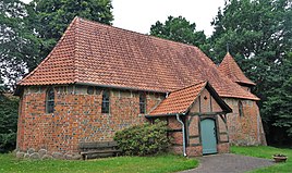
Castle chapel in Gollern
|
||
Gollern is a district of the town of Bad Bevensen in the Lower Saxony district of Uelzen .
Geography and transport links
Gollern is east of the core town of Bad Bevensen . The state road L 253 runs north and the L 252 south. The Elbe Lateral Canal flows to the west .
Attractions
Architectural monuments
In the list of architectural monuments in Bad Bevensen , two architectural monuments are listed for Gollern :
- The castle chapel on the southwestern outskirts of Gollern is a brick building in the Romanesque and Gothic styles. The chapel looks back on at least 800 years of history and originally served as a fortified chapel.
- Farm sheep stall (Gollern No. 2)
See also
Web links
Commons : Gollern - collection of images, videos and audio files


