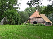
Lopau
Lopau is a largely closed village in the Lüneburg Heath . It is located on the Munster -Nord military training area on its extreme northern edge. It used to belong to the district of Uelzen , today it belongs to the Lower Saxony city of Munster in the district of Heidekreis . The access from Wulfsode is free. The access via the town of Ehlbeck is not paved. The entrance to Munster is largely closed to the public. The area may only be entered when the barriers to the military training area are open.
The heather river Lopau rises here with two arms of the spring, to the northwest and east of the former village dammed into ponds and lakes .
history
The village was first mentioned in 1293; at that time it consisted of three farms. In 1895 the industrialist Richard Toepffer acquired the "Aevermannschen Hof" , a Heidehof in need of renovation , in Lopau. The old farmhouse had to be demolished because it was in disrepair. He converted a barn into his home and turned the 3,000- acre area into a representative country estate. The property was also used to demonstrate new agricultural and forestry machinery. In particular, he wanted to demonstrate the efficiency of steam plows on the impoverished soils in preparation for reforestation and arable farming. Around 1900 the village had 123 inhabitants and a school. In 1922 the estate was sold to the state. In 1942 the Gauleiter Telschow received the farm and 40 hectares of land from the state as a gift. He built a bunker on the site, parts of which are still preserved today. In 1970 there were still 62 people living in Lopau. The Toepffers estate itself was demolished in 1978 by the Bundeswehr . The " Haus Schilling ", named after a displaced person who lived here after the Second World War , was the home of the supervisor family during Toepffer's time, is now a home for the Munster Forest Youth . The former home of the forest workers (Alte Forstwartei ) now serves as the operating and residential building of the Federal Forests division of the Federal Agency for Real Estate . At one of the source ponds of the Lopau is the "house catch bag" , which was given to the city of Munster for civil use. It is intended to serve youth care purposes in particular and is mainly used by the Munster sports fishing club and the forest youth.
1 July 1972 changed Lopau from Uelzen district in the district of Soltau . In addition, the community lost its independence and was incorporated into the city of Munster.
When shooting range 7 at Munster Nord military training area was built in the early 1980s , Lopau fell into the security area and its residents were relocated .
The Bundeswehr's original plan to build the shooting range near the edge of the village and to run an armored ring road through the valley met with resistance from the regional population and led to the establishment of the action group Rettet das Lopautal . The commissioning of the shooting range was subsequently delayed by over ten years. The designation of the valley as a nature reserve failed due to the veto of the Bundeswehr. On shooting range 7, the tanks are only allowed to drive on paved roads so that the water in the source area of the Lopau is not polluted.
Personalities
- Richard Toepffer , industrialist (1840-1919). The ruin of the "pottery tower" is reminiscent of Toepffer and the time when the large heather and moor areas were cultivated (today's spelling differs from the name!). The pottery towerlies north of the old village and is located on the upper reaches of the Lopau on the right steep bank. The top floor of the original pottery tower was demolished during the renovation, while the ground floor was made accessible to hikers.
- The heath poet Hermann Löns mentions Lopau in his book Haidbilder , chapter Das Könekenmeer, and also the steam plows mentioned above. He writes:
" If you walk along Hützeler Weg from Lopau, which is back there in the Haide between Ülzen and Munster [...] Before the steam plow rummaged through the land here and prepared the ground for the loads [...] ] everything was bare Schnuckenheide [...] "
Web links
Individual evidence
- ↑ a b Federal Statistical Office (ed.): Historical municipality register for the Federal Republic of Germany. Name, border and key number changes in municipalities, counties and administrative districts from May 27, 1970 to December 31, 1982 . W. Kohlhammer GmbH, Stuttgart and Mainz 1983, ISBN 3-17-003263-1 , p. 235 .
- ↑ Land surveying and geographic base information Lower Saxony, topographic map 1: 25 000 (TK25), sheet 2927, Wriedel 2002, ISBN 978-3-89435-170-0 .
- ↑ Pines
Coordinates: 53 ° 3 ' N , 10 ° 12' E


