
Hösseringen
|
Hösseringen
municipality Suderburg
Coordinates: 52 ° 51 ′ 24 " N , 10 ° 24 ′ 54" E
|
||
|---|---|---|
| Height : | 82 m above sea level NN | |
| Area : | 36.68 km² | |
| Residents : | 571 (2017) | |
| Population density : | 16 inhabitants / km² | |
| Incorporation : | July 1, 1972 | |
| Postal code : | 29556 | |
| Area code : | 05826 | |
Location of Hösseringen in Lower Saxony |
||
 The Landtagplatz in Hösseringen
|
||

Hösseringen ( Low German Hössen ) is a district of the municipality Suderburg in the combined municipality Suderburg and is located in the southwestern district of Uelzen , Lower Saxony . The place was first mentioned in 1247 and incorporated into Suderburg on July 1, 1972.
geography
Hösseringen is located between Hamburg and Hanover in the Lüneburg Heath . The place is characterized by agriculture, the landscape of the Hohe Heide and the surrounding extensive forest areas, which extend in the southwest to Eschede .
The place is criss-crossed by terminal moraines from the penultimate Ice Age and is accordingly located on several hills or small chains of hills. Approx. The Hardau rises 2 km south-east of the town center and flows into the Gerdau after its further course through the Hardautal between Holxen and Holdenstedt . After their retreat, the glaciers left behind deposits of marl and diatomite, all of which were exploited.
Culture and sights
- The place is known nationwide due to the approximately ten hectare area of the museum village Hösseringen . The museum village is also the starting point of the Schooten Forest History Trail, which leads through the forest area of the same name and describes the changes in agriculture and forestry in the Lüneburg Heath at ten stations.
- In the immediate vicinity of the museum village is the Landtag Square, which was the meeting place of the Landtag of the Principality of Lüneburg in the early modern period from 1532 to 1652 . The Lüneburg knighthood erected a memorial stone here in 1902. In the 1930s the square was redesigned to its present form. Since then it has consisted of numerous boulders from the places and with the place names of the then Uelzen district.
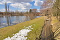
- Hösseringen is the starting point for the 26-kilometer water adventure trail that stretches to Uelzen . Stations of this path are the water treading facility at the village pond and the artificially created Hardausee , near which there is also a camping and barbecue area.
- Hösseringen observation tower, a 37.5 m high clinker brick tower between Hösseringen and Räber, built in 2003 as a carrier for mobile radio transmission antennas, with an observation platform at a height of around 32 m .
- Located on the Lower Saxony Mill Road, there is also a water mill close to the town center , but it is no longer in operation.
- Since opening in 1957, the former Waldhotel and Café Bötzelberg has helped shape the Hardautal holiday region in Hösseringen. In 2003 it was converted into a beauty farm.

Main building of the Brümmerhof in the museum village

Hardausee

Landtagplatz

Restaurant "Haus am Landtagplatz"

Landtagplatz
Mill pond

Water treading system


_IMG_5633.jpg)
_IMG_5639.jpg)
_IMG_5735.jpg)

Associations and groups
The sports club TSV Hösseringen, the singing club Frohsinn e. V. and the shooting club "Schootenring". There is also a marching band and the Hösseringen support group, as well as the volunteer fire brigade.
The “Plattsnackers” meet once a month, mostly in the house on Landtagplatz. The Schootenfest is celebrated every year in midsummer. An Easter bonfire is also held every year near the observation tower.
At the beginning of the year there is a debate between political representatives and the citizens, the so-called peasant bill .
The local sponsor company is the AufklLehrKp 90 in Munster . The sponsorship has existed for 30 years now and is still actively pursued.
literature
- Tilman Grottian : History of the Suderburg community. Festschrift for the 1000th anniversary in 2004. Edition Anderweit, Suderburg-Hösseringen 2004, ISBN 3-931824-33-0 .
- Rolf Hillmer : History of the Suderburg community. Bahnsen, Böddenstedt, Graulingen, Hamerstorf, Hösseringen, Holxen, Oldendorf I, Räber (= writings on Uelzen local history. No. 6, ISSN 0941-1666 ). C. Becker, Uelzen 1986.
- Ernst Andreas Friedrich : The Landtagplatz of Hösseringen. In: Ernst Andreas Friedrich: If stones could talk. From the history of Lower Saxony. Volume 3. Landbuch-Verlag, Hannover 1995, ISBN 3-7842-0515-1 , p. 156 ff.
Individual evidence
- ↑ http://suderburg.de/verwaltung/einwohnerstatistik.htm
- ^ Federal Statistical Office (ed.): Historical municipality directory for the Federal Republic of Germany. Name, border and key number changes in municipalities, counties and administrative districts from May 27, 1970 to December 31, 1982 . W. Kohlhammer, Stuttgart / Mainz 1983, ISBN 3-17-003263-1 , p. 239 .
- ↑ Lookout tower on the website of the Suderburger Land eV tourism association
Web links
Eimke with the districts Dreilingen , Eimke , Ellerndorf and Wichtenbek
Gerdau with the districts Bargfeld , Barnsen , Bohlsen , Gerdau , Groß Süstedt and Holthusen II
Suderburg with the districts Bahnsen , Böddenstedt , Hamerstorf , Hösseringen , Holxen , Räber and Suderburg