
Beehive
| coat of arms | Germany map | |
|---|---|---|

|
Coordinates: 53 ° 9 ′ N , 10 ° 29 ′ E |
|
| Basic data | ||
| State : | Lower Saxony | |
| County : | Uelzen | |
| Height : | 30 m above sea level NHN | |
| Area : | 99.03 km 2 | |
| Residents: | 6711 (Dec. 31, 2019) | |
| Population density : | 68 inhabitants per km 2 | |
| Postal code : | 29553 | |
| Area code : | 05823 | |
| License plate : | UE | |
| Community key : | 03 3 60 004 | |
| LOCODE : | DE 3BJ | |
| Community structure: | 14 districts | |
| Address of the municipal administration: |
Marktplatz 1 29553 Bienenbüttel |
|
| Website : | ||
| Mayor : | Merlin Franke ( CDU ) | |
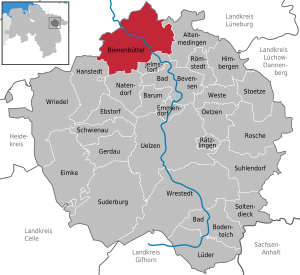
| Location of the municipality of Bienenbüttel in the Uelzen district | ||
  |
||

Bienenbüttel is a unified community on the eastern edge of the Lüneburg Heath in the north of the Uelzen district , Lower Saxony , on the border with the Lüneburg district between Hamburg and Hanover .

geography
Community structure
The municipality of Bienenbüttel consists of the core town of Bienenbüttel and the following districts (since 1972):
The administrative headquarters are located in the Bienenbüttel district .
Flowing waters
By far the largest Heide river, the Ilmenau , as well as the Bienenbütteler Mühlenbach, the Eitzener Bach, the Varendorfer Bach, the Krumbach, the Forellenbach (designated nature reserve ), the Riester Bach and the Vierenbach (designated nature reserve ) flow through the community . The water quality is predominantly class II (slightly polluted), with the exception of a section of the Mühlenbach and the entire Varendorfer Bach, which was divided into class III (heavily polluted).
history
As a settlement area, the area of the unitary community has been based on archaeological finds since around 8000 BC. Occupied. Several barrows near Eitzen I, Hohenbostel and between Hohnstorf and Wichmannsburg are evidence of settlement in the Bronze Age . About 1.2 kilometers south of Edendorf there is a large stone grave ( tumulus ). In 1890 a grave with around 1000 urns from the Lombards' time was found near Rieste .
Bienenbüttel itself looks back on a documented 1000 year history.
The Thirty Years' War also raged in Rieste. The Swedish soldiers looted and devastated the place ("Rystede") in 1634/35. “They ate chickens” is an entry for the entire village. The farms of Hans Rademacher and Hans Meyer were hardest hit. The entry in the register behind these two farm names reads: "Have all of their sheep been taken from the Swedish and burned down miserably."
As early as the 19th century, places were amalgamated into larger units. On May 6, 1884, Grünewald was incorporated into the district of Beverbeck, Bardenhagen to Eitzen I and Wichmannsdorf to Bornsen. The interests of a municipality were regulated by an appointed mayor. In 1966 the communities of Bargdorf, Beverbeck, Edendorf, Eitzen I, Hohnstorf and Wichmannsburg merged with Bienenbüttel to form the joint community of Bienenbüttel. Steddorf joined in 1967.
Incorporations
On July 1, 1972, the communities Bargdorf, Beverbeck, Bornsen, Edendorf, Eitzen I, Grünhagen (until then in the district of Lüneburg ), Hohenbostel (also), Hohnstorf, Niendorf, Rieste, Steddorf, Varendorf, Wichmannsburg and Wulfstorf were incorporated. Grünhagen, Hohenbostel, Niendorf and Wulfstorf belonged to the Lüneburg district.
Place name
Earlier place names of Bienenbüttel were Biangibudiburg in 1004 and Binebutle in 1288. The second part of the place name Büttel comes from butli and means 'settlement, residence'. The first part is an old short name Bio or Biho . It belongs to the tribe "bih" or "bi", in Old Saxon "bina" and means bee .
politics
Municipal council

The council of the municipality of Bienenbüttel consists of the mayor and another 18 members.
| CDU | SPD | GREEN | KA | total | |
| 2016 | 7th | 3 | 3 | 5 | 19 seats |
Status: Local election on September 11, 2016 ; KA: Local political alternative
mayor
- from November 1, 2006 to March 31, 2013 Heinz-Günter Waltje (CDU), elected with 52.4% of the votes cast.
- since April 1, 2013 Merlin Franke (CDU), elected on January 20, 2013 with 42.2% of the votes cast. The term of office is eight years.
Mayor
No local councils are formed. After each municipal election, an honorary mayor is appointed for each district.
coat of arms
A single-towered silver castle with a golden scale on top of the spire is depicted on a green background. There is a golden fish below the castle. The castle refers to the Biangibudiburg from the Billunger times and the scales symbolize the former Bienenbüttel bailiwick as a sign of jurisdiction. In Bienenbüttel there was a ford into the Wendland , which provided the occasion for the establishment of the place and was therefore made clear by the fish on the coat of arms.
Economy and Infrastructure

Due to the transport links, Bienenbüttel is an attractive place to live for commuters. 1,942 out-commuters are compared to 516 in-commuters according to statistics from the Federal Employment Agency on June 30, 2013. Of the 6,533 inhabitants, 3,310 (50.7%) are female (as of December 31, 2013). Bienenbüttel is the seat of Almased Wellness GmbH .
traffic
The unified community is on the Hanover – Hamburg railway line (stopping point of the metronom ). Bienenbüttel is also on Bundesstraße 4 . In addition, the Elbe Lateral Canal runs through the community in the east (Wulfstorf jetty).
Public facilities
- There are four kindergartens and a crèche for pre-school education
- Primary school children attend the school in Bienenbüttel.
- A forest pool and several sports facilities can be used.
- There is a community library on the market square.
- Burials take place in the cemeteries in Bienenbüttel, Niendorf, Bornsen and Wichmannsburg.
- The fire protection and general help is through the volunteer fire department ensured the community.
Denominations
_Cropped.jpg)
- Evangelical Lutheran parish of Bienenbüttel
- Evangelical Lutheran parish Wichmannsburg
Sons and daughters of the church
- Jürgen Wilhelm Harms (1885–1956), born in Bargdorf, zoologist and university professor
- Wilhelm Engelhard (or Engelhardt) (1813–1902), portrait painter
- Wilhelm Heinrich Krüger (1857–1947), biologist and researcher, discoverer of the algae genus Prototheca and the free-living soil bacteria Azotobacter .
- Johanne Marie Hermine Ritz (née Schlie; * October 20, 1859; † 1939), poet, lived in Hohnstorf from 1886.
- Georg Heinrich Wilhelm Blumenbach
- Karl Kayser (1843–1910), 1871 to 1877 pastor of St. George's Church in Wichmannsburg
literature
- Eberhard Behnke, Heinrich Porth: The families and residents of the parish Wichmannsburg. Local family book 1663–1920, study of population history, ownership succession of farms and address books 1907–1978. To the places Bargdorf, Edendorf with Hönkenmühle, Hohnstorf, Solchstorf and Wichmannsburg (= sources and representations on the history of the city and district of Uelzen. Vol. 9). Museum and local history association of the Uelzen district, Uelzen 2009, ISBN 3-929864-16-9 .
- Hans-Cord Sarnighausen: On the 700-year history of the church in Bienenbüttel. In: Yearbook of the Society for Church History in Lower Saxony. Vol. 104, 2006, ISSN 0072-4238 , pp. 309-318; Home calendar for the city and district of Uelzen. 2007, ISSN 0937-3748 , pp. 41-45.
- The unified community of Bienenbüttel and its districts. An overview of the past and present on the occasion of the 1000th anniversary. Published by the Bienenbüttels History Working Group on behalf of the Samtgemeinde, Books on Demand, Norderstedt 2004, 2nd edition, ISBN 978-3-7357-2791-6 ; limited preview in Google Book search.
Web links
Individual evidence
- ↑ State Office for Statistics Lower Saxony, LSN-Online regional database, Table 12411: Update of the population, as of December 31, 2019 ( help ).
- ↑ On regional and administrative reform, cf. Matthias Blazek : From Landdrostey to district government. The history of the Hanover district government as reflected in the administrative reforms. ibidem-Verlag, Stuttgart 2004, ISBN 3-89821-357-9 .
- ↑ Regulation text on the nature reserve "Schierbruch and Forellenbachtal".
- ↑ Regulation text on the “Vierenbach” nature reserve.
- ^ Matthias Blazek: The fire extinguishing system in the area of the former principality of Lüneburg from the beginnings to 1900. Self-published, Adelheidsdorf 2006, ISBN 3-00-019837-7 , p. 94.
- ^ Federal Statistical Office (ed.): Historical municipality directory for the Federal Republic of Germany. Name, border and key number changes in municipalities, counties and administrative districts from May 27, 1970 to December 31, 1982 . W. Kohlhammer, Stuttgart / Mainz 1983, ISBN 3-17-003263-1 , p. 237 .
- ^ Jürgen Udolph (research): The "place name researcher". In: website NDR 1 Lower Saxony . Archived from the original on August 17, 2014 ; accessed on August 3, 2019 .
- ^ A b Lars Lohmann: Nothing new in the north . In: Bienenbüttel informed . Bienenbüttel September 21, 2016, p. 29-30 .
- ↑ Municipal Council - Welcome to the website of the Bienenbüttel municipality! Retrieved May 19, 2020 .
- ↑ Official announcement of the municipal election officer from January 20, 2013.
- ↑ Walter Koptik: Community chronicle Bienenbüttel . Ed .: Municipality of Bienenbüttel. 1967, p. 2 .
- ↑ welt.de .
- ↑ Hermine Ritz, b. Close on books.google.de
- ^ Literature by and about Hermine Ritz in the catalog of the German National Library
- ^ Gerhard Wollenweber: Our Church St. Georg . In: Ev.-luth. St. Georgskirchengemeinde (ed.): St. Georgs-Bote . Wichmannsburg 2012, p. 15 .
Altenmedingen | Bad Bevensen | Bad Bodenteich | Barum | Beehive | Ebstorf | Eimke | Emmendorf | Gerdau | Hanstedt | Himberg Mountains | Jelmstorf | Lüder | Natendorf | Oetzen | Rätzlingen | Römstedt | Roshe | Schwienau | Soltendieck | Stoetze | Suderburg | Suhlendorf | Uelzen | Vest | Wrestedt | Wriedel