
Himberg Mountains
| coat of arms | Germany map | |
|---|---|---|

|
Coordinates: 53 ° 6 ' N , 10 ° 44' E |
|
| Basic data | ||
| State : | Lower Saxony | |
| County : | Uelzen | |
| Joint municipality : | Bevensen-Ebstorf | |
| Height : | 56 m above sea level NHN | |
| Area : | 39.48 km 2 | |
| Residents: | 1679 (Dec. 31, 2019) | |
| Population density : | 43 inhabitants per km 2 | |
| Postal code : | 29584 | |
| Area code : | 05828 | |
| License plate : | UE | |
| Community key : | 03 3 60 011 | |
| Community structure: | 10 districts | |
| Association administration address: | Lindenstrasse 12 29549 Bad Bevensen |
|
| Website : | ||
| Mayor : | Jürgen Hinrichs (community of voters) | |
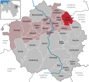
| Location of the municipality of Himbergen in the district of Uelzen | ||
  |
||

Himbergen is a municipality in the middle of the Lüneburg Heath in the district of Uelzen , Lower Saxony . The Himbergen community is part of the Bevensen-Ebstorf community .
geography
The municipality of Himbergen consists of the localities Almstorf, Brockhimbergen , Groß Thondorf , Himbergen, Hohenfier, Kettelstorf, Klein Thondorf, Kollendorf, Rohrstorf and Strothe.
history
Brockhimbergen, Rohrstorf and Kollendorf were first mentioned in a document in 1006. From 1966 to 1972 there was a joint municipality of Himbergen, which consisted of the municipalities of Almstorf, Brockhimbergen, Himbergen, Klein Thondorf, Kettelstorf, Kollendorf, Rohrstorf and Strothe.
On July 1, 1972, the municipalities of Almstorf, Brockhimbergen, Groß Thondorf, Kettelstorf, Klein Thondorf, Rohrstorf and Strothe as well as small areas of the municipality of Göhrde ( Lüchow-Dannenberg district ) were incorporated.
politics
Municipal council
The council of the municipality of Himbergen consists of eleven councilors.
| CDU | SPD | Green | WGS | total | |
| 2006 | 6th | 4th | 1 | 11 seats | |
| 2011 | 0 | 0 | 0 | 11 | 11 seats |
Last local election on September 11, 2011
mayor
Mayor is Jürgen Hinrichs (community of voters). The municipal administration is located at Bahnhofstrasse 1.
Culture and sights
-kirche.jpg)
- The focal point is the St. Bartholomew Church , built in the classical style from 1843.
- Himberger Markt, which has been celebrated every year since 1666 on the first Tuesday after September 1st.
- Local history collection in the former water tower - Pictures and objects from the 19th and early 20th centuries from the parishes of Himbergen and Göhrde are exhibited here.
- The three staircase storages from the 19th century were used to store crops and chests with linen and valuables.
literature
- Gunda Friesch and Heinrich Porth: The families and residents of the parish of Himbergen: Local family book 1670-18951758-1875 and study of the population history , with the places Almstorf, Boecke, Brockhimbergen, Glieneitz, Groß Malchau, Groß Thondorf, Hagen, Himbergen, Hohenzethen, Kettelstorf, Klein Thondorf, Kollendorf, Nievelitz, Reddien, Rohrstorf, Schlagte, Schlankau, Stoetze, Strohte, Testof, Törwe, Weste, Westersunderberg, Wolfshof and Zieritz. Uelzen: Museum and Heimatverein des Kreises Uelzen 2006, ISBN 3-929864-10-X (= sources and representations on the history of the city and district of Uelzen 6).
Web links
Individual evidence
- ↑ State Office for Statistics Lower Saxony, LSN-Online regional database, Table 12411: Update of the population, as of December 31, 2019 ( help ).
- ^ Federal Statistical Office (ed.): Historical municipality directory for the Federal Republic of Germany. Name, border and key number changes in municipalities, counties and administrative districts from May 27, 1970 to December 31, 1982 . W. Kohlhammer GmbH, Stuttgart / Mainz 1983, ISBN 3-17-003263-1 , p. 237 .
- ^ Result of local elections 2011
Altenmedingen | Bad Bevensen | Bad Bodenteich | Barum | Beehive | Ebstorf | Eimke | Emmendorf | Gerdau | Hanstedt | Himberg Mountains | Jelmstorf | Lüder | Natendorf | Oetzen | Rätzlingen | Römstedt | Roshe | Schwienau | Soltendieck | Stoetze | Suderburg | Suhlendorf | Uelzen | Vest | Wrestedt | Wriedel