Wichmannsburg
|
Wichmannsburg
Municipality Bienenbüttel
Coordinates: 53 ° 8 ′ 10 ″ N , 10 ° 30 ′ 54 ″ E
|
||
|---|---|---|
| Height : | 33 m | |
| Residents : | 433 (2014) | |
| Incorporation : | July 1, 1972 | |
| Postal code : | 29553 | |
| Area code : | 05823 | |
|
Location of Wichmannsburg in Lower Saxony |
||
Wichmannsburg is a part of the Bienenbüttel community in the Lower Saxony district of Uelzen .
history
The first human traces in Wichmannsburg are barrows from the Bronze Age on the northeastern edge of the town.
In the 10th century Wichmann I the Elder had a castle built on what is now the local area to protect Billung's property against the Wends . The current name of the place goes back to Wichmann I. Structural remains of the castle are no longer preserved. The castle was on a small island in the Ilmenau near today's Burgstrasse.
In 1966 the previously independent Wichmannsburg became part of the municipality of Bienenbüttel.
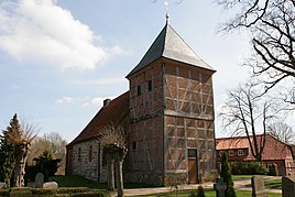
The historical center, which is still preserved today, concentrates on the area around St. George's Church . In the course of the 20th century, Wichmannsburg developed along today's Kreisstraße 1 into a row village. Towards the end of the 20th century, the place was expanded considerably with new development areas on the Sandberg.
Geography and transport links
Wichmannsburg is located southeast of the core town of Bienenbüttel on the district road K 1 and on the Ilmenau . The B 4 runs to the west . North, the 230 extends ha large nature reserve Four Bach .
Attractions
Architectural monuments
In the list of architectural monuments in Bienenbüttel , four architectural monuments are listed for Wichmannsburg :
- St. George's Church with churchyard and cenotaph (Billungstrasse)
- Rectory (Billungstrasse 33)
- Residential building (Billungstrasse 38)
- The Sandberg 1 house was built in the middle of the 19th century. The facade of the single - storey half-timbered house with a half- hip roof has seven axes. The entrance is in the middle.
tourism
The Way of St. James “Via Scandinavica” leads through Wichmannsburg .
Various bike tours run through the village, including the national Weser-Harz-Heide-Radfernweg and the Ilmenau-Radweg.
In Wichmannsburg, at kilometer 34.4 of the Heide River Ilmenau, there is a jetty with a rest area, toilet and tent facilities. The closest piers are 6 kilometers upstream in Bruchtorf and 2.5 kilometers downstream in Bienenbüttel.
Personalities
- Karl Kayser (1843–1910), 1871 to 1877 pastor of St. George's Church in Wichmannsburg
Web links
- Wichmannsburg on bienenbuettel.de
Individual evidence
- ↑ Stefan Waltje, Heike Schweer: district Edendorf . In: Working Group History of Bienenbüttel (Ed.): 1010 years of Bienenbüttel . BoD - Books on Demand, Norderstedt 2014, p. 92 .
- ↑ Wichmannsburg - Welcome to the website of the Bienenbüttel community! Retrieved May 4, 2020 .
- ↑ Karl Kayser: Chronicle of the Wichmannsburg parish in the Hanoverian office of Medingen . Meyer, Hannover 1878, p. 9-14 .
- ^ Hector Wilhelm Heinrich Mithoff: Fürstenthum Lüneburg . In: Art monuments and antiquities in Hanover . tape 4 . Helwing, Hannover 1877, p. 271 .
- ↑ Wichmannsburg - Welcome to the website of the Bienenbüttel community! Retrieved May 4, 2020 .
- ↑ Wichmannsburg - Welcome to the website of the Bienenbüttel community! Retrieved May 4, 2020 .
- ^ Martin Simon: Via Scandinavica . In: The journey is the goal . Conrad Stein, Welver 2015, ISBN 978-3-86686-477-1 , pp. 123-126 .
- ↑ Weser-Harz-Heide-Radfernweg. In: https://hann.muenden-erlebnisregion.de . Retrieved August 17, 2020 .
- ↑ Uelzen - Bad Bevensen - Bienenbüttel. In: ilmenauradweg.de. Retrieved August 17, 2020 .
- ↑ ... the Ilmenau. In: Canoe active. Retrieved August 17, 2020 .
- ↑ Boat rental on the Ilmenau. In: kanufertiglos.de. Retrieved August 17, 2020 .
- ^ Gerhard Wollenweber: Our Church St. Georg . In: Ev.-luth. St. Georgskirchengemeinde (ed.): St. Georgs-Bote . Wichmannsburg 2012, p. 15 .


