Lüneburg Landwehr
The Lüneburg Landwehr is a system of Landwehr ditches with which the medieval city of Lüneburg primarily enforced its stacking rights .
Purpose of the Landwehr
The salt town of Lüneburg had the stacking right since 1392. This meant that in a wide area around Lüneburg every traveling merchant had to first bring his goods to Lüneburg in order to "stack" them there, i.e. H. had to offer for sale before he was allowed to move them on. Of course, the merchants wanted to avoid this, and they left the main streets with their carts and tried to drive around the city on side roads. In order to prevent the merchants from bypassing Lüneburg, land weirs were built to the west and east of the city. The Lüneburg Landwehr thus played an important role in directing trade.
Structure and course
The Lüneburger Landwehr were densely planted, impassable earth walls that were separated by moats. If possible, natural watercourses were dammed and incorporated into the facilities. There were only a few easy-to-control passages, some of which were secured with watchtowers.
Old Landwehr
The old Landwehr was built between 1397 and 1406 about 4 kilometers west of the Lüneburg city gates. The Landwehr consisted of up to five earth walls, which were separated by moats up to two meters deep. Beginning on the Ilmenau near the Goseburg in Lüneburg, the Landwehr initially led south of Bardowick westward to the area of Vögelsen . Here it bent to the south and led west past Reppenstedt to the Hasenburger Bach. From then on it ran along the dammed water to the Rote Schleuse on the Ilmenau. Watchtowers were installed at the checkpoints south of Bardowick and near Reppenstedt, and another watchtower on the Hasenburger Bach, which is still preserved today, was built between 1450 and 1480.
Route descriptions created around 1700 prove that the Landwehr was passed at the checkpoint at the Hasenburger Bach from the road leading to Celle via Häcklingen , Melbeck and Ebstorf . Another road to Celle led via Embsen , Betzendorf and Wulfsode . The post to Ebstorf also made its way via the Hasenburg control post, and the freight car route to Braunschweig also ran here . A barrier forced the travelers to stop.
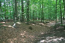
The earth walls and trenches of the Old Landwehr are well preserved to this day. The wooded section between Reppenstedt and Vögelsen offers a special impression of the structure and size of the facility. An unpaved forest path makes it possible to hike the entire route.
New Landwehr
About 70 years after the completion of the Old Landwehr , the Lüneburg Council decided to create another Landwehr. The so-called New Landwehr was built between 1479 and 1484 about 5 kilometers east of Lüneburg and consisted of a 2 meter high and 6 meter wide earth wall, which was accompanied on both sides by about 1.5 meter high ramparts. The Landwehr originally extended from Rullstorf in a southerly direction via Neu Wendhausen to the swampy terrain on the Dieksbach near Deutsch Evern . Watchtowers were built near Neu Wendhausen and east of Deutsch Evern am Dieksbach.
There was a great need for excavated soil to build the earth walls. The soil was of course not transported over long distances, but removed on site. When the earth walls were built near Rullstorf, the large Easter pond was created, which was then dammed up and incorporated into the Landwehr. However, the Easter pond silted up within 300 years and a forest developed in its place.
The earth walls of the Neue Landwehr are also well preserved over large stretches. Most of them run through forest areas and are densely overgrown in places.
Mapping
The Lüneburg Landwehr were mapped by Daniel Freese :
- 1580 Demolition of the Lüneburg Landwehr with the new borders of the Lüneburg jurisdiction. (Main State Archive Hanover, map department 31 k / 1pm)
- 1576 Demolition of the Lüneburg Landwehr with the claimed limits of Lüneburg jurisdiction. (Main State Archive Hanover, map department 31 k / 37pk; paper, pencil and pen drawing, watercolors, 41 x 30.5 cm, scale about 1: 65000)
Others
In the middle of the 14th century, the Hannoversche Landwehr was built as an advanced fortification system to protect the city of Hanover . The first, about 8 km long section was built around 1341 and also called the "Lüneburger Landwehr".
literature
- Martin Pries: The Lüneburg Landwehr . In: On cultural geography and industrial archeology in Northern Germany. Supply - Defense - Transport. Verlag Beier & Beran, 1999, ISBN 3-00-004059-5
- Martin Pries: The Lüneburger Landwehr from a cultural-geographic perspective in: Niedersächsisches Jahrbuch für Landesgeschichte 78, 2006, pp. 2–16 ( Online , 7.2 MB)
- Joost Assendorp: Die Landwehr der Stadt Lüneburg in: Reports on the preservation of monuments in Lower Saxony , 2/1982, pp. 45–48
Web links
Individual evidence
- ^ Erich Hessing : Monuments, people and history in the district of Lüneburg . Stern, 1981
- ↑ Wiebke Kirleis: Vegetation history and archaeobotanical studies on agriculture and the environment in the area of prehistoric settlements in Rullstorf, Lüneburg district . Dissertation at the Georg-August University in Göttingen, 2002


