
Melbeck
| coat of arms | Germany map | |
|---|---|---|

|
Coordinates: 53 ° 11 ' N , 10 ° 24' E |
|
| Basic data | ||
| State : | Lower Saxony | |
| County : | Luneburg | |
| Joint municipality : | Ilmenau | |
| Height : | 21 m above sea level NHN | |
| Area : | 16.17 km 2 | |
| Residents: | 3323 (Dec 31, 2019) | |
| Population density : | 206 inhabitants per km 2 | |
| Postal code : | 21406 | |
| Area code : | 04134 | |
| License plate : | LG | |
| Community key : | 03 3 55 024 | |
| LOCODE : | DE MLC | |
| Address of the municipal administration: |
Floetstrasse 4 21406 Melbeck, Germany |
|
| Website : | ||
| Mayor : | Klaus Huebner ( CDU ) | |
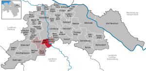
| Location of the community of Melbeck in the Lüneburg district | ||
  |
||

Melbeck is a municipality in the Ilmenau municipality in the Lüneburg district in Lower Saxony . It is the administrative seat of the Ilmenau community.
politics
The municipality of Melbeck belongs to the state electoral district 48 Elbe and to the federal electoral district 38 Lüchow-Dannenberg - Lüneburg .
Melbeck's municipal council has 15 members, including the mayor.
(Status: local election on September 11, 2016)
Streets
The busy federal highway 4 leads to the cities of Lüneburg and Uelzen . Around 19,100 cars and 1,500 trucks per working day reduce the quality of life in the neighboring quarters. There it is hoped that the federal motorway 39 will be built soon , which is to be built with the aim, among other things, of relieving the traffic through local roads.
In addition, Melbeck is directly connected to all other member communities by the district roads 7, 10 and 33.
Transportation
Between 1913 and 1977 the place was indirectly connected to public transport via the Melbeck-Embsen train station . The Melbeck-Bahnhof district is about 1.5 km from the town center. In 1928 a private bus line Lüneburg-Melbeck was set up, which in 1930 passed to the Kleinbahn and was extended via Kolkhagen to Barnstedt. After the war a railway bus line Lüneburg – Melbeck – Uelzen was added; later the Lüneburg – Barnstedt line was expanded to include a ring route via Embsen and Heinsen.
Melbeck is now located on the southern border of the Hamburg transport association , which connects Melbeck with the four lines (line 5600, line 5604, line 5606, line 5700). These offer connections to all neighboring communities as well as to the nearby Lüneburg with the Lüneburg ZOB terminus , including a transition to regional and long-distance traffic on the Hanover – Hamburg and Lübeck – Lüneburg lines, as well as to other bus routes. In addition, the KVG Stade operates another line several times a day (line 5605), which connects Melbeck with the municipality of Bienenbüttel and the local train station with regional traffic and offers the opportunity to switch to other bus lines.
The Lüneburg – Soltau line runs through the Melbeck-Bahnhof district , but only museum traffic runs here .
education
In Melbeck there is a kindergarten and a primary school (Ebstorfer Straße). There is also the private high school Lüneburg Heath (Schützenstrasse). A model of the solar system on a scale of 1: 1 billion, the GLH Planet Trail, runs through the place .
leisure
There are several sports clubs in Melbeck, including SV Ilmenau von 1923 e. V. with three natural grass pitches for soccer as well as a fitness center and a club house at the Melbeck site. Other sports are offered in the neighboring Deutsch-Evern. The rifle club Melbeck and the surrounding area from 1921 e. V. has two shooting ranges and an archery range. On the Ilmenau there is the campsite and the holiday village Melbeck with tent sites, caravan and mobile home sites as well as a canoe rental with a jetty. The Melbeck volunteer fire brigade has a fire station on the B 4.
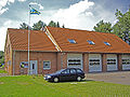
Volunteer firefighter

Haus am Osterberg (Protestant community center)

Artwork watermill

Watermill


Neighboring communities
|
Häcklingen / Rettmer 3.1 km / 4.5 km |
Lueneburg 4.4 km |
Deutsch Evern 1.3 km |
|
Embsen 0.0 km |
.svg)
|
|
|
Kolkhagen / Barnstedt 2.2 km / 5.0 km |
Bardenhagen / Eitzen I 4.2 km / 5.0 km |
Grünhagen / Bienenbüttel 2.4 km / 4.3 km |
Web links
Individual evidence
- ↑ State Office for Statistics Lower Saxony, LSN-Online regional database, Table 12411: Update of the population, as of December 31, 2019 ( help ).
- ↑ Landtag constituencies from the 16th electoral term. Constituency division for the election to the Lower Saxony state parliament. Annex to § 10 para. 1 NLWG, p. 4. ( PDF ( Memento of the original from July 25, 2011 in the Internet Archive ) Info: The archive link has been inserted automatically and has not yet been checked. Please check the original and archive link according to the instructions and remove then this note .; 87 kB)
- ↑ Description of the constituencies. Annex to Section 2, Paragraph 2 of the Federal Election Act. In: Eighteenth law amending the federal electoral law. Annex to Article 1. Bonn, March 18, 2008, p. 325. ( PDF ( Memento of the original from July 25, 2011 in the Internet Archive ) Info: The archive link has been inserted automatically and has not yet been checked. Please check the original and archive link according to the instructions and then remove this note .; 200 kB)
- ↑ Lower Saxony State Authority for Road Construction and Transport (client): Investigation of the route finding for a federal trunk road A 39 Wolfsburg – Lüneburg ( memento of the original from September 27, 2007 in the Internet Archive ) Info: The archive link was automatically inserted and not yet checked. Please check the original and archive link according to the instructions and then remove this notice. . February 2006, point 1.4.5
- ^ Matthias Bublitz: Lines in Lüneburg. A journey through 100 years of transport history: Local transport in the city and district. Norderstedt 2012, p. 41 ff.

Cities: Bleckede | Luneburg . Other communities: Adendorf | Amelinghausen | Neuhaus Office | Artlenburg | Bardowick | Barendorf | Barnstedt | Barum | Betzendorf | Boitze | Brietlingen | Dahlem | Dahlenburg | German Evern | Echem | Embsen | Handorf | Hittbergen | Hohnstorf (Elbe) | Kirchgellersen | Lüdersburg | Mechtersen | Melbeck | Nahrendorf | Networks | Oldendorf (Luhe) | Broken wheel | Rehlingen | Reinstorf | Reppenstedt | Rullstorf | Scharnebeck | Soderstorf | Südergellersen | Thomasburg | Tosterglope | Vastorf | Birds | Wendisch Evern | Westergellersen | Wittorf .