Ludersburg
| coat of arms | Germany map | |
|---|---|---|

|
Coordinates: 53 ° 19 ' N , 10 ° 34' E |
|
| Basic data | ||
| State : | Lower Saxony | |
| County : | Luneburg | |
| Joint municipality : | Scharnebeck | |
| Height : | 6 m above sea level NHN | |
| Area : | 18.87 km 2 | |
| Residents: | 642 (Dec. 31, 2019) | |
| Population density : | 34 inhabitants per km 2 | |
| Postal code : | 21379 | |
| Primaries : | 04139, 05850, 04136 | |
| License plate : | LG | |
| Community key : | 03 3 55 021 | |
| LOCODE : | DE LDS | |
| Community structure: | 5 districts | |
| Association administration address: | Marktplatz 1 21379 Scharnebeck |
|
| Website : | ||
| Mayor : | Klaus Bockelmann (FWGL) | |
| Location of the community Lüdersburg in the district of Lüneburg | ||
Lüdersburg is a municipality in the Samtgemeinde Scharnebeck in the district of Lüneburg in Lower Saxony .
geography
Expansion of the municipal area
The parish covers an area of 18.87 square kilometers.
Community structure
The districts of Ahrenschulter , Bockelkathen , Grevenhorn , Jürgenstorf and Neu-Jürgenstorf belong to the community .
history
Lüdersburg was first mentioned in a document in 1234. However, archaeological excavations indicate that around 800 human settlements were found here. The origin of the place name Lüdersburg probably comes from Lothar's castle.
Incorporations
Before 1974 there were two independent communities with Lüdersburg and Jürgenstorf. On March 1, 1974, the neighboring community Jürgenstorf was incorporated into the community Lüdersburg. The first mayor was Helmuth Schäfer.
politics
The community of Lüdersburg belongs to the state electoral district 48 Elbe and to the federal electoral district 38 Lüchow-Dannenberg - Lüneburg .
Mayor / City Council
Mayor of the community is Klaus Bockelmann (FWGL), deputy mayor is Frank Büntig (CDU), general representative is Sonja Strasser-Hildebrandt (SPD). Since the local election on September 11, 2016, the local council has been composed as follows.
coat of arms
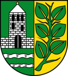
The municipality's coat of arms is divided vertically. On the non-heraldic left side there is a silver structure (the former manor) above two silver watercourses of the old Neetze and the Bruchwetter on green ground. The non-heraldic right side shows a six-leaved green linden branch on a golden background. The linden leaves represent the 6 districts of the municipality. The branches for the wide expanse.
fire Department
In the community of Lüdersburg there are two volunteer fire departments Lüdersburg and Jürgenstorf. Both fire brigades together have around 45 members. The municipality of Scharnebeck is responsible for fire protection .
Culture and sights
The village center is the 16th century church of Peter and Paul. The church tower was built by Werner von Spörcken in 1872 instead of a wooden tower.
The community is known for the palace complex, which was built as a mansion in 1776 and has been owned by the Barons of Spörcken since the 18th century . The castle is now operated as a hotel with a golf course, the Schloss Lüdersburg golf course. The entire center of Lüdersburg is a listed building. On aerial photos you can still see that Lüdersburg must have been a round village in the past.
Individual evidence
- ↑ State Office for Statistics Lower Saxony, LSN-Online regional database, Table 12411: Update of the population, as of December 31, 2019 ( help ).
- ^ Federal Statistical Office (ed.): Historical municipality directory for the Federal Republic of Germany. Name, border and key number changes in municipalities, counties and administrative districts from May 27, 1970 to December 31, 1982 . W. Kohlhammer GmbH, Stuttgart / Mainz 1983, ISBN 3-17-003263-1 , p. 234 .
Web links
- Website of the joint community
- Website of the community of Lüdersburg
- Entry by Stefan Eismann zu Lüdersburg in the scientific database " EBIDAT " of the European Castle Institute


