
Nahrendorf
| coat of arms | Germany map | |
|---|---|---|
 Help on coat of arms |
Coordinates: 53 ° 11 ′ N , 10 ° 49 ′ E |
|
| Basic data | ||
| State : | Lower Saxony | |
| County : | Luneburg | |
| Joint municipality : | Dahlenburg | |
| Height : | 72 m above sea level NHN | |
| Area : | 44.04 km 2 | |
| Residents: | 1239 (Dec. 31, 2019) | |
| Population density : | 28 inhabitants per km 2 | |
| Postal code : | 21369 | |
| Area code : | 05855 | |
| License plate : | LG | |
| Community key : | 03 3 55 025 | |
| LOCODE : | DE NHD | |
| Association administration address: | Am Markt 17 21368 Dahlenburg |
|
| Mayor : | Uwe Meyer | |
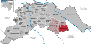
| Location of the community in Nahrendorf in the district of Lüneburg | ||
  |
||

.jpg)
Nahrendorf is a municipality in the district of Lüneburg in Lower Saxony .
geography
Geographical location
Nahrendorf is located in the Elbhöhen-Wendland nature park . The community is part of the Samtgemeinde Dahlenburg , which its administrative headquarters in the spots Dahlenburg has.
Community structure
Districts of the community are Breese , Eichdorf, Kovahl, Lüben, Moislingen, Mücklingen, Neestahl, Nieperfitz , Nüdlitz, Oldendorf an der Göhrde, Pommoissel , Röthen, Süschendorf and Tangsehl.
history
A forester in the forester's house Röthen, a locality of the municipality, was already on record in 1690. A well-known position holder was the forester Ferdinand Wallmann (1826-1921), formerly Gehegereiter in Hanover, to whom the position was transferred on October 1, 1868.
Incorporations
On March 1, 1974, the communities of Kovahl, Mücklingen, Oldendorf an der Göhrde and Pommoissel were incorporated.
politics
The community of Nahrendorf belongs to the state electoral district 48 Elbe and to the federal electoral district 38 Lüchow-Dannenberg - Lüneburg .
Mayor:
The honorary mayor Uwe Meyer was elected on September 9, 2001 .
Attractions
The St. Lamberti Church in the town center can already be found in documents from the St. Michaeliskloster in Lüneburg from 1271. At the end of the 18th century, the church had to be completely renewed after being damaged by various storms. At the beginning of the 1960s, the building was again extensively renovated. The facade style is unusually charismatic.
traffic
Road traffic
The federal road 216 Lüneburg - Dahlenburg - Dannenberg (Elbe) runs through the district of Oldendorf an der Göhrde about three kilometers south of the municipality's capital .
Rail transport
The Göhrde station of the Wendlandbahn , which runs from Lüneberg to Dannenberg, is located in the Nahrendorf district of Breese am Seißelberge . It is the last stop of the HVV tariff heading east. The name of the station refers to the state forest of Göhrde and once served as the Wilhelmine imperial railway station for the Prussian state hunts. Today the station has become a stopping point, but you can clearly see where the tracks once lay. The train station itself is not signposted and is rather difficult to find. In addition to the ongoing rail traffic, there has been a lively educational traffic: The Göhrde train station has been an educational institution for emancipatory children, youth and adult education since 1979.
sons and daughters of the town
- Wolfgang Bode (1887–1964), Member of the State Parliament (DP)
literature
- Nahrendorf. Ev. Church. In: Georg Dehio : Handbook of German Art Monuments . Bremen Lower Saxony. Deutscher Kunstverlag, Munich / Berlin 1992, ISBN 3-422-03022-0 , p. 963.
Individual evidence
- ↑ State Office for Statistics Lower Saxony, LSN-Online regional database, Table 12411: Update of the population, as of December 31, 2019 ( help ).
- ^ Journal of Forestry and Hunting, Volume 54, published by Julius Springer, Berlin 1922, p. 723.
- ^ Federal Statistical Office (ed.): Historical municipality directory for the Federal Republic of Germany. Name, border and key number changes in municipalities, counties and administrative districts from May 27, 1970 to December 31, 1982 . W. Kohlhammer GmbH, Stuttgart / Mainz 1983, ISBN 3-17-003263-1 , p. 233 .
- ↑ Landtag constituencies from the 16th electoral term. Constituency division for the election to the Lower Saxony state parliament. Annex to § 10 para. 1 NLWG, p. 4. ( PDF ( Memento of the original from July 25, 2011 in the Internet Archive ) Info: The archive link has been inserted automatically and has not yet been checked. Please check the original and archive link according to the instructions and remove then this note .; 87 kB)
- ↑ Description of the constituencies. Annex to Section 2, Paragraph 2 of the Federal Election Act. In: Eighteenth law amending the federal electoral law. Annex to Article 1. Bonn, March 18, 2008, p. 325. ( PDF ( Memento of the original from July 25, 2011 in the Internet Archive ) Info: The archive link has been inserted automatically and has not yet been checked. Please check the original and archive link according to the instructions and then remove this note .; 200 kB)
Web links

Cities: Bleckede | Luneburg . Other communities: Adendorf | Amelinghausen | Neuhaus Office | Artlenburg | Bardowick | Barendorf | Barnstedt | Barum | Betzendorf | Boitze | Brietlingen | Dahlem | Dahlenburg | German Evern | Echem | Embsen | Handorf | Hittbergen | Hohnstorf (Elbe) | Kirchgellersen | Lüdersburg | Mechtersen | Melbeck | Nahrendorf | Networks | Oldendorf (Luhe) | Broken wheel | Rehlingen | Reinstorf | Reppenstedt | Rullstorf | Scharnebeck | Soderstorf | Südergellersen | Thomasburg | Tosterglope | Vastorf | Birds | Wendisch Evern | Westergellersen | Wittorf .