
Südergellersen
| coat of arms | Germany map | |
|---|---|---|

|
Coordinates: 53 ° 13 ' N , 10 ° 18' E |
|
| Basic data | ||
| State : | Lower Saxony | |
| County : | Luneburg | |
| Joint municipality : | Gellersen | |
| Height : | 44 m above sea level NHN | |
| Area : | 18.47 km 2 | |
| Residents: | 1835 (Dec. 31, 2019) | |
| Population density : | 99 inhabitants per km 2 | |
| Postal code : | 21394 | |
| Area code : | 04135 | |
| License plate : | LG | |
| Community key : | 03 3 55 035 | |
| LOCODE : | DE UGS | |
| Address of the municipal administration: |
In the old village 5 21394 Südergellersen |
|
| Website : | ||
| Mayor : | Annette Kammeier ( CDU ) | |
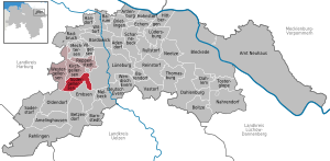
| Location of the community of Südergellersen in the district of Lüneburg | ||
  |
||

Südergellersen is a municipality in the district of Lüneburg in Lower Saxony and a member municipality in the joint municipality of Gellersen .
geography
Geographical location
Südergellersen lies between the nature reserves Lüneburg Heath and Elbufer-Drawehn. The municipality belongs to the Gellersen municipality , which has its administrative seat in the municipality of Reppenstedt .
Community structure

The community of Südergellersen consists of the villages of Südergellersen and Heiligenthal .
history
First mention
The community was first mentioned in a document in 1267.
prehistory
From the fourth millennium BC The remains of a stone grave date from the Neolithic Age , but today it is completely destroyed. A number of burial mounds from the Stone and Bronze Ages have also been preserved in the area around the village . The specimens on the sports field in the village are impressive. This group of burial mounds originally consisted of at least a dozen specimens. When the sports field was expanded, three of them were excavated in 1950 (excavation Museum Lüneburg), and another was archaeologically examined in 1978. The oldest burial dates back to the late Neolithic (around 2000 BC), other finds belong to the subsequent Bronze Age; u. a. a lance tip and the remains of a bronze sword (around 1800 BC). A number of urns (around 800 BC) date from the transition from the Younger Bronze Age to the Early Iron Age . Further finds were discovered in the closer and further vicinity, the dating of which confirms the entire temporal spectrum of this group of monuments and which prove that this must have been much more extensive once. A total of seven such burial mound groups are known from the district of Südergellersen. In the neighboring district of Heiligenthal, the Institute for Monument Preservation, not far from an urn cemetery known since the 19th century, examined a Bronze Age hill that contained one of the most impressive ornamental costumes of the Lüneburg Bronze Age.
Also worth mentioning are a number of Iron Age settlement finds in the catchment area of the stream.
Incorporations
On March 1, 1974, the neighboring community Heiligenthal was incorporated.
politics
The community of Südergellersen belongs to the state electoral district 49 Lüneburg and to the federal electoral district 38 Lüchow-Dannenberg - Lüneburg .
Municipal council
The council of the community of Südergellersen consists of eleven council members.
| CDU | Green | SPD | FDP | total | |
| 2016 | 6th | 2 | 2 | 1 | 11 seats |
Status: Local elections on September 11, 2016
mayor
Steffen Gärtner has been honorary mayor of the Südergellersen community since December 16, 2014, after Andreas Bahlburg resigned after more than 13 years in office.
coat of arms
The coat of arms of the municipality consists of a shield, divided (4: 3), on top of a green background seven upright golden acorns (arranged in stakes), on the bottom half a black mill wheel on a golden background. The acorns represent the seven oak groves in the village. The mill wheel symbolizes the village of Heiligenthal, which belongs to Südergellersen and in which there is a water mill.
traffic
The A 7 and A 39 motorways , which are in the west and east of the municipality, are about 20 and twelve kilometers away. Südergellersen is connected to the road network in the south about three kilometers away on the federal road 209 Lüneburg - Amelinghausen - Soltau .
Web links
Individual evidence
- ↑ State Office for Statistics Lower Saxony, LSN-Online regional database, Table 12411: Update of the population, as of December 31, 2019 ( help ).
- ^ Arend Mindermann: Document book of the bishops and the cathedral chapter of Verden. Vol. 1, Stade 2001, Document No. 516, pp. 556-557; NLA. HStAH, Celle Or. 100 Scharnebeck No. 28
- ^ Federal Statistical Office (ed.): Historical municipality directory for the Federal Republic of Germany. Name, border and key number changes in municipalities, counties and administrative districts from May 27, 1970 to December 31, 1982 . W. Kohlhammer GmbH, Stuttgart / Mainz 1983, ISBN 3-17-003263-1 , p. 234 .
- ↑ Landtag constituencies from the 16th electoral term. Constituency division for the election to the Lower Saxony state parliament. Annex to § 10 para. 1 NLWG, p. 4. ( PDF ( Memento of the original from July 25, 2011 in the Internet Archive ) Info: The archive link has been inserted automatically and has not yet been checked. Please check the original and archive link according to the instructions and remove then this note .; 87 KB).
- ↑ Description of the constituencies. Annex to Section 2, Paragraph 2 of the Federal Election Act. In: Eighteenth law amending the federal electoral law. Annex to Article 1. Bonn, March 18, 2008, p. 325. ( PDF ( Memento of the original from July 25, 2011 in the Internet Archive ) Info: The archive link has been inserted automatically and has not yet been checked. Please check the original and archive link according to the instructions and then remove this notice .; 200 KB).
- ↑ State newspaper for the Lüneburg Heath of September 14, 2016
- ↑ http://www.landeszeitung.de/blog/lokales/205487-student-will-buergermeister-haben landeszeitung.de
- ↑ See Lutz Tetau: The coat of arms of the community of Südergellersen. Retrieved April 29, 2017 .

Cities: Bleckede | Luneburg . Other communities: Adendorf | Amelinghausen | Neuhaus Office | Artlenburg | Bardowick | Barendorf | Barnstedt | Barum | Betzendorf | Boitze | Brietlingen | Dahlem | Dahlenburg | German Evern | Echem | Embsen | Handorf | Hittbergen | Hohnstorf (Elbe) | Kirchgellersen | Lüdersburg | Mechtersen | Melbeck | Nahrendorf | Networks | Oldendorf (Luhe) | Broken wheel | Rehlingen | Reinstorf | Reppenstedt | Rullstorf | Scharnebeck | Soderstorf | Südergellersen | Thomasburg | Tosterglope | Vastorf | Birds | Wendisch Evern | Westergellersen | Wittorf .