
Barum (district of Lüneburg)
| coat of arms | Germany map | |
|---|---|---|

|
Coordinates: 53 ° 21 ' N , 10 ° 24' E |
|
| Basic data | ||
| State : | Lower Saxony | |
| County : | Luneburg | |
| Joint municipality : | Bardowick | |
| Height : | 4 m above sea level NHN | |
| Area : | 9.81 km 2 | |
| Residents: | 2058 (Dec. 31, 2019) | |
| Population density : | 210 inhabitants per km 2 | |
| Postal code : | 21357 | |
| Area code : | 04133 | |
| License plate : | LG | |
| Community key : | 03 3 55 007 | |
| Community structure: | 3 districts | |
| Address of the municipal administration: |
Am See 21 21357 Barum |
|
| Website : | ||
| Mayor : | Dr. Joachim Schwerdtfeger ( FDP ) | |
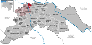
| Location of the municipality of Barum in the Lüneburg district | ||
  |
||


Barum is a municipality in the Lüneburg Heath in the district of Lüneburg , Lower Saxony (Germany). The municipality of Barum is a member municipality of the joint municipality of Bardowick .
geography
Geographical location
Barum, a place in the middle of the Lüneburg Elbmarsch , is centrally located to the cities of Lüneburg (about 13 km), Winsen (about 16 km), Lauenburg (about 18 km) and Geesthacht (about 15 km) as well as to Hamburg (about 40 km). It's about six kilometers to the Elbe. The village is traversed by the Neetze river, which widens like a lake to the north and is therefore called the Barumer See . The Neetze Canal, built at the end of the 19th century, branches off from the Neetze.
Community structure
The municipality of Barum consists of the districts Barum, Horburg and St. Dionys .
Incorporations
On March 1, 1974, on the occasion of the regional reform in Lower Saxony, the communities Horburg and St. Dionys were incorporated.
politics
The municipality of Barum belongs to the state electoral district 49 Lüneburg and to the federal electoral district 38 Lüchow – Dannenberg – Lüneburg .
Municipal council
The council of the municipality of Barum consists of eleven members:
| SPD | CDU | Alliance 90 / The Greens | Independent voter community Barum e. V. (UWG) | FDP | total | |
| 2011 | 4th | 4th | 1 | 2 | - | 11 seats |
| (31.7%) | (38.9%) | (11.4%) | (16.2%) | (1.4%) | ||
| 2016 | 3 | 5 | 2 | - | 1 | 11 seats |
| (30.8%) | (45.9%) | (18.2%) | - | (5.1%) |
2011: Preliminary results of the local elections on September 11, 2011 2016: Preliminary results of the local elections on September 11, 2016
mayor
- 1974–1999: Gerd Steinbach (CDU)
- 1999–2011: Werner Meyn (CDU)
- 2011–2018: Torsten Rödenbeck (CDU)
- Since 2018: Dr. Joachim Schwerdtfeger (FDP)
coat of arms
In silver, a blue wavy head, on the right a blue mill iron , on the left the turned crook of a blue crosier and below a leafy, blue cattail. The Wellengöpel indicates the many waterways that run through the municipality and at the same time shows that the municipality is made up of three districts. The mill iron stands for the district of Barum, the crosier for St. Dionys, the cattail for Horburg .
Place names
The old names were 1290 in Berne, 1304 in Barem, 1305 in Barme, 1319 in villa Barme, 1344 uilla Barem, 1348 to / van Barum, 1354 in Barem, 1366 van Barum, 1384 to Barem. The Low German dialect dictionaries list under barme, berme several interpretations, such as ditch edge, dyke river, embankment, step on the dike, the bottom, "the foot of the dike". Barum lies on a relatively narrow elevation protruding from the Neetze. It therefore applies to Barum in the Lüneburg district "settlement near" or "on a hill".
traffic
Barum is on the district roads 12 ( Wittorf –Barum) and 1 ( Tespe –Barum– Brietlingen ). By the bus lines 5405 (Marsch eight-Tespe- Horburg -Barum-Wittorf- Luneburg ) and 5904 (Horburg-Barum Brietlingen-Schulzentrum Scharnebeck ) of HVV is connected to the regional transport network Barum. From 2010 to 2014, line 4400 (Barum – Tespe– Marschacht - Rönne - Hamburg-Bergedorf station ) also ran directly to Barum. The connection was discontinued in December 2014 and only runs as far as Bütlingen.
education
The community has a single primary school as a branch of the Bardowick primary school, a kindergarten and, since 2013, a crèche . There are then secondary schools in Bardowick , Scharnebeck and Lüneburg. Since 2007 a youth center has been available in the adjoining building of the school and the kindergarten.
Web links
- official homepage
- District Horburg
- Information platform about the municipality of Barum
- Homepage of the youth center Barum
Individual evidence
- ↑ State Office for Statistics Lower Saxony, LSN-Online regional database, Table 12411: Update of the population, as of December 31, 2019 ( help ).
- ↑ On the regional and administrative reform read in detail Blazek, Matthias: Von der Landdrostey zur Bezirksregierung - The history of the district government Hanover in the mirror of administrative reforms, Stuttgart 2004, ISBN 3-89821-357-9 .
- ^ Federal Statistical Office (ed.): Historical municipality directory for the Federal Republic of Germany. Name, border and key number changes in municipalities, counties and administrative districts from May 27, 1970 to December 31, 1982 . W. Kohlhammer GmbH, Stuttgart / Mainz 1983, ISBN 3-17-003263-1 , p. 234 .
- ↑ http://www.bardowick.de/Portaldata/15/Resources/kommunal_daten/kommunal_dokumente/wahlen_2011/Barum_-_Diagramm,_Vergleich.jpg
- ↑ Election 2011: Municipality of Barum . gemeinde-barum.de. Accessed September 24, 2015. 2016 election: Distribution of seats in Barum 2016 . bardowick.de. Retrieved September 14, 2016.
- ↑ Place names at NDR .de .
- ↑ [1]
- ↑ [2]
- ↑ [3]
- ↑ [4] .

Cities: Bleckede | Luneburg . Other communities: Adendorf | Amelinghausen | Neuhaus Office | Artlenburg | Bardowick | Barendorf | Barnstedt | Barum | Betzendorf | Boitze | Brietlingen | Dahlem | Dahlenburg | German Evern | Echem | Embsen | Handorf | Hittbergen | Hohnstorf (Elbe) | Kirchgellersen | Lüdersburg | Mechtersen | Melbeck | Nahrendorf | Networks | Oldendorf (Luhe) | Broken wheel | Rehlingen | Reinstorf | Reppenstedt | Rullstorf | Scharnebeck | Soderstorf | Südergellersen | Thomasburg | Tosterglope | Vastorf | Birds | Wendisch Evern | Westergellersen | Wittorf .