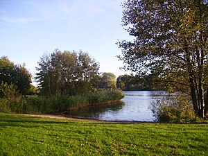
Barum Lake
| Barum Lake | ||
|---|---|---|

|
||
| Barumer See in September 2006 | ||
| Geographical location | Barum (Lüneburg district) , Lower Saxony | |
| Tributaries | Nets | |
| Drain | Nets | |
| Places on the shore | Barum (district of Lüneburg) | |
| Location close to the shore | Lüneburg , Lauenburg / Elbe , Winsen (Luhe) | |
| Data | ||
| Coordinates | 53 ° 21 '3 " N , 10 ° 24' 49" E | |
|
|
||
| Altitude above sea level | 4 m | |
| surface | 13.7 ha | |
| length | 1.2 km | |
| width | 100 m | |
| Maximum depth | 4 m | |
| PH value | 8.1 | |
|
particularities |
Sea-like river expansion |
|
The Barumer See is a lake-like river expansion of the Neetze in the Lüneburg Elbmarsch in the Lower Saxony district of Lüneburg . The Neetze connects the lake with the neighboring Reihersee .
The lake is located in a recreational area . It is used as a swimming lake , with a barbecue area on the neighboring site of a youth hostel and a wide range of leisure activities for families.
The Barumer See is used by the Sport Anglers Association Hamburg eV as fishing waters.
See also
Web links
Commons : Barumer See - Collection of images, videos and audio files
Individual evidence
- ↑ www.anglermap.de: Water profile Barumer See (accessed on November 7, 2014)
- ↑ www.anglermap.de: Water profile Barumer See (accessed on November 7, 2014)
- ^ Bathing water atlas Lower Saxony: Barumer See (n = 25 values, 2006-2009) (accessed on November 7, 2014)
