
Wriedel
| coat of arms | Germany map | |
|---|---|---|

|
Coordinates: 53 ° 2 ′ N , 10 ° 19 ′ E |
|
| Basic data | ||
| State : | Lower Saxony | |
| County : | Uelzen | |
| Joint municipality : | Bevensen-Ebstorf | |
| Height : | 64 m above sea level NHN | |
| Area : | 104.48 km 2 | |
| Residents: | 2354 (Dec. 31, 2019) | |
| Population density : | 23 inhabitants per km 2 | |
| Postal code : | 29565 | |
| Area code : | 05829 | |
| License plate : | UE | |
| Community key : | 03 3 60 029 | |
| Community structure: | 9 districts | |
| Association administration address: | Lindenstrasse 12 29549 Bad Bevensen |
|
| Mayor : | Jörg Peter ( CDU ) | |
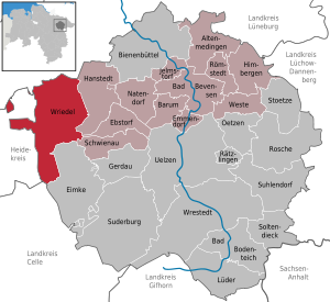
| Location of the municipality of Wriedel in the district of Uelzen | ||
  |
||

Wriedel is a municipality in the middle of the Lüneburg Heath in the district of Uelzen , Lower Saxony . The municipality of Wriedel belongs to the integrated municipality of Bevensen-Ebstorf . At the end of 2013, Wriedel had 2,433 inhabitants.

geography
Geographical location
Wriedel lies in a heathland area with a few hills: Westberg (105.5 m), Sultberge (102 m), Schiffberg (101 m), Pracherberg (100 m), Schaperberg (97.8 m), Gannerberg (89 m), Kolkenberg (99 m), Krähenberg (91.5 m), Kreuzberg near Schatensen (89.9 m), Osterberg near Brockhöfe (89 m), Kreuzberg near Wriedel (85.7 m), Osterberg near Holthusen I (86.5 m ), Mühlenberg (81.4 m).
The Wriedeler Bach and the Schwienau flow through the municipality .
Community structure
The municipality includes the districts and residential areas Arendorf, Arnoldshof, Brambostel, Brockhöfe, Brockhöfe train station, Bruch, Grenzhof, Heidehof, Holthusen I, Langlingen, Lintzel, Schatensen, Wense settlement, Wettenbostel, Wriedel and Wulfsode.
history
First mention
The places of the community - documented - were founded around 1200, Wriedel itself around the year 1100.
Incorporations
On July 1, 1972, the communities Arendorf, Brambostel, Brockhöfe, Holthusen I , Lintzel, Schatensen, Wettenbostel and Wulfsode were incorporated.
religion
The Heideort Wriedel forms the center of two Protestant parishes:
- the Evangelical Lutheran parish of the Hanoverian regional church with the Suidbert church
- the independent Evangelical Lutheran Bethlehem Community, which is part of the Lower Saxony East church district of the Independent Evangelical Lutheran Church . This is used by the Bethlehem Church.
politics
Municipal council
The municipal council of Wriedel consists of 13 councilors, including the part-time mayor.
| SPD | CDU | FDP | Independent Voting group Ebstorf (UWE) | independent | total | |
| 2006 | 3 | 10 | 0 | 0 | 0 | 13 seats |
| 2011 | 3 | 8th | 1 | 1 | 0 | 13 seats |
| 2016 | 2 | 8th | 1 | 1 | 1 | 13 seats |
Last local election on September 11, 2016.
Mayor / Administration
Mayor is Jörg Peter (CDU). The municipal administration is located in Hauptstraße 19.
Economy and Infrastructure
Merchants and craftsmen , two general practitioners , a dentist, a lawyer, a pharmacy and a discounter ( NP-Markt ) are on site.
Motor vehicle workshops complement the infrastructure .
There is also a watchmaking master workshop and a gunsmith's shop in town.
Agriculture is at the core . There are four full farms and several part-time businesses in Wriedel.
The local communities are supported by several associations and the volunteer fire brigades . The fire brigades provide fire protection and general help.
traffic
Wriedel lies at the intersection of the roads from Celle to Lüneburg and Amelinghausen and from Uelzen to Soltau and Bad Fallingbostel . In the Brockhöfe district there is a stop on the Uelzen – Langwedel railway line . The main roads L234 and L250 are the most important connecting routes to the next towns. The place is on the federal road 71 and is about 40 km from the next motorway entrance.
leisure
The sports club TSV Wriedel, founded in 1912, has over 700 members, around 50% of which are young people. There is an outdoor swimming pool with natural clarification without chlorine additives, it is operated by the association “Naturbad Wriedel e. V. “A rifle house in Brockhöfe belongs to the Kyffhäuser Kameradschaft Wriedel e. V. The riding and driving club is active around horses.
Other clubs:
- Country youth Wriedel
- Quad Club Lintzel
- Men's choir
- Trombone Choir Wriedel-Hanstedt
- mixed choir
- Wulfs or clan
education
There is a primary school and a kindergarten in Wriedel.
Attractions
Sights are the Wulfsoder sheepfold, the Ellerndorfer Heide, the Naturbad Wriedel eV, Burg Bode and the Villa Waldheim.
literature
- Heinrich Porth: The families and residents of the parish Wriedel: Ortsfamilienbuch 1758-1875 and study of population history . To the places Arendorf, Brockhöfe, Holthusen I, Langlingen, Lintzel, Lopau, Schatensen, Wriedel and Wulfsode. Uelzen: Museum and Heimatverein des Kreis Uelzen 2007, ISBN 3-929864-12-6 (= sources and representations on the history of the city and district of Uelzen 7).
Individual evidence
- ↑ State Office for Statistics Lower Saxony, LSN-Online regional database, Table 12411: Update of the population, as of December 31, 2019 ( help ).
- ^ Federal Statistical Office (ed.): Historical municipality directory for the Federal Republic of Germany. Name, border and key number changes in municipalities, counties and administrative districts from May 27, 1970 to December 31, 1982 . W. Kohlhammer GmbH, Stuttgart / Mainz 1983, ISBN 3-17-003263-1 , p. 237 .
- ^ Result of local elections 2006
- ^ Result of local elections 2011
- ^ Result of local elections 2016
Web links
Altenmedingen | Bad Bevensen | Bad Bodenteich | Barum | Beehive | Ebstorf | Eimke | Emmendorf | Gerdau | Hanstedt | Himberg Mountains | Jelmstorf | Lüder | Natendorf | Oetzen | Rätzlingen | Römstedt | Roshe | Schwienau | Soltendieck | Stoetze | Suderburg | Suhlendorf | Uelzen | Vest | Wrestedt | Wriedel