Schwienau (river)
| Schwienau | ||
| Data | ||
| location | Lower Saxony , Germany | |
| River system | Elbe | |
| Drain over | Gerdau → Ilmenau → Elbe → North Sea | |
| source | In the Lüneburg Heath near Wriedel 53 ° 1 ′ 14 ″ N , 10 ° 16 ′ 59 ″ E |
|
| Source height | 73 m above sea level NHN | |
| muzzle | At Groß Süstedt in the Gerdau coordinates: 52 ° 58 '17 " N , 10 ° 23' 23" E 52 ° 58 '17 " N , 10 ° 23' 23" E |
|
| Mouth height | 48 m above sea level NHN | |
| Height difference | 25 m | |
| Bottom slope | 1.3 ‰ | |
| length | 19 km | |
| Catchment area | 171.4 km² | |
| Left tributaries | Wriedeler Bach , Oechtringer Bach | |
| Communities | Brockhöfe, Bode, Hanstedt I , Ebstorf , Wittenwater, Stadorf, Linden, Groß Süstedt | |
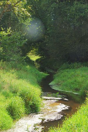
The Schwienau is a 19 km long left tributary of the Gerdau . It rises in the Weidebruch north of Brockhöfe near Wriedel and flows northwest of Groß Süstedt into the Gerdau. At first it flows through a natural green landscape. But after just 2.5 kilometers it is straightened and led past a pumping station.
After about 9 kilometers, the Oechtringer Bach flows into it from the north as an almost equally large and slightly longer tributary . The Schlingbach, which flows into Ebstorf, loses its water completely in the middle section through the permeable subsoil to the approximately 20 meters lower flowing tributaries of the Ilmenau in the northwest. If the middle section weren't dry, it would be the longest side stream of Schwienau.
The Schwienau is mostly straightened and rarely flows naturally. The adjacent agricultural use usually reaches close to the shore. Only near Wriedel and east of it does it run through small forests and unused heathland. As a fluvial sediment load , it mainly carries sand and mud with it. This provides a habitat especially for leeches , snails , water scorpions and amphipods . The water is generally moderately polluted (quality class II). The Schwienau flows into the Gerdau near Groß Süstedt, although it has more water here than the Gerdau, is a good 5 kilometers longer and, at least above ground, has a catchment area that is 2.4 times larger .
Tributaries
Individual evidence
- ↑ Topographic map 1: 25,000
- ^ Ilmenau source water quality
