
Osterholz district
| coat of arms | Germany map |
|---|---|

|

Coordinates: 53 ° 15 ' N , 8 ° 49' E |
| Basic data | |
| State : | Lower Saxony |
| Administrative headquarters : | Osterholz-Scharmbeck |
| Area : | 650.81 km 2 |
| Residents: | 113,928 (Dec. 31, 2019) |
| Population density : | 175 inhabitants per km 2 |
| License plate : | OHZ |
| Circle key : | 03 3 56 |
| NUTS : | DE936 |
| Circle structure: | 11 municipalities |
| Address of the district administration: |
District building I Osterholzer Straße 23 27711 Osterholz-Scharmbeck District building II Am Osterholze 2a 27711 Osterholz-Scharmbeck |
| Website : | |
| District Administrator : | Bernd Lütjen ( SPD ) |
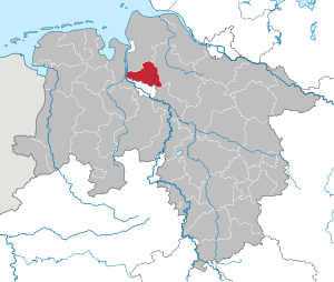
| Location of the district of Osterholz in Lower Saxony | |
  |
|
The district of Osterholz ( Lower German district of Oosterholt ) is located in northern Lower Saxony in the north-west metropolitan region . Its district town is Osterholz-Scharmbeck .
geography
location
The north and west of the district is shaped by the Osterholzer Geest , the east belongs to the lowlands of Hamme and Wümme with the Teufelsmoor, which has largely been cultivated since the 18th century . In the far west, the district extends with the Osterstader Marsch to the Weser.
structure
Communities
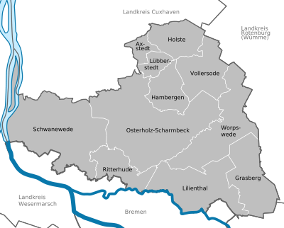

The number of inhabitants on December 31, 2019 in brackets.
|
Joint municipality with its member municipalities:
|
Former parishes
The following list contains all former municipalities that ever belonged to the Osterholz district.
Neighboring areas
The district borders clockwise to the north, beginning with the districts of Cuxhaven , Rotenburg (Wümme) and Verden (all in Lower Saxony), the urban area of Bremen (and thus the state of Bremen ) and the Wesermarsch district (west of the Weser , again in Lower Saxony).
Historical and institutional catchment areas
In terms of historical development, the Osterholz district is part of the former Bremen-Verden territory , which stretched across the Elbe-Weser triangle . In addition to the Osterholz district , this includes the current districts of Cuxhaven , Rotenburg (Wümme) , Stade and Verden . Many catchment areas of ecclesiastical, cultural, societal or social institutions such as the Chamber of Commerce, Protestant church district , landscape association and others are still based on the borders of this historical area. The territory of Bremen-Verden later formed a continuity with the Landdrostei Stade and the administrative district of Stade . The latter disappeared in 1978 in the enlarged administrative district of Lüneburg, which had also no longer existed in 2004 .
climate
| Osterholz district | ||||||||||||||||||||||||||||||||||||||||||||||||
|---|---|---|---|---|---|---|---|---|---|---|---|---|---|---|---|---|---|---|---|---|---|---|---|---|---|---|---|---|---|---|---|---|---|---|---|---|---|---|---|---|---|---|---|---|---|---|---|---|
| Climate diagram | ||||||||||||||||||||||||||||||||||||||||||||||||
| ||||||||||||||||||||||||||||||||||||||||||||||||
|
Osterholz district
Source: DWD, data: 1971–2000
|
history
Founding and development until 1939
The district takes its name Osterholz thanks to the former monastery (1184-1650) in the county seat, the basilica as a monastery church of St. Mary is preserved. Until the Thirty Years War, the monastery, like the neighboring Lilienthal monastery, was part of the Archbishopric of Bremen , which later became part of the Duchy of Bremen-Verden in a secularized manner . In the course of secularization, offices emerged from the monasteries and became official political communities in the Electorate of Hanover from 1719 . From 1823 the Osterholz office and the Lilienthal office were part of the Landdrostei Stade in the Kingdom of Hanover .
A district of Osterholz , also known as the steering committee , was founded on October 1, 1867 from the former Hanover offices of Osterholz , Blumenthal and Lilienthal for military and tax administration purposes. General administration remained a matter for the old offices. After the Landdrostei Stade was converted to the new administrative district of Stade on April 1, 1885, the Osterholz district was formed from the offices of Osterholz and Lilienthal within the framework of the new district regulations for the province of Hanover. The Blumenthal office together with parts of the Hagen office now formed the Blumenthal district .
The Osterholz district initially comprised 109 communities, of which a larger number was incorporated into larger neighboring communities in the 1920s due to their small population. In addition, in 1927 the churches were Osterholz , Scharmbeck , Bargten , Ahrensfelde and sand Beckerbruch the spots together Osterholz-Scharmbeck, which received its charter on 25 October 1929th
During the Prussian district reform of 1932, the Blumenthal and Osterholz districts were combined into a new and larger district of Osterholz . The number of parishes in the district was reduced in 1936 and 1937 through a series of mergers. With the communities of Aumund , Blumenthal , Farge , Grohn , Lesum and Schönebeck , the district of Osterholz had to surrender part of the old district of Blumenthal to the city of Bremen on November 1, 1939 , thereby losing a large part of the inhabitants that had been gained in 1932.
National Socialist rule until 1945
In Löhnhorst (today part of the community Schwanewede ), the Hohehorst des Lebensborn home was operated during the National Socialist era . During the Nazi era, the Farge / Schwanewede area was dominated by naval armaments and forced labor . For the construction of three major military construction projects for the navy - two large tank farms and the “Valentin” submarine bunker - up to 12,000 people were employed here at times. While German workers and volunteers recruited abroad were mainly employed before the Second World War , foreign forced laborers were added after the war began . In the course of the war, Gestapo prisoners from the Farge labor education camp and prisoners of war from the Stalag XB Sandbostel were also deployed on the large construction site . In Schwanewede, on the grounds of the Farge tank farm, there was also a satellite camp of the Neuengamme concentration camp , in which concentration camp inmates were held for the construction of the “Valentin” submarine bunker . The documentation and learning location Baracke Wilhelmine in the Schwaneweder district of Neuenkirchen is a reminder of this. There was another satellite camp of the Neuengamme concentration camp in Lübberstedt-Bilohe. The 500 women from Hungary deployed there originally came from the Auschwitz concentration camp and had to work in the ammunition manufacture at the Lübberstedt air ammunition facility (MUNA). The MUNA Lübberstedt working group has dealt with the history of the subcamp and the forced labor in the main air ammunition facility. Until 2009 there was a Bundeswehr depot on the MUNA site.
post war period
The regional reform in Lower Saxony began for the district of Osterholz in 1968, when Eickedorf , Grasberg and Wörpedorf were merged to form a new municipality of Grasberg. A comprehensive regional reform was carried out by the law on the reorganization of the communities in the Osterholz / Wesermünde area on March 1, 1974. The district area was enlarged by the fact that the Weser island Harriersand and the Hammelwarder Sand area from the Wesermarsch district and the communities Axstedt and Lübberstedt from the Wesermünde district came to the district of Osterholz. At the same time, numerous community mergers created the division of the district into the city of Osterholz-Scharmbeck and ten other communities.
In the 1970s and 1980s, the villages of Wilstedter Moor and Tarmstedter Moor from the Rotenburg (Wümme) district were incorporated into Grasberg.
Population development
The figures in the following tables come from the more detailed table of the former Stade administrative district , the sources given there and the municipal directory from 1900 and for 1904 from the Chronicle of Osterholz-Scharmbeck.
| Population up to 1970 | 1890 | 1900 | 1904 | 1910 | 1925 | 1933 | 1939 | 1950 | 1961 | 1969 | 1970 |
|---|---|---|---|---|---|---|---|---|---|---|---|
| Blumenthal | 22,547 | 30,353 | 39,535 | 43.104 | |||||||
| Osterholz | 28,232 | 29.205 | 29,471 | 31,284 | 32,545 | 80.216 | 41,529 | 73,407 | 71,643 | 80,600 | 82.191 |
| Population from 1980 | 1980 | 1987 | 1990 | 1998 | 2002 | 2006 | 2012 |
|---|---|---|---|---|---|---|---|
| Osterholz | 93,700 | 94.196 | 96,000 | 108.084 | 111.992 | 112,498 | 110,816 |
| Area (km²) | 1900 | 1932 | 1950 | 2000 | 2012 |
|---|---|---|---|---|---|
| Blumenthal | 175 | ||||
| Osterholz | 478 | 653 | 620 | 651 | 651 |
Religions
Christianity
Traditionally, the area of today's Osterholz district is evangelical-Lutheran . The parishes belong to the regional church of Hanover . Especially after the war, large Catholic parishes have formed, which belong to the diocese of Hildesheim , due to the influx of many expellees, guest workers from southern Europe and repatriates from east-central and eastern Europe . Due to the high number of people leaving the church, both large Christian churches are subject to restructuring processes.
Furthermore, members of free churches , Jehovah's Witnesses , Jews , Muslims and atheists live in the district .
Denomination statistics
According to the 2011 census, 55.8% of the population were Protestant and 6.4% Roman Catholic at the beginning of 2011 . 37.8% belonged to other denominations or religious communities or were non-denominational . The total number of Protestants at the end of 2018 was 51,866 (45.6%) out of a total population of 113,517. In 2019 the number of members fell to 51,697 (45.4%) with a total of 113,928 inhabitants.
politics
District council
| Parties and constituencies | Percent 2016 |
Seats 2016 |
Percent 2011 |
Seats 2011 |
Percent 2006 |
Seats 2006 |
Percent 2001 |
Seats 2001 |
|
|---|---|---|---|---|---|---|---|---|---|
| SPD | Social Democratic Party of Germany | 32.96 | 15th | 38.03 | 17th | 43.33 | 20th | 42.61 | 21st |
| CDU | Christian Democratic Union of Germany | 30.82 | 14th | 29.14 | 13 | 33.43 | 15th | 33.36 | 16 |
| Green | Alliance 90 / The Greens | 12.28 | 6th | 18.96 | 9 | 9.70 | 5 | 6.96 | 4th |
| FDP | Free Democratic Party | 2.73 | 1 | 2.04 | 1 | 6.47 | 3 | 5.21 | 2 |
| left | The left | 5.51 | 3 | 3.54 | 2 | 2.86 | 1 | ||
| Flat share | Community of voters | 1.10 | 0 | 2.37 | 1 | 2.11 | 1 | 4.12 | 3 |
| BF | Citizens Group | 3.67 | 2 | 3.78 | 2 | 1.46 | 1 | 2.69 | 1 |
| DL | THE LILIENTHALER | 2.37 | 1 | ||||||
| WSH | Voting community for the Hambergen community | 0.61 | 0 | 1.23 | 0 | ||||
| Single nomination Asmus | 0.11 | 0 | |||||||
| REP | The Republicans | 1.01 | 0 | ||||||
| UWG / UKA | Independent voter community Worpswede / Independent local political working group Hambergen | 1.55 | 0 | ||||||
| UWG | Independent voter community | 1.08 | 0 | ||||||
| AfD | Alternative for Germany | 9.15 | 4th | ||||||
| NPD | National Democratic Party of Germany | 0.47 | 0 | ||||||
| Lateral thinker | Voting group lateral thinkers Lilienthal | 1.26 | 1 | ||||||
| total | 100 | 46 | 100 | 46 | 100 | 46 | 100 | 46 | |
| Turnout in percent | 55.82 | 52.09 | 53.01 | 57.21 | |||||
Last local election on September 11, 2016
The next local election in Lower Saxony will take place in September 2021.
District administrators and (senior) district directors
| District Administrator | from | to | Political party | out | ||||
|---|---|---|---|---|---|---|---|---|
| 1. | August Lange | June 11th | 1945 | - | the 14th of March | 1946 | SPD | Osterholz-Scharmbeck |
| 2. | Louis Biester | March, 15 | 1946 | - | October 31 | 1946 | SPD | Teufelsmoor (location) |
| 3. | Wilhelm Ahrens | November 1st | 1946 | - | March 31 | 1949 | NLP / DP | Lilienthal |
| 4th | Johann Christian Evers | April 1st | 1949 | - | May 4th | 1964 | DP | Ritterhude |
| 5. | Hinrich Winters | 8th June | 1964 | - | January 14th | 1968 | CDU | Lilienthal |
| 6th | Walter Schlueter | 15. January | 1968 | - | 20th November | 1972 | SPD | Osterholz-Scharmbeck |
| 7th | Heinrich Blanke | 30th of November | 1981 | - | 20th November | 1991 | CDU | Grasberg |
| 8th. | Ludwig Waetjen | 21st November | 1991 | - | December 31 | 2004 | SPD | Osterholz-Scharmbeck |
| 9. | Jörg Mielke | January 1st | 2005 | - | 19th of February | 2013 | Independent / SPD | Osterholz-Scharmbeck |
| 10. | Bernd Luetjen | September 27th | 2013 | - | September 27th | 2021 | SPD | Hambergen |
Since January 1, 2005, Jörg Mielke was the first elected district administrator since the introduction of the "single track" administration in the Osterholz district. On November 11, 2011, he was re-elected with 85.46 percent of the vote (2004: 62.26%); In contrast to 2004, there were two opposing candidates: Oliver Koller (FDP 8.39%) and Norbert Weber (Die Linke 5.96%). His election was supported by the SPD in 2004 and by the SPD and CDU in 2011. Jörg Mielke has headed the State Chancellery in Hanover since February 19, 2013 . His successor, Bernd Lütjen, was elected at the same time as the federal election on September 22, 2013 with 56.92% and has been in office since September 27, 2013 and can stand for re-election after eight years in 2021 . His deputies are Tim Jesgarzewski (SPD), Brunhilde Rühl (CDU) and André Hilbers (GREEN).
(Senior) District Directors
| (Senior) District Directors | from | to | ||||
|---|---|---|---|---|---|---|
| 1. | Hinrich Horstmann | June 21st | 1946 | - | October 31 | 1946 |
| 2. | Otto Stegemann | 6th January | 1947 | - | December 31 | 1953 |
| 3. | Hermann Brünjes (acting head of office) | January 1st | 1954 | - | 30. September | 1954 |
| 4th | Jasper-Wilhelm Gottschalk | January 1st | 1954 | - | 30th May | 1974 |
| 5. | Hans-Dieter von Friedrichs | June 1st | 1974 | - | December 31 | 2004 |
coat of arms
The municipal coat of arms was awarded to the Osterholz district on April 25, 1936.
|
|
Blazon : "On wavy blue sign foot , in a horizontal, right beard of upstream silver keys , silver a black Torfkahn with sailing ." |
| Foundation of the coat of arms: The district area consists of a third of moorland. These were cultivated and settled around 200 years ago. The people living there have been mining the moor for decades and selling the peat obtained in this way as fuel. The peat barge was used for transport with a sail blackened with tar and fat. The peat barge was led through a widely branched canal system into the local rivers such as Hamme , Wörpe and Wümme and from there on over the Lesum into the Weser . The Stader key is intended to symbolize the fact that the local district area was part of the administrative district of Stade from the middle of the 17th century until 1978 . The coat of arms can also be derived from the coat of arms of the Archbishopric of Bremen . |
Partnerships
- Since April 2006 there has been a partnership with the Polish district of Marienwerder ( Powiat Kwidzyński ). Both circles have established a connection via the EU project Baltic Rural Broadband , which deals with the expansion of broadband technology in rural areas. Around 80,200 inhabitants live in Kwidzyn on around 834 km², around half of them in the town of the same name.
- The district is represented in the Lower Saxony / Bremen municipal association.
Culture and sights
Natural monuments and protected areas
In addition to landscape protection areas and natural monuments, there are 17 designated nature reserves in the district (as of February 2017).
See also:
- List of nature reserves in the Osterholz district
- List of landscape protection areas in the district of Osterholz
- List of natural monuments in the district of Osterholz
- List of protected landscape components in the district of Osterholz
Museums
Institutions
- Landschaftsverband Stade , registered association for the maintenance of cultural institutions
Economy and Infrastructure
In the shadow of the regional center of Bremen , it was already established in 1970 that the Osterholz district had lagged behind the industrial development of other Lower Saxony districts, including a consequence of the regional reform of 1939 with the abandonment of the more developed communities (Aumund, Blumenthal, Farge, Grohn, Lesum and Schönebeck) 75% of the industry was lost to Bremen. Due to the lack of location requirements and the proximity to Bremen, the Osterholz district has not been able to compensate for this loss to this day.
According to the regional ranking of the Initiative Neue Soziale Marktwirtschaft (INSM) in 2009, the district was 98th out of 409 districts examined for purchasing power and 391th for economic output; d. H. 16,576 euros per inhabitant in terms of gross domestic product are below average compared to the national average of 28,534 euros. In Lower Saxony this means 44 out of 46 ranks.
It is therefore u. a. relied on tourism concepts, especially in Teufelsmoor , as there is still potential for growth here; the district with 1.1 guests per inhabitant only ranks 372 out of 391 districts examined. This is rank 40 out of 46 districts in Lower Saxony.
Because of its proximity to Bremen, the district of Osterholz is a so-called conurbation; in particular, the neighboring communities of Schwanewede, Ritterhude and Lilienthal have been able to increase their population numbers considerably by moving in from Bremen.
Unemployment and social statistics
The Osterholz district is one of the option municipalities . The care of the long-term unemployed under unemployment benefit II is not provided by the employment agency , but by the district. The promotion and placement of this group of people is carried out by ProArbeit , a communal institution under public law (kAöR), the performance and basic security by the municipalities of the district. In November 2007, 2,108 (64.7%) of a total of 3,259 unemployed were dependent on ALG II.
Unemployment rate
The district's labor market is closely linked to the economic development in Bremen, as many of the district's residents commute to Bremen . The commuter rate is −14.4%.
The district's unemployment rate generally follows the federal trend:
- 2003: 7.6%
- 2005: 9.4%
- 2008: 5.8%
- May 2014: 4.5%
The breakdown by gender gives z. For example, for January 2006, of 4,976 unemployed, 2,706 (54.4%) were men and 2,270 (45.6%) women. The number of reported vacancies ranges between 300 and 350; so it was in May 2014: 348.
In June 2010, 10% of the unemployed were under 25, broken down by age group; 30% were 50 years or older; 9.8% came from abroad: 3.5% were considered severely disabled.
Healthcare
The district town of Osterholz-Scharmbeck and the community of Lilienthal are locations for acute hospitals. In Osterholz-Scharmbeck this is the Osterholz district hospital , in Lilienthal there are the residence clinics , which were formerly owned by the church and have now been taken over by a private institution after insolvency proceedings.
traffic
Street
The A 27 motorway runs through the district in a south-north direction from Walsrode via Bremen, Ritterhude and Schwanewede to Bremerhaven and Cuxhaven .
railroad
- Ritterhude , Osterholz-Scharmbeck , Lübberstedt and Hambergen lie on the Bremen – Bremerhaven railway line from south to north .
- In Osterholz-Scharmbeck, the Stade – Osterholz-Scharmbeck railway, operated by the railways and transport companies Elbe-Weser , branches off in the direction of Worpswede , Bremervörde and Stade , which is currently only used for tourism by the so-called Moorexpress .
- Schwanewede is affected by the Farge-Vegesacker railway in the Beckedorf district . Due to the naval railway, the place itself had several train stations for passenger traffic. For years, however, the route was only used by the Bundeswehr . On December 16, 2007, as part of the preparations for the Bremen / Lower Saxony Regional S-Bahn, local public transport on the route with diesel multiple units was resumed. The line was electrified in 2011. With the exception of individual journeys during rush hour, transfer-free travel options are available to Bremen main station and Verden.
tram
- The community of Lilienthal has been connected to the Bremen tram network with line 4 since August 1, 2014 .
License Plate
On July 1, 1956, the district was assigned the distinctive sign OHZ when the vehicle registration number that is still valid today was introduced . It is still issued today.
literature
- Jens Murken: "The story is like a lie to tell, but what is it ...". The district of Osterholz 1932–1948. Conversation with contemporary history . Agenda-Verlag, Münster 1999, ISBN 3-89688-047-0
- Johann Segelken: Osterholz-Scharmbecker Heimatbuch . 1934; 4th edition: Saade, Osterholz-Scharmbeck 1987, ISBN 3-922642-18-7
- District administration Osterholz (Ed.): The district of Osterholz . Stalling, Oldenburg 1970
Web links
Individual evidence
- ↑ State Office for Statistics Lower Saxony, LSN-Online regional database, Table 12411: Update of the population, as of December 31, 2019 ( help ).
- ^ The district of Osterholz. (PDF; 22.5 kB) (No longer available online.) In: Website Landkreis Osterholz. 2006, archived from the original on September 27, 2007 ; accessed on April 20, 2019 .
- ↑ State Office for Statistics Lower Saxony, LSN-Online regional database, Table 12411: Update of the population, as of December 31, 2019 ( help ).
- ↑ a b data on the Osterholz district at territorial.de.
- ↑ a b Michael Rademacher: German administrative history from the unification of the empire in 1871 to the reunification in 1990. Osterholz.html. (Online material for the dissertation, Osnabrück 2006).
- ↑ a b table: municipalities in Hanover.
- ^ German weather service: Climate information Osterholz. World Meteorological Organization, accessed January 4, 2013 .
- ^ District regulations for the province of Hanover (1884).
- ^ Community encyclopedia for the Free State of Prussia: Province of Hanover Verlag des Prussian State Statistical Office, 1930.
- ^ Prussian State Ministry, § 72, Ordinance on the reorganization of rural districts. August 1, 1932 Prussian Law Collection, Berlin 1932; No. 43 (Formation of the new district of Osterholz) , R. von Deckers Verlag, G. Schenk, 1932.
- ↑ Fourth ordinance on the rebuilding of the Reich of September 28, 1939.
- ^ Family Lahusen. ( Memento from March 4, 2016 in the Internet Archive )
- ^ Bunker Valentin.
- ↑ Website - documentation and learning location barrack wilhelmine
- ↑ Guided tours through the former MUNA Lübberstedt
- ^ Rüdiger Kahrs: The evacuation of the subcamp Lübberstedt near Bremen to Ostholstein 1945. An event sketch digitized
- ↑ Use of the MUNA Lübberstedt after 1945
- ^ Law on the amalgamation of the communities of Eickedorf, Grasberg and Wörpedorf. December 28, 1967.
- ↑ Law on the reorganization of the communities in the Osterholz / Wesermünde area. June 13, 1973.
- ^ Chronicle of Osterholz-Scharmbeck, Volume I. From the beginning to 1929. Ed. Stadt Osterholz-Scharmbeck, p. 251.
- ↑ Population in regional comparison by religion. Retrieved September 10, 2019.
- ↑ More and more people are leaving the church. Retrieved September 10, 2019.
- ↑ Fewer church members
- ↑ District Osterholz - overall results of the district election 2016. In: Website Zweckverband Kommunale Datenverarbeitung Oldenburg (KDO). September 11, 2016, accessed July 9, 2020 .
- ↑ District Council. In: Website of the district of Osterholz. Retrieved July 9, 2020 .
- ↑ a b Erich Dieter Lindner, Günter Olzog: The German districts - coat of arms, history, structure . Günter Olzog Verlag, Munich 1986, ISBN 3-7892-7278-7 , p. 177 .
- ↑ a b c d Regional ranking: Profile Osterholz. ( Memento from April 19, 2010 in the Internet Archive ) Initiative New Social Market Economy 2009.
- ↑ a b Employment Agency
- ^ Integration report for the Osterholz district. The district administrator of March 28, 2008.
- ^ A b Regional information - statistics of the Federal Employment Agency. In: statistik.arbeitsagentur.de. Retrieved July 10, 2020.
- ↑ statistik.arbeitsagentur.de
- ↑ Osterholzer Kreisblatt No. 150 of July 1, 2010, unemployed: pink numbers in the Osterholz district. by Robert Schuhmann, p. 1.
- ^ Protestant press service : Bremen investor and doctors take over Martins hospital in Lower Saxony. ( Memento from July 19, 2011 in the Internet Archive ) February 13, 2009.
Counties : Ammerland | Aurich | Celle | Cloppenburg | Cuxhaven | Diepholz | Emsland | Friesland | Gifhorn | Goslar | Göttingen | County of Bentheim | Hameln-Pyrmont | Harburg | Heidekreis | Helmstedt | Hildesheim | Holzminden | Empty | Lüchow-Dannenberg | Lüneburg | Nienburg / Weser | Northeim | Oldenburg | Osnabrück | Osterholz | Peine | Rotenburg (Wümme) | Schaumburg | Stade | Uelzen | Vechta | Verden | Wesermarsch | Wittmund | Wolfenbüttel
Region : Hanover
Independent cities : Braunschweig | Delmenhorst | Emden | Oldenburg (Oldb) | Osnabrück | Salzgitter | Wilhelmshaven | Wolfsburg