
Holste
| coat of arms | Germany map | |
|---|---|---|

|
Coordinates: 53 ° 22 ' N , 8 ° 51' E |
|
| Basic data | ||
| State : | Lower Saxony | |
| County : | Osterholz | |
| Joint municipality : | Hambergen | |
| Height : | 24 m above sea level NHN | |
| Area : | 35.34 km 2 | |
| Residents: | 1397 (Dec. 31, 2019) | |
| Population density : | 40 inhabitants per km 2 | |
| Postal code : | 27729 | |
| Area code : | 04748 | |
| License plate : | OHZ | |
| Community key : | 03 3 56 004 | |
| Community structure: | 4 districts | |
| Association administration address: | Bremer Str. 2 27729 Hambergen |
|
| Mayor : | Gerhard Müller (Free Holster List FHL) | |
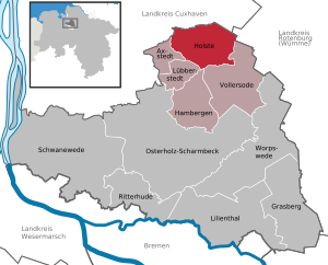
| Location of the municipality of Holste in the district of Osterholz | ||
  |
||

Holste is a municipality of the combined municipality of Hambergen and is located on the northern edge of the district of Osterholz in Lower Saxony ( Germany ).
geography
Geographical location
The municipality of Holste is located in the north German lowlands north of Bremen.
Community structure
The four districts of the municipality are:
- Hellingst
- Oldendorf
- Paddewish
- Cities
The name Holste is derived from the first letters of the sub-communities H ellingst, Ol dendorf and Ste den.
history
Waldheim Oldendorf
In Oldendorf there was a refugee camp in which, in 1945, 200 refugees from the former eastern regions were accommodated by the Osterholz district authorities. The camp was cleared in 1968. Today there is no longer any visible trace of it.
The quarters were built in 1938 by the Reich Labor Service and functioned as a "maiden camp" until the end of the war. "It wasn't a dreary slum camp," says Siegfried Begatik, who researched the "home of the community of fate".
Recent history
In the course of the territorial reform in 1974, Holste formed the joint municipality of Hambergen with the municipalities of Hambergen, Axstedt, Lübberstedt and Vollersode.
Incorporations
On March 1, 1974, the communities of Hellingst, Oldendorf and Steden were incorporated. The community name is made up of the three place names: H-ellingst-OL-dendorf-STE-den.
politics
Municipal council
The council of the municipality of Holste consists of eleven council women and councilors.
(As of: local election on September 11, 2011 )
Local election 2016 Distribution of seats:
- Free holster list: 7
- CDU: 3rd
- Non-attached: 1
mayor
The acting mayor is Eckehard Schütt (FHL).
Leisure, culture and sights
In Hellingst there is the weekend place Stedener Forst, where you can swim on nice days. The so-called beach festival also takes place every summer. The weekend area is also known nationwide.
Economy and Infrastructure
traffic
There is a transport connection to the Bremen - Bremerhaven - Cuxhaven train connections (Oldenbüttel and Lübberstedt stations) and to the Autobahn 27 ( Walsrode - Cuxhaven). The main traffic axis is the federal highway 74 Bremen - Stade .
Established businesses
A biodynamic vegetable gardening has been in operation in Oldendorf since 1983. The tenants who have been living here since January 2012 have restructured the previously existing economy (direct marketing on markets, subscription boxes) into solidarity-based agriculture. In 1975 Richard Weize founded Bear Family Records GmbH, an international label for music publications.
Web links
Individual evidence
- ↑ State Office for Statistics Lower Saxony, LSN-Online regional database, Table 12411: Update of the population, as of December 31, 2019 ( help ).
- ↑ "Maiden" is a term for "virgins". IN THE RAD were "Maidenlager" camps for girls. You can read about "Maidenlager" here (PDF; 8.4 MB) and here .
- ↑ Bernhard Komesker: The almost forgotten refugee camp. Osterholzer Kreisblatt, September 1, 2012, p. 3, online version
- ^ Federal Statistical Office (ed.): Historical municipality directory for the Federal Republic of Germany. Name, border and key number changes in municipalities, counties and administrative districts from May 27, 1970 to December 31, 1982 . W. Kohlhammer GmbH, Stuttgart / Mainz 1983, ISBN 3-17-003263-1 , p. 244 .
- ↑ https://www.hambergen.de/politik/gremien/gemeinderat-holste-902000006-21001.html
- ^ Website of the Gärtnerhof Oldendorf
Axstedt | Grasberg | Hambergen | Holste | Lilienthal | Lübberstedt | Osterholz-Scharmbeck | Ritterhude | Schwanewede | Vollersode | Worpswede