Vollersode
| coat of arms | Germany map | |
|---|---|---|

|
Coordinates: 53 ° 20 ' N , 8 ° 55' E |
|
| Basic data | ||
| State : | Lower Saxony | |
| County : | Osterholz | |
| Joint municipality : | Hambergen | |
| Height : | 20 m above sea level NHN | |
| Area : | 46.37 km 2 | |
| Residents: | 2842 (Dec. 31, 2019) | |
| Population density : | 61 inhabitants per km 2 | |
| Postal code : | 27729 | |
| Area code : | 04793 | |
| License plate : | OHZ | |
| Community key : | 03 3 56 010 | |
| LOCODE : | DE VLW | |
| Community structure: | 9 districts | |
| Mayoress : | Angela Greff ( SPD ) | |
| Location of the community Vollersode in the district of Osterholz | ||
Vollersode ( Low German Vollerso ) is a municipality of the Samtgemeinde Hambergen and lies on the northern edge of the district Osterholz in Lower Saxony .
geography
Geographical location
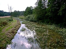
The municipality of Vollersode is located in the north German lowlands about 35 kilometers north of Bremen. The landscape of the place is shaped by the transition from the Wesermünder Geest to a glacial terminal moraine area into the Teufelsmoor . The districts Vollersode, Wallhöfen, Giehle and Giehlermühlen are located on the Geest at a height of 20 to 30 m above sea level. NN . The other districts are bog villages at a height of less than 5 m above sea level. NN. The Giehler Bach flows through the community as a small meadow river, which meets the Hamme-Oste Canal at Viehspecken and becomes the Hamme River .
Neighboring communities
In the south-west, Vollersode borders on Hambergen , in the north-west on Holste , both of which are also part of the Hambergen community. The community Gnarrenburg in the district of Rotenburg (Wümme) joins to the northeast . To the southeast lies the unified municipality of Worpswede , to the south the city of Osterholz-Scharmbeck .
Community structure
The municipality of Vollersode is divided into a total of nine districts:
- Ahrensdorf
- Born series
- Peace Home
- Giehle
- Giehlermoor
- Giehlermühlen
- Verlüßmoor
- Vollersode
- Wallhöfen
history
The community was first mentioned in 1185 as Valdersha . The name is explained by the coat of arms on which a fountain can be seen. Sode is another term for well, so Vollersode translates as Voller Brunnen . The bell-cup grave of Wallhöfen is located in a district of Vollersode on the Geest heights of the Teufelsmoor.
Incorporations
Vollersode formed in the course of the regional reform in 1974 with the communities Hambergen, Axstedt, Holste and Lübberstedt the joint community Hambergen.
politics
Municipal council
The council of the municipality of Vollersode consists of four councilors and nine councilors from the following parties:
(Status: local election on September 11, 2016)
Mayor
The mayor of Vollersode is Angela Greff (SPD). Your deputies are Günter Renken (SPD) and Arne Schnackenberg (CDU).
coat of arms
| Blazon : "In black reason, a silver wave bar and a Sodbrunnen with suspended bucket . The golden shield base is covered with black field stones . " | |
| Justification of the coat of arms: The basic colors black and gold reflect the moor and geest as the changing landscape of the municipality. The Sodbrunnen with attached bucket is a locally known landmark for the district Vollersode and at the foot of the coat of arms the black field stones symbolize the typical wall fencing of the older farmsteads in the district Wallhöfen that is still preserved today. The silver inclined wave stream establishes the connection to the Hamme. |
Culture and sights
Buildings
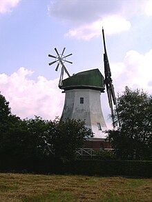
There is a Dutch windmill on the road from Wallhöfen to Bornzeile , which is now used as a residential building. In Giehlermühlen, directly on federal road 74, is the former grain water mill , whose mill jam , albeit without a wheel, is still there.
In the Wallhöfen district there is a 130 meter high telecommunication tower, a so-called type tower "FMT 2/73", which is operated by Deutsche Funkturm GmbH for Deutsche Telekom AG.
Nature reserves
At Giehlermühlen to the west of the main road is the Springmoor nature reserve , a Geest high moor with a low moor base.
Economy and Infrastructure
- traffic
There is a transport connection via the Lübberstedt and Oldenbüttel train stations , both around 10 km away, to the Bremen – Bremerhaven (- Cuxhaven ) line. The Autobahn 27 ( Walsrode –Cuxhaven) is 19 km away and can be reached via Landstrasse 134. The main traffic axis and connection to the district town of Osterholz-Scharmbeck and the regional center of Bremen is the federal highway 74 Bremen - Stade .
literature
- L. Behrens: The development of the Bornzeile bog colony . In: Men from the Morgenstern Heimatbund at the mouth of the Elbe and Weser. V. (Ed.): Niederdeutsches Heimatblatt . No. 2 . Nordwestdeutsche Zeitung, today Nordsee-Zeitung GmbH, Bremerhaven 1931, p. 1–2 ( digitized version [PDF; 4.2 MB ; accessed on October 13, 2018]).
Web links
Individual evidence
- ↑ State Office for Statistics Lower Saxony, LSN-Online regional database, Table 12411: Update of the population, as of December 31, 2019 ( help ).
- ↑ a b Municipal Council Vollersode. In: Website of the Samtgemeinde Hambergen. Retrieved October 13, 2018.
- ↑ Main statute of the municipality Vollersode. (PDF; 63.1 kB) In: Internet site for the Samtgemeinde Hambergen. March 8, 2012, p. 1 , accessed October 13, 2018 .


