
Oste-Hamme Canal
|
Oste-Hamme Canal Hamme-Oste Canal |
||
 The course of the Oste-Hamme Canal |
||
| Data | ||
| Water code | DE : 59836 | |
| location | Lower Saxony , Germany | |
| River system | Oste | |
| Drain over | Oste → Hamme → Weser | |
| Source height | about 7 m above sea level NHN | |
| muzzle | In Spreckens in the Oste . In Karlshöfen / Kreuzkuhle in the Kollbeck. Coordinates: 53 ° 26 ′ 55 " N , 9 ° 7 ′ 7" E 53 ° 26 ′ 55 " N , 9 ° 7 ′ 7" E |
|
| Mouth height | about 6 m above sea level NHN | |
| Height difference | about 1 m | |
| Bottom slope | about 0.05 ‰ | |
| length | about 19 km | |
| Catchment area | 19.94 km² | |
| Left tributaries | Brick canal, hut canal. | |
| Right tributaries | Ostegraben Oberbarkhauser Canal Försterkanal (near Barkhausen) Augustendorfer Canal |
|
| Small towns | Spreckens , Fahrendorf , Klenkendorf , Findorf , Ostersode , Langenhausen, Barkhausen. | |
| Communities | Unified community Gnarrenburg. | |
| Ports | Torfschiffhafen at the Kreuzkuhle. | |
| Navigable | From the source to the estuary, a water hike is possible through dams . | |
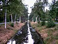
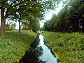
The Oste-Hamme Canal or Hamme-Oste Canal is a canal in northern Germany that connects the Oste with the Hamme . It goes from the Oste at Spreckens four kilometers above Bremervörde and runs through the former Teufelsmoor and Gnarrenburg until it reaches the Hamme at Viehspecken. The area of the canal near the confluence with the Hamme is also called Kollbeck .
history
The canal was built by Jürgen Christian Findorff from 1769 to 1790 and was used to drain the Teufelsmoors and to carry freight (mainly peat towards Bremen and Hamburg ) with peat barges. These peat barges were called half-hunt barges or ships. About six cubic meters of peat could be transported on these half-hunt barges. The long construction period was due to the difficulties caused by the soft peat soil, which kept slipping and made it necessary to dig again. Construction was particularly difficult in the village of Langenhausen because a sand dune protrudes from the moor in the middle of the village. From the 1860s onwards, numerous folding ropes and double locks were installed, which made peat navigation easier.
environment
flora
The canal has several barrages and a steep, high embankment with trees on the upper edge. In the area of Klenkendorf, the bank is partly fixed with fascines made of black plastic sheets. In the Spreckens area, fascines are only installed near bridges and barrages. The river sediment is peaty and there are some dense deposits of detritus . In Langenhausen in particular, the sediment consists increasingly of digested sludge.
fauna
There are no significant fish stocks in the Oste-Hamme Canal. However, water rats and ducks are typical .
Water quality
The biological water quality investigation and the chemical-physical water analysis were carried out in 1997. The Oste-Hamme Canal was classified in water quality class III (tendency to III – IV “very heavily polluted”). There are high concentrations of ammonium and orthophosphate pollution in the water . The cause of the phosphate concentration is raised bog drainage and the agricultural use of the bog soil. The exposure to coliforms was increased several times.
Importance as a traffic route
The canal initially formed the only inland waterway between the Elbe and Weser . It is 19 km long, had a bottom width of four meters and a water level width of six meters. The water depth was 0.9 meters. Today the canal is overgrown and no longer navigable. By repairing the folding ropes, water hikes are possible at best.
gallery

Oste-Hamme Canal in Spreckens with folding jam

Information board in Klenkendorf
The Oste-Hamme Canal near Findorf

Klappstau on the Oste-Hamme Canal near Findorf
The Oste-Hamme Canal near Spreckens

It flows into the Oste in Spreckens


