
Hamme (river)
|
Hamme Hamm (Low German) |
||
 Run from Giehler Bach and Hamme from Langer Heide into Teufelsmoor to the mouth in Lesum |
||
| Data | ||
| Water code | EN : 4948 | |
| location | Lower Saxony , Germany | |
| River system | Weser | |
| Drain over | Lesum → Weser → North Sea | |
| source | Lange Heide ( Giehler Bach ) 53 ° 15 ′ 5 ″ N , 8 ° 45 ′ 9 ″ E |
|
| Source height | 45 m above sea level NN | |
| muzzle | Joins at Ritterhude with the Wümme to form Lesum Coordinates: 53 ° 10 ′ 22 ″ N , 8 ° 44 ′ 40 ″ E 53 ° 10 ′ 22 ″ N , 8 ° 44 ′ 40 ″ E |
|
| Mouth height | 2 m above sea level NN | |
| Height difference | 43 m | |
| Bottom slope | 0.89 ‰ | |
| length | 48.5 km | |
| Catchment area | 549 km² | |
| Discharge at the mouth of the A Eo : 549 km² |
MQ Mq |
4.5 m³ / s 8.2 l / (s km²) |
| Left tributaries | Schaufleet, Kollbeck, Rummeldeisbeek, Schmoo, Neu Sankt Jürgener Schiffgraben, Umbeck, Wörpedahler Graben, Semkenfahrt, Kirchenfleet, Neugrabenfleet, Deichkampfleet | |
| Right tributaries | Butterweidengraben, Beek , Fankstaken, Osterholzer Hafenkanal , Scharmbecker Bach , Ritterhuder Beeke | |
| Small towns | Osterholz-Scharmbeck | |
| Communities | Hambergen , Lübberstedt , Vollersode , Gnarrenburg , Worpswede , Ritterhude | |
| Ports | Osterholz-Scharmbeck , Worpswede , Gnarrenburg | |
| Navigable | From the transition from the Oste-Hamme Canal to the Kollbeck (where the kilometrage begins) to the confluence with the Lesum . The locks and the applicable nature conservation regulations are the main limiting factors. | |
The Hamme (Low German: Hamm) is the 48 km (of which approx. 27.5 km are navigable, from the end of the Oste-Hamme Canal ) long, right or northern source river of the Lesum , a right tributary of the Weser in Lower Saxony and Bremen . The Hamme catchment area is located directly northeast of the city of Bremen in the Elbe-Weser triangle .
The Hamme drains the Teufelsmoor between Worpswede and the district town of Osterholz-Scharmbeck . The Hamme-Oste Canal forms the north-eastern continuation of the Hamme upstream; the canal connects the river with the Oste , which the former meets at Bremervörde . At Ritterhude downstream the Hamme joins the Wümme, which is considerably more watery (on average 15.5 m³ / s compared to 4.5 m³ / s in the Hamme) to form the Lesum.
River course
The upper reaches of the Hamme is called Giehler Bach and rises in the Lange Heide northeast of Osterholz-Scharmbeck. The designated "source" carries the water of several drainage ditches of the now agriculturally used, about 45 m above sea level. NN high Geest plateaus . This terminal moraine of the Saale Ice Age is also the headwaters of other Geestrand brooks such as Drepte , Scharmbecker Bach , Schönebecker Aue and Wienbeck .
First of all, the Giehler Bach flows to the northeast and sinks between the villages of Hülseberg and Freißenbüttel within a few kilometers to a level of around 15 meters above sea level. NN. At Ohlenstedt , water flows in from the Ohlenstedter spring lakes , and the river crosses the municipality of Hambergen with a slight gradient to the spring moor near Giehlermühlen ( Vollersode ) (5 m above sea level).
From there the river sinks only minimally to the Teufelsmoor and finally becomes a Hamme in the Giehler Moor near Viehspecken (4 m above sea level) . The former Kollbeck brook, which was expanded to form the Hamme-Oste Canal, also flows here . With an extremely low current, the Hamme flows south from Viehspecken through the glacial valley named after it .
Between the former peat Bornreihe and Hüttenbusch therethrough continue towards Worpswede where the three left inflows Rummeldeisbeek , Schmoo and Umbeck open. A few kilometers downriver, the Beek flows from the right and drains most of the moorland west of the Hamme. From the mouth of the Beek, the Hamme flows in a south-westerly direction past Osterholz-Scharmbeck towards Ritterhude .
This part of the Hamme was straightened as early as the 19th century, and the numerous meanders were pierced in a total of seven places, so that the course of the river on this route was shortened from 9 km to 4.3 km. Most of the oxbow lakes remained as one-sided confluences with the Hamme. A remaining part of the so-called Altarm 3 southeast of Scharmbeckstotel was desludged in 2007 as part of the Hammeniederung nature conservation project and in 2008 a bed sill was inserted to prevent it from running dry at low water. At the end of January 2020, after a construction period of three months, the 230 m section of this arm, which had been filled in, was dug up again over a length of 230 m and connected to the Hamme.
Behind the built in 1876 lock in Ritterhude by which the Hamme tide freely held, the Hamme strikes near the city limits of Bremen on the Wümme and forms with her from brackish water influenced Tidefluss Lesum , 10 km below the Weser flows.

Upper course of the Hamme (Giehler Bach) in the spring moor

The mouth of the Giehler Bach and the Oste-Hamme Canal at Viehspecken

Hamme at the peat harbor New Heligoland
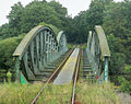
Railway bridge of the Moorexpress over the Hamme between Weyermoor and Melchers Hütte

Pedestrian bridge over the Hamme at Melchers Hütte

the river from above at Ritterhude
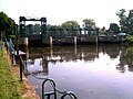
Hammeschleuse in Ritterhude
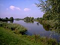
The confluence of the Hamme and the Wümme (from left) to the Lesum


Locks & lifting bridges
At the Hamme there are a total of three locks in Hartheckel, Teufelsmoor and Ritterhude.
Hartheckel self-service lock
The Hartheckel self-service lock is 4.2 km away and is 10.80 m long and 2.75 m wide. It was built in 1961 as part of the expansion to replace the previous locks Viehspecken and Hartheckel.
Teufelsmoor self-service lock & Teufelsmoor lift bridge
The Teufelsmoor self-service lock is located at a river kilometer 9.5 km and is 17.60 m long and 6.50 m wide. It was built in 1959 as part of the expansion to replace the former Teufelmoor lock. It has a lift bridge that is only opened if you register with the GLV Teufelsmoor in advance.
Lift bridge New Heligoland
The lift bridge will only be opened if you register in advance with the municipality of Worpswede .
Ritterhude
The Ritterhude lock is 25.3 km away and is 26.00 m long and 6.30 m wide. It was built in 1874/1875 and forms the border to the tide-dependent lower course of the river. The lock is carried out by a lock keeper.
use

The Hamme is still used to drain the moorland between Worpswede and Osterholz-Scharmbeck. It was also used to remove peat with the help of peat barges . In its opening year, the Ritterhuder lock was passed by 8,994 peat barges, 65 buck ships and 81 barges, in autumn by up to 500 units a day. Between the Teufelsmoor settlement and the beginning of the Osterholz port canal, seven hammers were built in the 19th century at Holtstellen. At these points, peat could be loaded onto block ships. There was also a bar in the huts. Today there are still three Hammehütten, namely Neu-Helgoland, Melchers Hütte and Tietjens Hütte.
At the beginning of the 1980s, the first replicas of historical peat barges were made in the Teufelsmoor region and discovered for tourism a little later. Peat barge trips are usually offered from May to September.
Today the Hamme is mainly used for tourism and leisure, both by neighboring clubs and individuals. In addition to the Alma passenger ship and the peat barges, there are also smaller motor boats, canoes, SUPs and rowing boats. This use is restricted by the applicable nature conservation and landscape protection regulations (more on this in the section on traffic regulations).
Access regulations
Today, due to the collective ordinance for nature and landscape protection areas in the area of Hammeniederung and “Teufelsmoor”, which came into force on April 20, 2017, as well as their 1st amendment ordinance of October 3, 2019, strict navigation regulations for motorized and non-motorized water sports apply to the Hamme.
The regulations for boat traffic on the Hamme aim to avoid impairment of the aquatic ecosystems, u. a. the avoidance of disturbances to breeding and resting birds as well as the otter.
Motorized water sports
All information is provided without any guarantee of absolute correctness; the respective ordinance should be read before driving on it.
All motorized boats over 12 m in length are generally prohibited, with the exception of the Alma passenger ship and the peat barges.
Viehspecken - Teufelsmoorstraße L153
The section between Viehspecken and Teufelsmoorstrasse may only be used by peat barges, max. 10 boats of the WSV Viehspecken, as well as max. 5 guest boats of the association can be used and other boats with permanent berths at the Viehspecken campsite. In addition, for max. 10 boats at the same time limited special permits are granted. In the period from November 1st to March 31st inclusive, there is a winter driving ban. There is also a night driving ban between 11:00 p.m. and 6:00 a.m.
Teufelsmoorstraße L153 - New Helgoland lift bridge
The section between Teufelsmoorstraße L153 and the lift bridge at Neu Helgoland may only be used by peat barges, max. 10 boats of the WSV Viehspecken, as well as max. 5 guest boats of the association can be used and other boats with permanent berths at the Teufelsmoor and Viehspecken campsites or in the Neu Helgoland leisure harbor. In addition, for max. 10 boats at the same time limited special permits are granted. In the period from November 1st to March 31st inclusive, there is a winter driving ban. There is also a night driving ban between 11:00 p.m. and 6:00 a.m.
Lift bridge Neu Helgoland - bridge K9 at Tietjen's hut
The section between the lift bridge Neu Helgoland and the bridge of the K9 at Tietjen's Hütte may only be used by the passenger ship Alma, Torfkähnen, max. 25 boats of the WSV Ritterhude, max. 30 ESV Bremen boats, max. 35 boats of the Ritterhuder Uhlen association, max. 45 boats of the SC Hamme, max. 30 boats from WSG Worpswede, max. 10 boats of the WSV Viehspecken, as well as max. 5 guest boats per club and other boats with permanent berths at the Teufelsmoor and Viehspecken campsites, as well as other legally established moorings. In the period from November 1st to March 31st inclusive, there is a winter driving ban. There is also a night driving ban between 11:00 p.m. and 6:00 a.m.
Bridge K9 at Tietjen's hut to Ritterhuder lock
The section between the bridge of the K9 at Tietjen's Hütte and the Ritterhuder lock may be used by all motorized boats that meet the length restriction. There is no winter or night driving ban on this section. The port of Osterholz-Scharmbeck is therefore always available.
Non-motorized water sports
All information is provided without any guarantee of absolute correctness; the respective ordinance should be read before driving on it.
Viehspecken to the Neu Helgoland lift bridge
The section between Viehspecken and the Neu Helgoland lift bridge can be used all year round by non-motorized boats. There is a night driving ban from 11:00 p.m. to 6:00 a.m. Driving with SUPs is prohibited.
Lift bridge Neu Helgoland to Melcher's Hut
The section between the Neu Helgoland lift bridge and Melcher's Hütte may be used by non-motorized boats between April 1st and October 31st, as there is a winter driving ban, and there is also a night driving ban between 11:00 p.m. and 6:00 a.m. Driving with SUPs is prohibited.
Melcher's Hut to bridge K9 at Tietjen's Hut
The section between Melcher's Hütte and the bridge of the K9 at Tietjen's Hütte can be used all year round by non-motorized boats. There is a night driving ban from 11:00 p.m. to 6:00 a.m. Driving with SUPs is prohibited.
Bridge K9 at Tietjen's hut to Ritterhuder lock
The section between Melcher's Hütte and the bridge of the K9 at Tietjen's Hütte can be used all year round by non-motorized boats. Driving with SUPs is allowed here.
Nature and landscape protection
The Hamme forms the center of the Hammeniederung , a large biotope network in the Elbe-Weser triangle.
literature
- Hans Siewert : Hammer ride. In-depth observations and interesting experiences on a peat boat trip from Osterholz harbor via “Tietjens Hütte” to “Neu-Helgoland”. Simmering, Lilienthal 2010.
Web links
Individual evidence
- ^ Dieter Coldewey: Wümme area forum. Results of the surface water inventory (PDF; 3.9 MB) (accessed on August 21, 2013)
- ^ Franzius Institute (University of Hanover): Wümme flood protection plan. (pdf; 7.52 MB) Report No. 685. 2006, p. 276 , accessed on August 10, 2013 .
- ↑ Note: Application of an area discharge of approx. 8.2 l / s km² (averaged from the data of the surrounding gauges Hellwege an der Wümme, Ahrensdorf am Giehler Bach (Hamme-Oberlauf) and Oberlethe an der Lethe) on the catchment area of the Hamme
- ↑ DRV: https://gewaesser.rudern.de/hamme
- ^ Osterholzer Anzeiger: The old arm of the Hamme was restored from March 8, 2020; P. 9
- ↑ DRV: https://gewaesser.rudern.de/hamme
- ↑ GLV Teufelsmoor: https://www.glv-teufelsmoor.de/verbandsstruktur/andere_bauwerke/hartheckel
- ↑ DRV: https://gewaesser.rudern.de/hamme
- ↑ GLV Teufelsmoor: https://www.glv-teufelsmoor.de/verbandsstruktur/andere_bauwerke/teufelsmoor
- ↑ DRV: https://gewaesser.rudern.de/hamme
- ↑ GLV Teufelsmoor: https://glv-teufelsmoor.de/service/schleusenzeiten
- ↑ GLV Teufelsmoor: https://www.glv-teufelsmoor.de/storage/pdf/SchleuseRitterhude_Steckbrief.pdf
- ^ Jürgen Heuser: Peat barge . July 2, 2010
- ^ Torfkahnschiffer Osterholz-Scharmbeck eV: Hammehütten
- ↑ District of Osterholz: large-scale nature conservation project of nationwide representative significance "Hammeniederung". Final report 2012 . May 2012, p. 63 (PDF file, 16.1 MB)
- ↑ District of Osterholz: https://www.landkreis-osterholz.de/portal/seiten/sammelverordnung-901001663-21000.html
- ↑ District of Osterholz: https://www.landkreis-osterholz.de/portal/seiten/sammelverordnung-901001663-21000.html
- ↑ District of Osterholz: https://www.landkreis-osterholz.de/portal/seiten/sammelverordnung-901001663-21000.html
- ↑ District of Osterholz: https://www.landkreis-osterholz.de/portal/seiten/sammelverordnung-901001663-21000.html
- ↑ District of Osterholz: https://www.landkreis-osterholz.de/portal/seiten/sammelverordnung-901001663-21000.html
- ↑ District of Osterholz: https://www.landkreis-osterholz.de/portal/seiten/sammelverordnung-901001663-21000.html
- ↑ District of Osterholz: https://www.landkreis-osterholz.de/portal/seiten/sammelverordnung-901001663-21000.html
- ↑ District of Osterholz: https://www.landkreis-osterholz.de/portal/seiten/sammelverordnung-901001663-21000.html
- ↑ District of Osterholz: https://www.landkreis-osterholz.de/portal/seiten/sammelverordnung-901001663-21000.html