
Oste
| Oste | ||
 Course of the Oste in the Elbe-Weser triangle |
||
| Data | ||
| Water code | EN : 598 | |
| location | Counties Harburg , Rotenburg , Stade and Cuxhaven ; Lower Saxony ( Germany ) | |
| River system | Elbe | |
| Drain over | Elbe → North Sea | |
| River basin district | Elbe | |
| source | at Otter near the Otterberg 53 ° 15 ′ 12 ″ N , 9 ° 43 ′ 49 ″ E |
|
| Source height | approx. 61 m above sea level NHN | |
| muzzle | between Belum and Balje in the same - estuary coordinates: 53 ° 50 '21 " N , 9 ° 0' 54" O 53 ° 50 '21 " N , 9 ° 0' 54" O |
|
| Mouth height | 0 m above sea level NHN | |
| Height difference | approx. 61 m | |
| Bottom slope | approx. 0.41 ‰ | |
| length | 149.4 km | |
| Catchment area | 1,714.69 km² | |
| Discharge at the Rockstedt A Eo gauge : 611 km² Location: 97.8 km above the mouth |
NNQ (23 August 1976) MNQ 1961–2014 MQ 1961–2014 Mq 1961–2014 MHQ 1961–2014 HHQ (22 January 2008) |
880 l / s 1.85 m³ / s 6.3 m³ / s 10.3 l / (s km²) 39.1 m³ / s 113 m³ / s |
| Discharge at the mouth of the A Eo : 1,714.69 km² |
MQ Mq |
17.7 m³ / s 10.3 l / (s km²) |
| Left tributaries | Mehde-Aue , Bade , Mehe , Aue | |
| Right tributaries | Ramme , Twiste , Bever | |
| Small towns | Bremervörde , Hemmoor | |
| Navigable | From the estuary to the east for inland waterways and on to Bremervörde for smaller ships. |
|

The Oste [ ˈoːstə ] (on the upper reaches to Sittensen also ˈɔstə ) is the longest left tributary of the Lower Elbe in Lower Saxony with 149.4 km . It flows through the districts of Harburg , Rotenburg , Stade and Cuxhaven and has a catchment area of almost 1000 square kilometers near Bremervörde, which increases to 1714.69 km² up to the mouth. The section from Bremervörde to the mouth is about 75 km long.
Until June 30, 2010, the Oste was a zone 2 federal waterway from the mill weir in Bremervörde to the mouth of the Elbe. Since July 1, 2010, only the section 210 meters above the axis of the road bridge over the eastern barrier (km 69.360) to the eastern estuary is a federal waterway of waterway class IV . The Cuxhaven Waterways and Shipping Office is responsible for this. On the Oste, the shipping route regulations apply . The Oste has been new kilometers since 1996.
geography
course
overview
The Oste rises in the Harburg district near Otter . From there it flows as a quiet meadow river in its upper reaches first west, then northeast past Zeven and further north through Bremervörde in the district of Rotenburg, from where it can be used by smaller ships . From Bremervörde ebb and flow also have an effect . The southern and western limits of the river's course are formed by terminal moraine lines from earlier glacial periods , the most prominent section of which is the Wingst .
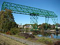
At Bremervörde there is a barrage and a small harbor , so that the Oste can be navigated from there with small boats and ships with a draft of up to 2 m after medium high tide. Then meanders of now of dikes bordered river further north in the direction of places Hemmoor and East ; The oldest German transporter bridge, the Ost-Hemmoor transporter bridge, is located at this location . The road leading over the Oste at this point is particularly important for crossing the Elbe on the ferry connection between Wischhafen and Glückstadt. The river flows on the border of the municipalities Belum in Cuxhaven and Balje in the district Stade in the same - estuary (estuary).

Upper East


The sources of the Oste are located near Schillingsbostel in the municipality of Otter, a little south of the center of the municipality of Tostedt . To the south the landscape rises to the Otterberg ( 101 m ), which belongs to the Zevener Geest . A few kilometers to the east is the northwestern edge of the Lüneburg Heath and southwest of the Wümmeniederung .
Initially, the Oste flows through a low moor area close to the source with alluvial forest as well as ponds and ponds as a quiet meadow river westward past Tiefenbruch and sources and through the south of the municipalities of Wistedt and Heidenau and through the northern municipality of Tiste . It then crosses the village of Sittensen , where, as in Eitzmühlen, there is a well-preserved mill from the Middle Ages on its bank. In the west of Sittensen, on the border with the community of Groß Meckelsen , the Ramme flows out on the right . The Oste then forms the border between the communities of Groß Meckelsen and Hamersen or Elsdorf for some time . The river then enters the community of Heeslingen and flows between the towns of Freyersen and Weertzen and through the center of Heeslingen. In Offensen the river leaves the community again and touches the to Zeven belonging Brauel . Between the mouth of the Twist and Ostereistedt, the Oste changes its direction of flow from west to north. The Oste flows along Godenstedt in the community of Seedorf , where the bathing area on the left and the Twiste on the right in the village . In the municipality of Selsingen be Eitzte and Lavenstedt happens. The Oste now forms a municipal boundary again, this time between Selsingen and Ostereistedt , where Rockstedt is near the Oste. The river now turns more and more to the north in a gentle curve, enters the municipality of Sandbostel and touches Ober-Ochtenhausen and Sandbostel. Minstedt , which belongs to Bremervörde, is the next station on the river, which now passes Spreckens and Engeo , where, four kilometers above Bremervörde, on the left-hand side to the southwest, the Oste-Hamme Canal goes through the Teufelsmoor towards Hamme von der Oste, as does the Fahrendorfer Canal shortly afterwards . Shortly before Bremervörde, the Bever flows into the Oste on the right, which then enters the city of Bremervörde.
Unteroste from Bremervörde


In Bremervörde there is a small river island, which is formed by a side arm that has been expanded into the main arm since 1950. The river then flows past the Vörder See . Opposite was the Gnattenberg shipyard , which Ewer built and repaired.
Shortly after Bremervörde, the Oste-Schwinge Canal goes off on the right , which connects the Oste with the Schwinge shortly after its source at Mulsum . From Nieder Ochtenhausen and Elm, it forms the border of the rural districts of Rotenburg ( Ostendorf ) and Stade with interruptions in Graepel and Brobergen , where the Stade district also extends to the left-hand side. In Brobergen the last motorized prahmferry, the Ostefähre Brobergen, is operated. This is also the intersection of various cycle paths. The confluence of the Mehe and the three-district-corner to the district of Cuxhaven, whose border with the district of Stade now forms the Oste over a long distance, is also located here on the left . The Oste now touches the Nindorf area and flows past Laumühlen , the Geesthof , Klint as well as Kranenburg , Blumenthal and Kleinwörden . At Burweg and Hechthausen it is crossed by the railway bridge of the Unterelbe Railway from Hamburg-Harburg to Cuxhaven and the federal highway 73 . The Rönne flows into it at Großenwörden .
Lower east from the east
In the east the oldest German driving Transporter Bridge ( 1909 completed) and sets by Basbeck , a district of Hemmoor over. In Osten, Hemmoor and Oberndorf , both banks now belong to the district of Cuxhaven. After Hemmoor, the Oste passes the Wingst ridge . At the height of Neuhaus (Oste) the estuary of the Oste begins to open to the north into the Lower Elbe .
With the farmsteads Mühlenwisch and Altenwisch , the district of Stade touches the Oste again a few kilometers before the estuary. These two farms (belonging to Balje) are separated by the Geversdorf district of Itzwörden in the district of Cuxhaven . Here the ferry connection of the Ostefähre Geversdorf , which had existed since 1423, was replaced by a bascule bridge in 1988.
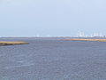
About 2.7 km north-northwest of the eastern barrier , the Oste flows into the large Elbe with a width of around 800 m between the hamlet Belumer Deich von Belum in the nature reserve Hadelner and Belumer Außenendeich in the west and the district of Hörne von Balje with the Ostebrammer Hullen in the east - Estuary. The estuary with the Ostebank (Osteriff) upstream in the Elbe estuary is in the Hullen bird sanctuary .

Geversdorf, 1988 built bascule bridge over the Oste

The Oste between Neuhaus (Oste) and Balje

The last meters of the Oste
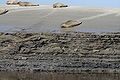
Seals are regular guests in the Eastern Estuary

The old estuary
The new estuary, in winter when the weather is calm


Soils and Terrain
The upper reaches of the Oste lies on the Geest . At Sandbostel and Granstedt , for example, there are also inland dunes with drifting sand drifting as high as a house. From Gräpel , the subsoil consists of real marshy soil . After the last ice age, the river had formed its own glacial valley .
Tributaries and canal connections
The following table starts with the first river or ditch that flows into the Oste and ends with the last. In addition to the estuaries, canal connections are also listed.
|
|
|
|
Localities

Morals

Bremervörde
east
Hemmoor

Neuhaus (Oste)


There are numerous important cities and towns along the Oste. Here Tostedt near the springs, Heeslingen and Sittensen should be mentioned on the Upper East . From the lower east near Bremervörde , this includes Hechthausen , east with the transporter ferry , Hemmoor and Neuhaus .
history
The Oste probably got its name before 1000 BC. Chr . receive. It should consist of a form of the Indo-European stem that before formation of the common Germanic was, and joins numerous similar forms such as in Osna at bridging the various extensions of a river , stream , water characteristic word from * are. The exact meaning of the word with ablaut on -t- cannot be reconstructed. In the Middle Ages, the name Ostinggabi (Ostegau) for an area in the area of the river resulted from Oste .
For a long time, there was the last fixed crossing of the river before the mouth, 74 km away, in Bremervörde, where a ford could first be used (Vörde is a Low German form of ford) and soon a bridge was also built. There was also a water mill here. The bishops of Bremen resided in the Bremervörde Castle for a long time , which means that shipping there was quite large. After the Peace of Westphalia and the end of the diocese, shipping increasingly shifted to the lower reaches.
Bremervörde was an important point on the route from Hamburg to Bremen, at which both the Oste could be easily crossed and a Geestrücken made it possible to cross the moors that lay south (Teufelsmoor) and north. Therefore, one began to collect road tolls in Bremervörde early on. This practice was not abandoned until 1825.
Shipping traffic on the Oste was first reported around 1250, when many Ewer were already sailing the river.
In 1690 Johann Ernst Rist reported that dyke breaches led to the silting and silting of the Oste, which hindered shipping off Bremervörde and reduced the number of sturgeon and salmon in large numbers.
The first river regulation was carried out in 1759–1764 on the approximately 6 km long stretch from Bremervörde downstream. Between 1808 and 1882 a total of 239 groynes were built as part of major regulatory work. Most of the banks remained unpaved.
The first major intervention in the course of the river took place in 1928, when the mouth of the largest tributary of the Elbe was moved further west towards Cuxhaven.
Shipping on the Oste reached its peak at the beginning of the 20th century, when almost all goods to be transported in large quantities were moved with countless Ewers. In the course of the century, however, this traffic steadily decreased, as technical progress and better infrastructure made other modes of transport such as road and rail more economical. In the end there was only little movement of goods with the Hemmoor cement works. Between Bremervörde and Hechthausen the only goods still had three to four fertilizer transports annually after Gräpel that took place until the 1980s. This traffic finally came to a standstill in the 1990s.
Cement plant in Hemmoor

The Portland cement plant was built in Hemmoor around 1864 and loaded its products onto ships in Schwarzenhütten. Schwarzenhütten was previously the landing stage of a brick factory. The cement factory acquired it and expanded it into the largest port on the Oste. In 1875 a horse-drawn tram was built from the plant at today's Hemmoorer Kreidesee to the pier , which was upgraded with steam locomotives in 1895. The cement was with barges and barges brought to Hamburg to ship it from there. On the way back, coal was transported for the factory. At its peak in the 1960s, almost 500,000 tons were handled. Schwarzenhütten continued to operate after the end of the factory in 1980 and mainly handled fertilizers and coal, but finally ceased operations on December 22, 1997.
whaling
In 1766, the merchant Johann Thumann from Geversdorf drove the acquisition and equipment of a whale catcher called "Ost Strom" (in the sources from this time also called "Ost Stroom", "Der Osten Strohm" or "Der Oste Strom"), the one in front of Greenland was supposed to hunt and was stationed in Geversdorf. He delivered the whale bacon to Hamburg to be boiled. A joint-stock company was founded in which a number of merchants and richer march farmers were involved. Thumann became its managing director. The annual fishing trips under a total of three different commanders were very uneven. While they returned with 7¼ “fish” in 1768, not a single one was caught in 1775. Due to constant quarrels with Thumann, who appears in the sources as an unpleasant business partner, and possibly due to insufficient profits, operations were stopped after the trip in 1777.
Between 1767 and 1777 the ship is said to have caught 37 7/12 whales and brought in 1,336½ quardeles of tran and 17,310 pounds of beards . A quardeel is 3 tons of 200 to 226 pounds each, so the total was at least 801,900 pounds.
Further whaling operations from the Oste were planned. The equipment of a whaler by the Neuhausen merchants Ahrens and Ulex failed in 1788, but in 1799 a company was founded in Osten, which in 1800 sent a ship with a crew of 40 to Greenland and returned successfully. But because of the Napoleonic turmoil, this one trip remained.

In 1814 Johann Thumann junior planned another trip to Greenland with two ships. It is not known whether this took place. In 1816 the brig “The Friendship” went on a Greenland voyage, which was a business failure. The Thumann family had got into financial difficulties, but Johann Thumann tried to fight his way financially by re-equipping the ship. From 1819 to 1821 she made three more trips, all of which had a depressing result. Thumann and some of the company's shareholders were now finally bankrupt.
Before 1800 there was a oil distillery in Geversdorf.
The Eastern Barrier

After the storm surge in 1962, it was decided to build the eastern barrier . In addition to the actual Oste, a part of the village Baljes , a canal and the barrage were built near Neuhaus in 1968 between the Belumer Deich in the west of the Oste and Hörne, and later the Oste was diverted there. The barrage consists of five passages, each 22 m wide. The outer openings can be closed by segment flood gates. In the middle, the ship passage consists of two pairs of mitred gates. There is also a bridge to defend the dike. The height up to which the barrage is safe is 7.80 m, which no longer corresponds to the height of the new Elbe dyke at around 8.40 m. The dikes of the Oste have a height of 5.30 m to 5.90 m.
There has been no damage from storm surges since the barrage went into operation. The floods of 1972 and 1999 had no consequences for the Eastern area.
Natureum Niederelbe

The old arm of the Oste, which was dammed from the river by the construction of the barrage and the relocation of the dike line, is now the so-called ' Ostesee ' with a leisure facility (water skiing facility, sandy beach, etc.). The Lower Elbe Natureum was built on the island, which was artificially raised by flushing . It provides information about the fauna and flora of the North Sea coast on more than 60,000 m² of open space and in several buildings. There is also a fishing cutter from 1892 on the open-air site. The "Erna Becker" was built in Cranz as a sailor and fished with two large hats (rectangular frames) that keep the sack-shaped nets open in the area of the Lower Elbe and the Oste between Kleinwörden and Sethlerhemm.
Flora and fauna


The Oste, which is the longest river between the Weser and Elbe, is of great ecological importance as it has not been straightened and, for the most part, has a natural bank. For example, the estuary with its natural tidal range is part of the Wadden Sea . With a water quality of level II (moderately polluted), the Oste is consistently relatively clean, although some tributaries bring water of quality class III (heavily polluted) and even III-IV (very heavily polluted). The river is very rich in fish and is considered to be the first German river with a self-rejuvenating salmon population .
The sturgeon, like salmon, used to be native to the Oste and was even the most common fish of all - so numerous that it is said that the service staff were indignant and demanded to ensure that there were no more sturgeons to eat than twice a week (Something similar has been handed down from other areas, so that one cannot assume that this protest is a historical fact). Today the fish is believed to be extinct or almost extinct. In the last few decades there have only been isolated reports of sightings. The Lamstedter Angling Association tries to breed these fish species with the help of imported eggs and by capturing spawning females for breeding and subsequent release.
Instead, the most common fish today is the smelt .
Other fish that occur are beak , eel , carp , pike , bream , stickleback and river lamprey , allis shad , feint and pikeperch . The banks are mostly from Reet marked zones.
Close to the Lower Elbe Natureum, more precisely on the sandbanks in the Ostewatt, these animals are increasingly to be found again at the Rammelbucht after the great seal deaths. Since anchoring is not explicitly forbidden at this point, the seals and breeding birds in the vicinity are frequently disturbed by pleasure boats.
use


The Oste is rarely used by professional boaters. One of the exceptions was a port fisherman .
- River kilometer 0.0: northeast edge of the Bremervörde mill weir
- River kilometer 0.5: slipway, meandering area, Bremervörder yacht club,
- River kilometer 12.2: near the village of Graepel, a privately operated hand-pulled cable ferry
- River kilometer 17.6: Voluntarily operated commercial ferry for the farmers and also as a public connection with regular, seasonally dependent ferry times, motorized cable ferry of the Brobergen ferry company.
- River kilometer 23.4: slipway, jetty of the holiday park Geesthof
- River kilometer 24.3: Kranenburg jetty
- River kilometer 29.8: the railway bridge (Stade – Cuxhaven)
- River kilometer 30.7: road bridge of the B73
- River kilometer 31.0: Hechthausen jetty
- River kilometer 38.0: Grossenwörden jetty
- River km 47.6: transporter bridge to the east
- River km 47.9: road bridge and jetty east
- River kilometer 49.8: “Schwarzenhütten” unloading and loading area with crane, for seagoing ships with a draft of 4.5 m and a length of up to 85 m, no recreational craft docks.
- River kilometer 55.4: jetty community Oberndorf
- River kilometer 55.6: Oberndorf bascule bridge
- River kilometer 64.2: Boat pier Seglervereinigung Oste in Geversdorf
- River kilometer 64.4: Geversdorf bascule bridge
- River kilometer 67.7: jetty and harbor with slipway (flood only) community Neuhaus
- River kilometer 69.5: storm surge barrier and barrage bascule bridge Balje
- River kilometer 74.6: confluence with the Elbe-km 707
tourism
The Oste and the adjacent Wadden Sea are navigated by the Mocambo , the oldest motor-driven passenger ship in Germany, with which excursions and ecological excursions are organized.
water sports
When the water level is good, the Oste is navigable from Burgsittensen , otherwise from Sittensen or Weertzen to the mouth with kayaks and canoes . The upper reaches from Sittensen to Volkensen are closed from March 1st to July 15th. Motorboats can also be used on the Oste below Bremervörde . In contrast to the upper course, the lower course is largely diked. It is subject to the effects of ebb and flow.
There is a water ski facility near the eastern barrier at Neuhaus . There is also the Natureum Niederelbe , which deals with life and nature in the border area between the sea and the river. There are motor and sailing boat clubs in Elm and Bremervörde. Kayaks and canoes can be rented in Graepel, at Geesthof and in Hechthausen an der Mühle.
Due to the large fish population and its special beauty, the Oste is a paradise for anglers and water hikers, so that the Oste is not only visited by anglers in summer and is used by recreational canoeists. Many people come from Hamburg or Bremen to do this . Failure to observe closed times and driving bans can damage the flora and fauna in the upper reaches , for example by impairing the vegetation on the banks and the habitat of the kingfishers .
In addition to the numerous Oste exist along the course of lakes that were created during the construction of dikes and are mostly used as fishing ponds or lakes.
River of ferries


Since May 2004, the Oste has been part of the Deutsche Fährstrasse , an approximately 250-kilometer holiday route that connects Kiel and Bremervörde and whose landmarks are the last two German suspension ferries across the Oste and the Kiel Canal .
Up until the 20th century, more than two dozen ferries operated on the “river of ferries”, most of which have now been replaced by bascule bridges (as in Geversdorf and Oberndorf ) or (as in Hemmoor and Hechthausen ) by fixed bridges.
Prahm ferries are - apart from a cattle ferry in Schönau (belongs to Gräpel) - only in operation in Brobergen and Gräpel ; the one in Graepel is one of the last in Germany that is still hand-drawn. Each of the two ferry stations also has an inn, which is operated in personal union with the ferryman. In addition to agricultural traffic, which is their actual business purpose, the ferries also serve primarily tourism. Especially in spring and summer they are used as part of numerous cycle tours. The ferry service in Gräpel takes place from May 1st to October 15th.
Working group Osteland
The Arbeitsgemeinschaft Osteland eV, founded in 2004, sees itself as a “lobby for the East” . V. , which is committed to the promotion of nature and monument protection and the development of nature-friendly tourism in Osteland. The association, in which the city of Bremervörde and all municipalities on the Oste as well as around 430 individual members are represented, awards the Eastern Culture Prize, the Goldene Hecht , each year on the Day of the Oste, and is endowed with 3,500 euros - and tourism project Deutsche Krimi-Straße and advocates the reintroduction of threatened migratory fish species such as salmon and sturgeon in the Oste.
Dike breaches
|
|
Today, due to the Eastern Barrier, built from 1964 to 1968, renewed severe storm surge damage is rather unlikely. However, the 7.32 m high barrage is now about 1 m lower than the surrounding dykes.
Elbe deepening

As a result of several deepenings in the Elbe , the east is also changing - as can be seen in the increasing siltation of the banks and harbors in the area of the tide.
In an ecology study by IBL UmweltPLANUNG GBR and IMS Ingenieurgesellschaft MBH on the renewed deepening of the Elbe, it is assumed that around 7 hectares of soil were lost at the eastern estuary (river kilometers 703.5–710.5) due to the increased swell and waves of the ships. Since the last deepening of the Elbe in 1999 and 2000, the mouth of the Oste and the edge of the river have changed and become smaller.
literature
- Norbert Fischer : The wild and the tamed river. On the history of the dikes on the Oste. Stade 2011.
- August Heinrich von Brook (Ed.): The Oste. Lifeline between the Elbe and Weser. Collection of articles. Heimatbund der Männer vom Morgenstern , Bremerhaven 2003, ISBN 3-931771-39-3 .
- M. Eckoldt (Hrsg.): Rivers and canals, The history of the German waterways . DSV-Verlag, 1998.
- Willi Klenck: Local history of the former Neuhaus district. Verlag A. Pockwitz Nachf. Karl Krause, Stade 1957, Otterndorf 1986 (Faks.).
- Gisela Tiedemann, Jochen Bölsche: About the Oste - Stories from 100 years of the east-Hemmoor transporter ferry. Drochtersen 2009, ISBN 978-3-938097-17-5 .
Web links
- List of traffic regulations , u. a. for the Oste, at the DKV (PDF; 162 KB), on kanu.de
Individual evidence
- ↑ a b c d e f Environmental card service of the Lower Saxony Ministry for the Environment, Energy and Climate Protection ( information )
- ^ German Hydrological Yearbook Elbe Region, Part III 2014. (PDF) ISSN 0949-3654. Free and Hanseatic City of Hamburg, Hamburg Port Authority, p. 172 , accessed on October 4, 2017 (German, at: dgj.de).
- ↑ Tab. 4.11-3: Long-term mean runoff and runoff donations from tributaries of the Lower Elbe ( memento of the original from March 7, 2016 in the Internet Archive ) Info: The archive link was automatically inserted and not yet checked. Please check the original and archive link according to the instructions and then remove this notice. , in The Elbe from the Geesthacht weir to its mouth in the North Sea , p. 197, on ikse-mkol.org (PDF; 6.09 MB)
- ↑ Appendix I - List of the waterways of the Federal Republic of Germany divided into geographical zones 1, 2, 3 and 4 , in the Ordinance on Ship Safety in Inland Shipping (reference: Federal Law Gazette I 2008, annex to No. 59, pp. 3–7 ); see p. 19 (PDF; 140 kB)
- ↑ Article 1, amendment of the shipping route regulations ] ( 1. § 1, sentence 3) ; b) Number 7 , ( BGBl. 2012 I p. 483 )
- ↑ Sub-catchment area Oste-Quelle (water quality), on nlwkn.niedersachsen.de
- ↑ Sub-catchment area Oste-Mitte (water quality), on nlwkn.niedersachsen.de
- ↑ Sub-catchment area Oste-Nord (water quality), on nlwkn.niedersachsen.de
- ↑ Lengths (in km) of the main shipping lanes (main routes and certain secondary routes) of the federal inland waterways ( memento of the original from January 21, 2016 in the Internet Archive ) Info: The archive link was inserted automatically and has not yet been checked. Please check the original and archive link according to the instructions and then remove this notice. , Federal Waterways and Shipping Administration, on wsv.de.