
Balje
| coat of arms | Germany map | |
|---|---|---|

|
Coordinates: 53 ° 50 ' N , 9 ° 8' E |
|
| Basic data | ||
| State : | Lower Saxony | |
| County : | Stade | |
| Joint municipality : | Nordkehdingen | |
| Height : | 2 m above sea level NHN | |
| Area : | 58.1 km 2 | |
| Residents: | 928 (Dec. 31, 2019) | |
| Population density : | 16 inhabitants per km 2 | |
| Postal code : | 21730 | |
| Primaries : | 04752, 04753 | |
| License plate : | HOURS | |
| Community key : | 03 3 59 004 | |
| LOCODE : | DE BN5 | |
| Community structure: | 23 districts | |
| Address of the municipal administration: |
Bahnhofstrasse 28 21730 Balje |
|
| Website : | ||
| Mayor : | Hermann Bösch ( CDU ) | |
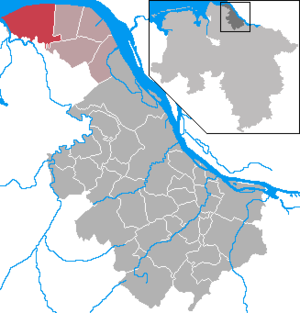
| Location of the municipality of Balje in the district of Stade | ||
  |
||

Balje [ ˈbaljə ] is a municipality in Lower Saxony in the Stade district and has been part of the municipality of Nordkehdingen since 1971 .
geography
Balje is located in the state of Kehdingen , between the Oste and the Elbe - the city of Brunsbüttel is on the opposite bank of the Elbe. The landscape is characterized by the Elbe dike, which is subdivided into the Hörner outer dike (directly at the mouth of the Oste) and Baljer outer dike, to the east the Wechtern outer dike and the Stellenfleth outer dike adjoin.
State road 111, which connects Freiburg / Elbe with Neuhaus (Oste) , runs through the local area .
The place is on the German ferry route .
The Kehdinger Land is a moor and marshland area and is partly below sea level. The cultivated land was therefore regularly flooded in the past. Only extensive embankments were able to permanently secure the area on the south bank of the Lower Elbe against storm surges .
Since Balje is still largely agricultural today, arable land, marsh meadows and fruit farms take up a large part of the district. The districts run along the streets that criss-cross the area. There is hardly any forest in the village.
Balje borders Neuhaus (Oste) and Belum in the west, Geversdorf in the south and Oederquart and Krummendeich in the east .
In addition to the actual place Balje, the following localities belong to the municipality:
- Elbe dike
- Listen
- Neuenhof
- Altenwisch
- Kukenbüttel
- Mill wipe
- Wipe
- Feldhof
- Lazy yards
- Outer dike
- Wehlken
- Baljerdorf
- Rittershausen
- Süderdeich-West
- Süderdeich-Ost
- rosary
- Hünkenbüttel
- Eggerkamp
- Breitendeich
- Weather dike
- Hullen bird sanctuary
- Eierdorf
history
The word Balje or Balge means (navigable) water channel in the mudflats. It stands for Low German belge "lower, swampy place, watercourse", balje, belge "ditch or hollow, in which there is still some water left over when the other one has run out", Low German belge "river channel, arm of a larger river, deep channel between sandbanks on the coast ”, Middle Low German bellows, convex“ depression in the mud flats that remains full of water even at low tide ”.
The Kehdinger Land originally represented an island landscape of the Lower Elbe, which only gradually disappeared around the turn of the times, with three larger islands forming: the Baljer Island, the Wechten Island and the Hamelwörden Island. Pliny, who reached the Elbe with a Roman fleet, reports that the Uferanier lived mainly from fishing, with nets made of reeds and rushes being turned.
Under the Carolingians, there was probably a customs post in Hamelwörden, a little east of today's Balje. Not only the Elbe itself served as a shipping route, but also its numerous side creeks, especially since the land routes were often difficult to pass and bridges, jetties and (later) locks ensured that shipping was also possible on the waterways of the marshland. In the course of the Middle Ages, typical bank vegetation developed on the amphibious landscape, which originally only consisted of silt, so that the area could be used as meadows, while the moor was an upland moor that was rather unsuitable for human use.
A stronger settlement of the moors did not take place until after the end of the Thirty Years War, when penniless day laborers in particular discovered the area as a settlement area, whereby they were usually assigned land by the marsh farmers. In addition to the agricultural use, the extraction of black peat, which was needed for the production of bricks, was carried out; however, the labor-intensive extraction did not survive industrialization, as more cost-effective competing products from other areas were now available.

Ecclesiastically, the community with its old church, which later burned down, was subordinate to the diocese of Bremen, to which it was also politically subordinate. Like other farming communities on the North Sea, the Kehdingen farmers always enjoyed a certain amount of autonomy. The counts and captains who administered the land in the name of the bishop were elected by the people, and the district court in Stade served as the court of appeal. In 1648 the area came to Sweden with the Peace of Westphalia. In 1719 it fell to the Electorate of Hanover, with whom it became Prussian in 1866. During the Second World War, Balje u. a. the stick battery of a naval flak department to protect the canal locks on the opposite side of the Elbe near Brunsbüttel. Balje has been part of the state of Lower Saxony since 1947. Originally it was a municipality in the Kehdingen district, which was integrated into the Stade district in 1932.

Population development
| year | 1987 | 1992 | 1997 | 2002 | 2007 | 2008 | 2009 | 2010 | 2011 |
|---|---|---|---|---|---|---|---|---|---|
| Residents | 1,173 | 1,221 | 1,114 | 1.107 | 1,098 | 1,068 | 1,049 | 1,051 | 1,025 |
(as of December 31st)
religion
The inhabitants of the Balje community are predominantly Evangelical Lutheran. The church is located in the Balje district.

St. Mary's Church

Parish hall of the ev.-luth. Parish

View of the town on the dike


politics
The council of the community is composed of
(Status: 2016 local elections)
Mayor is Hermann Bösch (CDU)
coat of arms
The coat of arms of Balje, which was awarded on April 26, 1948, shows a golden bell with a clapper floating in blue over a silver shield base with a wavy cut .
The coat of arms is reminiscent of a legend according to which the Baljer are said to have kidnapped the bells of the Brunsbüttel church during a flood. Then the bells are said to have called over in a westerly wind: "Well Brunsbüttel!" This is said to have lasted until one day the people of Brunsbüttel came to the aid of a flood in the Kehdinger Land, but left the bell to the Baljern.
Culture and sights
- The Natureum Niederelbe is a nature and open-air museum on an artificial peninsula between Ostesee and Oste, which presents the coastal nature with its typical flora and fauna to the visitor.
- The St. Marien Church was built in 1938 as a brick building on the site of the medieval church that burned down in 1936 and was first mentioned at the beginning of the 14th century.
- Medieval village "Op de Horn", in the Hörne district: estate with eight buildings in medieval style and a historic garden.
- The Balje lighthouse, built in 1903, went into operation on February 1, 1904. The massive clinker building generated its light first with petroleum, then with liquid gas and finally, since 1962, electrically. The beacon was shut down in 1980 after the nearby upper and lower Balje lights went into operation.
- The modern overhead light, which was put into operation in 1980 as a modern concrete tower, stands near the old lighthouse and reaches a height of 56.2 meters.
- The eastern barrier , which was erected from 1964 to 1968, consists of solid components with approx. 20,000 cubic meters of concrete. The shipping opening in the middle measures 22 meters and can be closed by steel mitred gates in the event of a storm surge. So that ships can pass the bridge of the barrage, its middle part is designed as a bascule bridge.

The Natureum

Old and new lighthouse in the outer dike

Medieval village "Op de Horn" in the Hörne district

Eastern barrier


Economy and Infrastructure

The following companies exist in the area: two bank branches (Kreissparkasse, Volksbank), the restaurant “Armer Ritter”, the hotel “Zwei Linden”, a guesthouse, companies for yacht equipment, dredging, window construction, wood construction, sewage technology, heating, electrical and sanitary facilities, steel construction , two carpenters, a taxi company, Superbrain Verlag & Service, as well as a number of fruit growers and a service provider for agricultural businesses.
The town is connected via the Freiburg – Geversdorf – Neuhaus road, where it connects to the B 73 . There is a bus line (2025) from Stade to Itzwörden-Geversdorf. The next train station is Cadenberge on the Cuxhaven - Hamburg route .
The northern section of the narrow-gauge Kehdinger Kreisbahn , which connected Balje with Freiburg / Elbe and Itzwörden, was shut down in 1933 and completely dismantled by 1935.
Son of Baljes
Hermann Schlichting (1907–1982), fluid mechanic in Braunschweig and Göttingen
Web links
Individual evidence
- ↑ State Office for Statistics Lower Saxony, LSN-Online regional database, Table 12411: Update of the population, as of December 31, 2019 ( help ).
- ^ Jürgen Udolph (research): The "place name researcher". In: website NDR 1 Lower Saxony . Archived from the original on December 28, 2014 ; accessed on August 3, 2019 .
- ↑ LSKN-Online
- ↑ www.natureum-niederelbe.de ( Memento of the original from July 12, 2015 in the Internet Archive ) Info: The archive link was inserted automatically and has not yet been checked. Please check the original and archive link according to the instructions and then remove this notice.
- ^ The church at www.organistenhaus-balje.de
- ↑ Oste barrage on www.wsa-cuxhaven.de
Agathenburg | Ahlerstedt | Apenses | Balje | Bargstedt | Beckdorf | Bliedersdorf | Brest | Burweg | Buxtehude | Yours | Dollern | Drochtersen | Düdenbüttel | Engelschoff | Estorf | Fredenbeck | Freiburg / Elbe | Grossenwörden | Grünendeich | Guderhandviertel | Hammah | Harsefeld | Heinbockel | Himmelpforten | Hollern-Twielenfleth | Horneburg | Jork | Kranenburg | Crooked dike | Kutenholz | Mittelkirchen | Neuenkirchen | Nottensdorf | Oederquart | Oldendorf | Sauensiek | Stade | Stone churches | Wischhafen