
Harsefeld
| coat of arms | Germany map | |
|---|---|---|

|
Coordinates: 53 ° 27 ' N , 9 ° 30' E |
|
| Basic data | ||
| State : | Lower Saxony | |
| County : | Stade | |
| Joint municipality : | Harsefeld | |
| Height : | 38 m above sea level NHN | |
| Area : | 51.81 km 2 | |
| Residents: | 13,894 (Dec. 31, 2019) | |
| Population density : | 268 inhabitants per km 2 | |
| Postal code : | 21698 | |
| Primaries : | 04164 (Issendorf 04163) | |
| License plate : | HOURS | |
| Community key : | 03 3 59 023 | |
| LOCODE : | DE HFD | |
| Community structure: | 4 districts | |
| Address of the municipal administration: |
Herrenstrasse 25 21698 Harsefeld |
|
| Website : | ||
| Mayor : | Harald Koetzing (SPD) | |
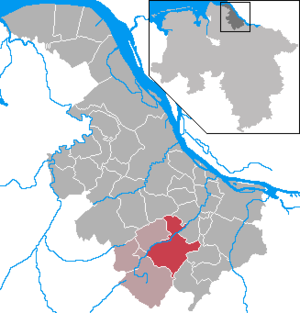
| Location of the community Harsefeld in the district of Stade | ||
  |
||

Harsefeld ( Low German Ha (r) sfeld ) is a town in the district of Stade , Lower Saxony . From 1104 to 1648 the Harsefeld Monastery , an important Benedictine abbey, existed here . Subsequently, Harsefeld was the administrative seat of the Harsefeld office for centuries and today the eponymous place for the Harsefeld community .
geography
Geographical location
Harsefeld is located on the Zevener Geest belonging to the Stader Geest in the Elbe-Weser triangle between the cities of Buxtehude , Stade and Zeven and in the agglomeration of Hamburg, 34 km away as the crow flies . Bremen is 63 km away as the crow flies; Harsefeld is conveniently located between the two metropolises. The area is surrounded by the joint municipality of Fredenbeck in the north, the joint municipality of Horneburg in the northeast, the joint municipality of Apensen in the east and southeast and the joint municipality of the same name in the south, southwest, west and northwest.
structure
In addition to the core town, the patch consists of the following districts:
The two districts of Griemshorst and Weißenfelde have historically always belonged to Harsefeld, all other districts were incorporated into Harsefeld as part of the regional reform on July 1, 1972. Before they were incorporated, Issendorf and Ruschwedel formed a joint municipality with Harsefeld from 1967 to 1972 .
Neighboring communities
The following municipalities border the Harsefeld area, starting clockwise from the north:
- Joint municipality Fredenbeck with the municipality Deinste
- Joint municipality Horneburg with the municipality Bliedersdorf
- Joint municipality Apensen with the municipalities Apensen and Sauensiek
- Integrated community Harsefeld with the communities Ahlerstedt and Bargstedt
Nearest cities
|
Hemmoor 44 km , Cuxhaven 88 km |
Stade 17 km |
Jork 18 km |
|
Bremervörde 30 km , Bremerhaven 71 km |
.svg)
|
Buxtehude 16 km , Hamburg 69 km |
|
Zeven 26 km , Bremen 89 km |
Sittensen 23 km , Rotenburg (Wümme) 57 km |
Tostedt 30 km , Buchholz in the north heath 43 km |
Waters

The small river Aue runs through the community and flows through Klein Hollenbeck , the northern edge of the core town and Issendorf . The river forms a valley here, the Auetal, which is designated as a landscape protection area and partly as a nature reserve ( floodplain and side valleys ). The floodplain flows together with the Landwetter to Lühe in Horneburg and flows into the Elbe after another ten kilometers .
The Aue has some tributaries, such as the Rellerbach , which flows through the core town and flows into the Aue near the municipality border with Bargstedt, and the Steinbeck , which rises near Kammerbusch, flows through Ruschwedel and the Steinbeckforst and near the municipality border with Bliedersdorf in the Aue flows. The Rellerbach is partially dammed into ponds.
By the breakdown of gravel , sand and clay , some small in Harsefeld lakes emerged as the Tonkuhle and the lake in the former gravel pit Am Sande . There are efforts to put the former gravel pit under nature protection. At the moment there is mainly fishing there. A tourist use is likely to be absent. There are also numerous small and large ponds in the municipality.
geology
Harsefeld is located on the Harsefelder Geest, which belongs to the Zevener Geest, and is therefore predominantly located on Geestboden . Small forests and the meadow valleys of the floodplain shape the slightly hilly landscape. Larger elevations in the municipality are the Ehrensberg and the Mühlenberg . Except for the 694 hectare Braken natural forest , the Harselah near Griemshorst and the Steinbeckforst, as well as the forest areas in the Aueniederung and side valleys nature reserve, not much has been preserved of large forest stands ; large parts of the landscape were cultivated for agricultural purposes. The forest areas Wieh and Meinkenhop also extend on the western and southwestern edge of the core town . Some moor areas have also been preserved, for example the Kahle and Wilde Moor , a drained high moor with extensive stocks of beech - pine - moor forest .
climate
The climate in Harsefeld is warm and temperate . There is more rainfall than average , even in the driest month. The annual average temperature is 8.4 ° C. The annual precipitation amounts to 753 mm. The warmest month is July, the coldest January. The wettest month is February, August is the wettest.
|
Monthly average temperatures and precipitation for Bremervörde, Lower Saxony
|
||||||||||||||||||||||||||||||||||||||||||||||||||||||||||||||||||||||||||||||||||||||||||||||||||||||||||||||||||||||||||||||||||||||||||||||||||||||
history

To the northeast of Harsefeld there are 22 burial mounds on the Hohekamp. The largest burial mound at the highest point had a diameter of almost 25 meters and a height of four meters. The royal grave mound - also called "Osterberg" - was dug through by the owner in 1910/11. An archaeological investigation took place.
The construction of Harsefeld Castle is dated in the chronicle of Thietmar von Merseburg to 969 AD. It was the seat of the Udons until the establishment of the County of Stade . After their resignation, the area was used as Harsefeld Monastery by the Benedictine Order with a church built in the 15th century . In 1546 the monastery and church were almost completely destroyed by the knight Pentz from Mecklenburg due to financial debts. The late Gothic abbey church of St. Marien and Bartholomäi was rebuilt in 1648 with a tower.
“Below Harsefeld, the Steinbach flows into the Lühe, which is why Harsefeld, on the left side of the Steinbach, falls to Bremen,” wrote landscape director Wilhelm von Hodenberg in 1858. “In the actual Harsefeld is Geest, watered by the Aue and Lühe; Old and new monasteries, located on the Este, usually have boggy ground, ”explains Peter von Kobbe in 1824.
The official courtyard building built in 1740 on the edge of the monastery complex is also of historical importance. The Friedrich Huth library is located there. It was donated in 1845 by the cultural patron Friedrich Huth (1777–1864). The merchant grew up in Harsefeld and made a considerable fortune as a banker in London. Shortly before his death he visited his homeland again and decided to donate a public library for the citizens of Harsefeld. For this he donated 1750 gold thalers. Initially the library comprised around 1,000 volumes, and soon afterwards there were 3,000 copies. The library is still one of the best equipped in the Stade district. In 1998, in honor of the generous donor, a larger than life bronze bust was unveiled in front of the courtyard. The work of art was created by the sculptor Carsten Eggers .
On May 30, 1799, a total of 80 residential and auxiliary buildings burned down in the Harsefeld patch. At 11 o'clock at noon, when the residents were working in the fields, the conflagration started, as reported in the "Hanoverian advertisements" of June 17, 1799. Within four hours, 53 houses with 21 outbuildings, including the rectory, burned down. Little has been saved. 64 families have become homeless and robbed of their belongings and goods.
Meaning of the name
It is estimated that harp is derived from the Old Saxon horsa or hers = Ross , horse, so that the name can be interpreted Harsefeld with "Field of Horses" or "field of the horses." This interpretation is also supported by name variants in medieval documents (see below), such as Herseveld (969), Rossenvelde (1101) and so on.
Another theory is that harse should come from millet.
Another tradition says that the name Harsefeld was given by the first settlers. According to tradition, they let a blind horse run until it stopped to graze in a lush pasture. The Harsefeld settlement was founded on this pasture, which, as described above, is certainly derived from the Old Saxon term horsa for horse.
Mention in old documents
Various sources provide information about Harsefeld and its medieval spellings.
a. 969. [Comes Heinricos de Stadhe] construxit castrum in loco qui Herseveld dicitur. - a. 979. Duobus monasteriis, scilicet in Alesleve et Hersevelden constitutis… - a. 1010. Heinricus comes, filius Heinrici de Stathe, destruxit castrum Herseveld , quod pater suus exstruxerat, et fecit ex eo monasterium et congregationem canonicorum. - a. 1087. Iste Udo et mater eius… expulerunt clericos de loco sue constructionis Herseveld et posuerunt illic monachos. - a. 1101. Congregatio monachorum in Rossenvelde cepit institui… - a. 1106. Udo, marchio aquilonaris ... ad locum qui Rossenvelde dicitur est delatus, ... de hoc seculo migravit ... Thietmar (a. 994) and Albert v. Stade (a. 1144) commemorate the civitas Hersevel and the castrum Hersevelde .
Incorporations
On July 1, 1972, the communities of Hollenbeck, Issendorf and Ruschwedel were incorporated. In addition, a part of the municipality of Bargstedt, with around 100 inhabitants at that time, was added.
religion
Religious Statistics
With around 7,000 Protestants, Harsefeld is strongly evangelical-Lutheran (54.2%). With a share of 5.9% there is a small Roman Catholic minority. The remaining 39.8% of the population did not confess to any denomination or belong to other denominations / religions (as of May 2011).
Evangelical Lutheran parish Harsefeld

The Evangelical Lutheran parish is the largest parish in the parish area. It is responsible for the towns of Harsefeld, Weißenfelde and Griemshorst and is divided into two parishes. Services are held every Sunday at 10 a.m.
The church building of the parish is the St. Marien and Bartholomäi Church in the monastery park. It was the collegiate church of the Harsefeld monastery . The current church building was built in 1583 after the old church burned down after two fires in the 16th century and was rebuilt several times. It was given its current form in the neo-Gothic style in 1856/60. Extensive renovations took place in the 1950s and 2014.
The Prostestants from the districts of Hollenbeck and Issendorf, which are also evangelical-Lutheran, are parish in Bargstedt or Ruschwedel in Apensen for historical reasons .
Other communities
- Roman Catholic parish of the Assumption of Mary: The Harsefelder St. Michaelskirche, built in 1967, has been a branch church of the Buxtehude parish of the Assumption of Mary since September 1, 2010 . About 1000 Catholics live in the catchment area, which also includes the entire congregation.
- New Apostolic Church
politics
Municipal council
The municipal council is the municipal representative of the Harsefeld area. Every five years, citizens decide on the allocation of the 31 seats in a general, direct, free, equal and secret ballot.
The diagrams opposite provide information about the results of the municipal elections on September 11, 2016 .
mayor
Michael Ospalski ( SPD ) has been the mayor of the Fleckens since November 2011 . As of 2019, Harald Koetzing is the new mayor.
Coat of arms, flag
Blazon : “In silver, a black knight on a black jumping horse bridled with gold . In the blue head of the shield three gold roses and in the blue base of the shield two gold roses . "
The community bears the coat of arms of the former office of Harsefeld, which was created on the property of the monastery founded by the Harsefeld counts. The coat of arms is eloquent (Harsefeld = Horse = Ross, but also the meaning in rose instead of Ross occurs). The coat of arms is approved by decree of the Lower Saxony Minister of the Interior on July 9, 1948.
The flag is blue and white (1: 1) striped and has the coat of arms in the center.
Town twinning
Culture and sights
Sights and monuments
Harsefeld District Court

In the monastery park is the old Amtshof (Abtshof) from 1742, the vaulted cellar of which dates from the monastery era around the 11th century. The abbot used the house as a residence and wine cellar. Later this was the administrative seat of the Harsefeld district . The historic vaulted cellar is used for gastronomy today; the rest of the building has housed the Friedrich Huth library, which was donated by patron Friedrich Huth in 1845, since 1980 . Readings, cabarets, concerts and children's theater take place here regularly.
Garden of stones

The Garden of Stones was opened in 2003 on Ehrenberg, northeast of Harsefeld , an exhibition area that is open all year round and shows 170 boulders , including flint , granite and basalt . They come mainly from fields and sand pits that were dug for the construction of the A26 motorway . With the help of the stones and other explanations on boards, geological processes are explained to the visitor, the use of erratic boulders is illustrated or the processes involved in rock formation are described. The visitor goes through twelve stations that form a tour through the garden.
Grefenkreuz
The Grefenkreuz is located on the L 124 between Harsefeld and Helmste-Feldkurg on a prehistoric burial mound . This landmark originally served as a border marker between the jurisdiction of the Harsefeld Monastery and that of the Horneburg Patrimonial Court . Worrynate Grefen were active in the administration of precisely defined small areas. In addition, the Grefenkreuz served as an orientation for travelers in the desolate heathland, where there used to be an intersection. Even Carl Friedrich Gauss peilte with his land surveying to the Grefe Cross in the 1840s.
War memorials
- Harsefeld war memorial
- Hollenbeck war memorial
- Ruschwedel war memorial
- War memorial Issendorf
additional
- Numerous old half-timbered houses in the city center


Museums
Harsefeld Museum

The Harsefelder Museum in the monastery park was opened in 1986. The exhibition "Burg, Stift, Kloster Harsefeld" is located on the ground floor with information and exhibits from the time of the castle, its relocation to Stade 969 and the development of the monastery into a Benedictine monastery. Finds and findings from the monastery excavations from 1981 to 1984 such as B. Book fittings, pens, eating and drinking equipment exhibited. The exhibition "5000 years of life on the floodplain" and the Friedrich Huth room can be found on the top floor.
The museum is located in the former court and registry building from 1776, the foundations of which come from an economic building from the monastery period from 1101 to 1647.
Guided tours are possible by appointment and admission is free.
Natural monuments
| number | designation | place | location | Coordinates | image |
|---|---|---|---|---|---|
| ND STD 00017 | Boulder | Harsefeld | Braken , Harselah , Kahles and Wildes Moor ; southeast of Hollenbeck | 53 ° 25 '19.7 " N , 9 ° 29" 18.5 " E | |
| ND STD 00018 | Boulder | Harsefeld | Braken, Harselah, Kahles and Wildes Moor; southeast of Hollenbeck | 53 ° 25 '14.9 " N , 9 ° 28' 55.8" E | |
| ND STD 00030 | Boulder | Harsefeld | Braken, Harselah, Kahles and Wildes Moor; southeast of Hollenbeck | 53 ° 25 '45.1 " N , 9 ° 28' 55.7" E | |
| ND STD 00031 | Boulder | Harsefeld | near the Hollenbeeke; northwest of Hollenbeck | 53 ° 26 '22.6 " N , 9 ° 27' 19.4" E | |
| ND STD 00032 | Boulder | Harsefeld | Butter bog; southwest of Hollenbeck | 53 ° 26 '2 " N , 9 ° 27' 12.2" E | |
| ND STD 00033 | Boulder | Harsefeld | Am Brink; northwest of Hollenbeck | 53 ° 26 '25.1 " N , 9 ° 27' 3.6" E | |
| ND STD 00046 | Boulder | Harsefeld | Braken, Harselah, Kahles and Wildes Moor; southeast of Hollenbeck | 53 ° 25 ′ 34.5 " N , 9 ° 28 ′ 43.3" E | |
| ND STD 00047 | Boulder | Harsefeld | Braken, Harselah, Kahles and Wildes Moor; southeast of Hollenbeck | 53 ° 25 ′ 18.8 " N , 9 ° 28 ′ 20.6" E | |
| ND STD 00048 | Boulder | Harsefeld | Braken, Harselah, Kahles and Wildes Moor; southeast of Hollenbeck | 53 ° 25 ′ 19.8 " N , 9 ° 28 ′ 24.5" E |
Green spaces and recreation
Monastery park

The monastery park is located in the center of Harsefeld. There you will find the historical ensemble of the Amtshof , museum, war memorial, church and the historical excavation site of the Harsefeld monastery . In the 1980s, the remains of the Harsefeld monastery could be excavated on the historical excavation site. So the structure of the foundation walls of the taster became visible. In the monastery park there are also extensive green areas, ponds and small forest stands . The Rellerbach flows through the park.
The monastery park has been one of the gardens of Europe since 2003 . Renovation work took place in 2012/13.
Monastery mile

The monastery mile is a circular route. It starts at the church and runs through the former monastery grounds, past the Amtshof and the pond and then over several bridges (the longest of which is 200 m) over Rellerbach and Bruchwald to Herrenstraße. Now the monastery mile leads from the town hall to the monastery ponds, which were created by the monks in the Middle Ages and are now designated as part of a landscape protection area.
In 1986, Harsefeld received an award for the park design as part of the state competition for building close to nature .
Ehrensberg and Auetal

The Ehrenberg was dedicated to the Germanic deity Tiu or Er. Here are the remains of burial mounds from the Bronze Age and the Garden of Stones.
Numerous hiking trails lead through the Auetal conservation area. Two bridges connect this across the floodplain with Issendorf.
Daudieck necropolis - archaeological educational trail
In the area of the north-western municipal boundary between Issendorf and Daudieck ( Horneburg ) there are around 50 barrows from the Neolithic Age . The body graves of the Old Saxons from the 5th century are particularly worth seeing . A circular path with information boards leads through the area. From here you also have a beautiful view of the Auetal.

Brakes
Numerous hiking trails lead through the 600 hectare Braken natural forest.
graveyards
The largest cemetery in the core town is the Gierenberg cemetery near the town hall. In addition, there is the Upper Cemetery near the Catholic Church of St. Michael. This cemetery has a size of about 10,000 m².
In 1985 the Ehrenberg cemetery was opened on the outskirts. The thus youngest cemetery in the area has a size of about 55,000 m².
The three cemeteries belong to the St. Marien and Bartholomäikirche .
The districts of Ruschwedel , Issendorf and Hollenbeck each have their own cemeteries, which are parish in Bargstedt and Apensen .
Sports

The sports club TuS Harsefeld offers many sports, such as football and swimming. Since the 2009 season, TuS Harsefeld has had a youth play community with TSV Apensen in grades U13 to U19.
The football club has been playing in the six-class Lüneburg regional league since the 2014/15 season . The home games are played in the Waldstadion (4000 seats).
With the only ice rink in the Stade district , Harsefeld is the center of "cold" sports, including ice hockey . The ice hockey department of TuS Harsefeld, the Harsefeld Tigers , take part in the games of the Lower Saxony Ice Sports Association (NEV). The ice rink was renovated in summer 2009.
Economy, transport and infrastructure
Companies
The solid house manufacturer Viebrockhaus has its headquarters in Harsefeld.
In addition, the Holtermann farm with a biogas plant and laying hen house is located in Harsefeld-Weißenfelde.
media
In Harsefeld, the Stader Tageblatt (with Buxtehuder Wochenblatt ), the district newspaper Wochenblatt and the Wednesday journal as well as the community newspaper Auf der Geest are distributed. Supraregional print media are mainly obtained from the greater Hamburg area , radio media come from Bremen and Hamburg .
Public facilities
- Town hall complex: The Harsefeld town hall houses, among other things, the community and all-inclusive community administration, the residents' registration office, the vehicle registration office, the registry office, the social station and the community archive. The complex is located at Herrenstrasse 25
- Harsefeld Forestry Office, Am Amtshof 1
- Youth meeting place (JUBS), Jahnstraße 15
- Deutsche Post AG , Marktstrasse 20
- EWE , Markstrasse 20
- Family Information Center (FIZ), Herrenstrasse 25a
public safety
- Harsefeld Police Station, Am Rosenborn 5
- Harsefeld Volunteer Fire Brigade : The Harsefeld Volunteer Fire Brigade, founded in 1893, is a priority fire brigade. The fleet consists of a command vehicle 1 (ELW 1), a fire fighting group vehicle (LF 16-12), an emergency fire fighting group vehicle (HLF 20-16), a fully automatic turntable ladder with basket (DLAK 23-12), a decontamination truck for people (Dekon-P) , a team transport vehicle (MTF), a multi-purpose vehicle (MZF) and a classic car - Tanklöschfahrzeug . In 2014/15 a hall was added to the fire station . There is also a youth fire brigade and an age and honor department. In addition to the fire brigade in the core town, there are three other local brigades in the municipality.
The rescue service as throughout the county by the German Red Cross ensured. The ambulance station is located in neighboring Bargstedt and is responsible for both the Harsefeld community and the Fredenbeck community . An ambulance and a multi-purpose vehicle are regularly stationed at the ambulance .
The district court responsible since the closure of the Harsefeld District Court is the Buxtehude District Court .
education
Day care centers
- Forest kindergarten "Die Naturforscher"
- DRK day care center "Am Feldbusch"
- DRK day care center "Löwenzahn"
- DRK day care center "Rappelkiste"
- DRK day care center "Villa Kunterbunt"
- DRK day care center "Hand in Hand"
- DRK day care center in Ruschwedel
- DRK day care center “Lummerland”, Hollenbeck
schools
There are two primary schools in the municipality.
- Rosenborn Primary School, Meybohmstrasse
- Elementary school am Feldbusch, since 2001

All secondary schools , with the exception of the special needs school, are located at the Jahnstraße / Brakenweg school center.
- Balthasar Leander School , Meybohmstraße: The school types are special schools.
- Selma-Lagerlöf-Oberschule , Jahnstraße, since 1973; the secondary school was at the time at the Rosenborn primary school. Later, the secondary school and the secondary school with two separate administrations were relocated to the building on Jahnstrasse. Since 2004, the two schools have been combined into one school ( secondary school ).
- Aue-Geest-Gymnasium Harsefeld since 2004; New building from 2006
Other institutions
- Harsefeld Adult Education Center
- Harsefeld youth art school
Healthcare
Harsefeld is located in the catchment area of the Elbe clinics in Buxtehude and Stade . In Harsefeld itself there is a wide range of general practitioners, dentists, veterinarians as well as physiotherapy and learning therapy and a few other specialists (including ENT doctor and gynecologist). There are also three pharmacies in the center of town.
The two nursing homes, Haus Am Rosenborn and Aueterassen, as well as a nursing service and the social station ensure care for older residents in Harsefeld.
Transport links
Street
Harsefeld is not directly connected to the trunk road network. The state road 124 ( Zeven - Stade ) leads in a northerly direction via Helmste to Stade to the federal road 73 and in a south-westerly direction via Ahlerstedt and Heeslingen to Zeven to the federal road 71 . The L 123 ( Bremervörde - Horneburg ) runs through the district of Issendorf and connects it with Bremervörde and the federal road 71 and with Horneburg and the federal road 73. The core town is connected to the regional road 123 via the county road 46. There is a connection to Landesstraße 127 ( Wangersen - Buxtehude ) via Kreisstraße 53 .
Harsefeld is connected to the local traffic network via the district roads 53 (Harsefeld - Sauensiek ), Kreisstraße 46 (Harsefeld - Ohrensen ) and 27 II (Harsefeld - Hedendorf ). The K 46 connects the core town with the districts of Griemshorst and Weißenfelde and Revenahe-Kammerbusch . The K 27 II leads via Rutenbeck to federal highway 73 in Hedendorf. District road 49 branches off from K 27 II ( Apensen –Rutenbeck), which connects the Ruschwedel district with the core town. The district road 49 joins the L 130, which offers a connection to the federal road 73 in Horneburg and in Scheeßel to the federal road 75 . Buxtehude can also be reached via Apensen. The K26n acts as a bypass in the center of town.
The next end of the motorway is in Sittensen, about 20 km away, to the federal motorway 1 ( Heiligenhafen - Saarbrücken ). There is a good connection to the metropolises of Hamburg and Bremen via the BAB 1 . Other important connections to Hamburg are federal highways 73 and 3.
With the construction of the federal highway 26 (Stade-Hamburg) a direct connection to the federal highway 7 in Hamburg-Moorburg is to be realized. It currently ranges from Stade to Buxtehude. The next junction in is about 15 km away in Horneburg. The section of the federal motorway 20 near Stade, which is currently being planned, is intended to create a further possibility of crossing the Elbe . The BAB 22 should split off from the BAB 20 at some point and lead to the Weser Tunnel .
The table lists the long-distance traffic connections in and near Harsefeld with street category , street number, street course (includes a selection of cities and towns) as well as comments on the respective connection.
rail

With the station of the same name, Harsefeld is connected to the Bremerhaven – Buxtehude railway line, as is the Ruschwedel district , which is mainly used for passenger transport. The route is operated and maintained by EVB and offers a connection to the train stations Bremerhaven Hauptbahnhof , Bremervörde and Buxtehude . Of supraregional importance, however, is the Buxtehude train station about 14 km away , which is connected to Hamburg , Cuxhaven and Stade via the Niederelbebahn .
| line | Line course | Cycle (min) | EVU |
|---|---|---|---|
| RB 33 | ( Cuxhaven - Dorum -) Bremerhaven Hbf - Geemmeneth - Bremervörde - Harsefeld - Buxtehude | 60 | EVB |

Harsefeld received its first rail link in 1902 with the construction of the Buchholz – Bremervörde – Bremerhaven line . In 1928 the line to Buxtehude was added. Passenger traffic was discontinued on both routes in 1968/1969; Since 1993, Harsefeld has been approached by EVB passenger trains again, which commute between Bremerhaven and Buxtehude station .
In the roundhouse Buxtehude Harsefelder entertain Eisenbahnfreunde a historical WUMAG railcars Nuremberg 761 of 1926 and other historic vehicles, inter alia on a converted rail operation Opel Olympia Rekord of the 1,953th
Personalities
Honorary citizen
- Since September 1, 2018: Gustav Viebrock (1929–2019), entrepreneur, founder of the Viebrockhaus company in Harsefeld
Born in Harsefeld
- Otto Albrecht von Düring (1807–1875), Minister of Justice of the Kingdom of Hanover
- Franz Adickes (1846–1915), Lord Mayor of Frankfurt am Main
- Willi Wegewitz (1898–1996), archaeologist and local history researcher
- Richard Podloucky (* 1947), biologist
- Jürgen Fitschen (* 1948), head of Deutsche Bank
- Angelika Mertens (1952–2019), SPD politician
- Uwe Ruprecht (* 1958), writer and journalist
Connected to Harsefeld
- Johann Friedrich Andreas Huth = Frederick Huth (1777–1864), important merchant and banker in London
- Heinrich Behnken (1880–1960), teacher and Low German author
literature
- Journal of the historical association for Lower Saxony , part 1. Ed. Under the direction of the association committee, Hanover 1856, in the Hahn'schen Hofbuchhandlung, p. 234
- Adolf Peter Krönke: Der Flecken Harsefeld his way through history , published on behalf of the Fleckens Harsefeld, printing and clichés: A. Pockwitz Nachf. Karl Krause, Stade, 343 pages.
- Adolf Peter Krönke: Stories and Döntjes from the home country , Volume 2, worked through and edited by Hinrich Gerken, Verlag Kreissparkasse Harsefeld 1989. DNB-Link
Web links
Individual evidence
- ↑ State Office for Statistics Lower Saxony, LSN-Online regional database, Table 12411: Update of the population, as of December 31, 2019 ( help ).
- ^ Census database - results of the 2011 census. Accessed April 23, 2020 .
- ↑ The prehistory of the later Benedictine monastery Harsefeld began around 1002. As atonement for their participation in the murder of Margrave Eckhard I of Meißen, the brothers Heinrich and Udo von Katlenburg are said to have founded a monastery for secular priests in Harsefeld at that time. (Hinrichs, Wiard, Stupor Saxoniae inferioris: Ernst Schubert on his 60th birthday, Göttingen 2001, p. 20 f.)
- ^ Wilhelm von Hodenberg: The diocese of Bremen and its districts in Saxony and Friesland. Celle 1858, p. 41.
- ^ Peter Ludwig Christian Kobbe: History and description of the country of the duchies of Bremen and Verden, first part. Göttingen 1824, p. 39.
- ↑ Blazek, Matthias, Das Löschwesen in the area of the former Principality of Lüneburg from the beginnings to 1900, Adelheidsdorf 2006, p. 165, ISBN 978-3-00-019837-3 .
- ↑ Metathesis: hers ( 'Ross') from HROS F. Holthausen, Altsächsisches Elementarbuch , Heidelberg 1921. 65 S.
- ↑ Quoted from: Mélanges russes tirés du bulletin historico-philologique de l'Académie impériale des sciences de St.-Pétersbourg (1849-1851), Volume 1, Saint Petersburg 1851, p. 332.
- ^ Federal Statistical Office (ed.): Historical municipality directory for the Federal Republic of Germany. Name, border and key number changes in municipalities, counties and administrative districts from May 27, 1970 to December 31, 1982 . W. Kohlhammer, Stuttgart / Mainz 1983, ISBN 3-17-003263-1 , p. 246 f .
- ^ Census database - results of the 2011 census. Accessed April 22, 2020 .
- ↑ St. Marien and Bartholomäi. Retrieved January 20, 2020 .
- ↑ St. Michael | Assumption of Mary, Buxtehude. Retrieved January 20, 2020 .
- ↑ Home. August 3, 2018, accessed January 20, 2020 .
- ↑ Results of the local election of Lower Saxony 2016 Fleckenrat Harsefeld on harsefeld.de, accessed on April 24, 2017
- ↑ http://www.abendblatt.de/region/stade/article2082169/Michael-Ospalski-ist-neuer-Harsefelder-Buergermeister.html
- ↑ LGLN: GeoLife - the leisure portal in Lower Saxony - geolife.de . Archived from the original on April 7, 2014. Retrieved April 4, 2014.
- ↑ Samtgemeinde Harsefeld (ed.): Harsefeld ... nice here! Information brochure . 9th edition. Harsefeld 2017, p. 39 f .
- ^ Wizard Computersysteme GmbH: Museum Harsefeld Ulrike Riepe - Harsefeld, museums. In: www.kreis-stade.de. Retrieved April 1, 2016 .
- ↑ a b c d e f g h i environmental maps. Retrieved January 23, 2020 .
- ↑ Bargstedt ambulance station. Retrieved February 10, 2020 .
- ↑ Harsefeld municipality. In: www.harsefeld.de. Retrieved April 1, 2016 .
Agathenburg | Ahlerstedt | Apenses | Balje | Bargstedt | Beckdorf | Bliedersdorf | Brest | Burweg | Buxtehude | Yours | Dollern | Drochtersen | Düdenbüttel | Engelschoff | Estorf | Fredenbeck | Freiburg / Elbe | Grossenwörden | Grünendeich | Guderhandviertel | Hammah | Harsefeld | Heinbockel | Himmelpforten | Hollern-Twielenfleth | Horneburg | Jork | Kranenburg | Crooked dike | Kutenholz | Mittelkirchen | Neuenkirchen | Nottensdorf | Oederquart | Oldendorf | Sauensiek | Stade | Stone churches | Wischhafen