
Aue (Lühe)
| Aue | ||
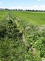
 The floodplain near Harsefeld (June 2017) |
||
| Data | ||
| Water code | EN : 596 | |
| location | Lower Saxony , Germany | |
| River system | Elbe | |
| Drain over | Lühe → Elbe → North Sea | |
| source | At Ahlerstedt 53 ° 24 ′ 42 ″ N , 9 ° 29 ′ 12 ″ E |
|
| Source height | 43 m above sea level NN | |
| muzzle | In Horneburg the confluence with the Landwetter zur Lühe coordinates: 53 ° 30 '43 " N , 9 ° 35' 27" E 53 ° 30 '43 " N , 9 ° 35' 27" E |
|
| Mouth height | 2 m above sea level NN | |
| Height difference | 41 m | |
| Bottom slope | 1.3 ‰ | |
| length | 31.5 km | |
| Discharge at the Oersdorf A Eo gauge : 28.1 km² Location: 20.8 km above the mouth |
NNQ (August 11, 1992) MNQ 1983–2014 MQ 1983–2014 Mq 1983–2014 MHQ 1983–2014 HHQ (July 18, 2002) |
26 l / s 66 l / s 328 l / s 11.7 l / (s km²) 3.68 m³ / s 7.98 m³ / s |
| Left tributaries | Tiefenbach | |
| Right tributaries | Brakengraben, Steinbeck , Landwetter , Rellerbach | |
| Communities | Ahlerstedt , Bargstedt , Harsefeld , Bliedersdorf , Horneburg | |
The Aue ( ) is a 31.5 kilometer long river in the Lower Saxony district of Stade in Germany .
geography
The floodplain rises near Ahrensmoor-Nord on the edge of a raised bog in the municipality of Ahlerstedt and flows through the villages
- Ahrensmoor-West ,
- Ahrenswohlde ,
- Bokel ,
- Klethen ,
- Oersdorf ,
- Kakerbeck ,
- Bargstedt / Klein Hollenbeck ,
- Harsefeld ,
- Issendorf and
- Bliedersdorf
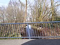
to Horneburg . Here it flows together with the Landwetter , changes its name to Lühe and flows into the Elbe after another 12.7 km .
Flood
In August 2002, a flood caused by prolonged and heavy rainfall in the river's catchment area broke the dikes in Horneburg and caused considerable property damage there. Horneburg reacted to the threat of further floods with a stronger quay wall in the town center and a dike renovation.
gallery
Aue in Ahrensmoor

Aue at Ahrenswohlde
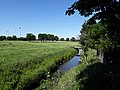
Aue in Oersdorf
Aue in Klethen
Aue in Kakerbeck

Source of the floodplain near Ahrensmoor-Nord


Individual evidence
- ^ German Hydrological Yearbook Elbe Region, Part III 2014. (PDF) ISSN 0949-3654. Free and Hanseatic City of Hamburg, Hamburg Port Authority, p. 157 , accessed on October 4, 2017 (German, at: dgj.de).
Web links
- Driving rules for the Lühe and Aue , published by DKV (PDF)