
Beckdorf
| coat of arms | Germany map | |
|---|---|---|

|
Coordinates: 53 ° 25 ' N , 9 ° 37' E |
|
| Basic data | ||
| State : | Lower Saxony | |
| County : | Stade | |
| Joint municipality : | Apenses | |
| Height : | 40 m above sea level NHN | |
| Area : | 21.9 km 2 | |
| Residents: | 2660 (Dec. 31, 2019) | |
| Population density : | 121 inhabitants per km 2 | |
| Postal code : | 21643 | |
| Area code : | 04167 | |
| License plate : | HOURS | |
| Community key : | 03 3 59 006 | |
| LOCODE : | DE B2D | |
| Community structure: | 3 districts | |
| Address of the municipal administration: |
Buxtehuder Strasse 27 21641 Apensen |
|
| Website : | ||
| Mayor : | Tomáš Jan Gold ( CDU ) | |
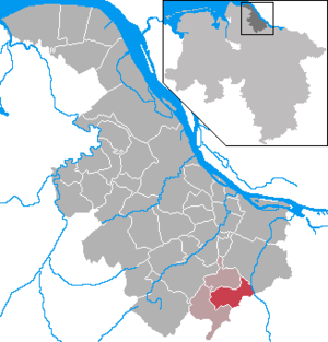
| Location of the community Beckdorf in the district of Stade | ||
  |
||

Beckdorf ( Low German Beekdorp ) is a municipality in Lower Saxony in the south of the Stade district , about 25 km southwest of Hamburg . Its middle center is Buxtehude . The districts Goldbeck and Nindorf belong to the community.
geography
location
Beckdorf is located on the Geest am Goldbach (a tributary of the Este ), about 8 kilometers south of the Altes Land and the glacial valley of the Elbe , west of the Harburg Mountains and a little further northwest of the Lüneburg Heath Nature Park . In the west lies the Beckdorfer Moor . The center itself is located on a hill in the Goldbachtal, about 2.5 kilometers north of the Litberg , which at 65 m is the highest elevation in the Stade district .
structure
In addition to the main town, the municipality also includes two other districts:
- Goldbeck ( location ): Further downstream on the Goldbach lies the Goldbeck district, which has retained its almost unchanged appearance from the middle of the 20th century. The agriculture is omnipresent, as it was in all places of the region once. From here you can best hike the nearby Litberg , which is located south in the direction of Sauensiek . There are some gravel pits to the east of the village . The Goldbeck burial ground lies between Goldbeck and Rahmstorf .
- Nindorf ( location ): The district is located near the Este in the northeast of the municipality. Almost all of its access roads are single-lane paved back roads. Together with the somewhat remote location of the place, this ensures pleasantly little through traffic. This district has also retained its rural character.
To the north of Nindorf is Klein Nindorf, a hamlet that consists of a few farms and a café.
landscape
The area is characterized by numerous moors , meadows and pastures , where mainly dairy cattle and horses graze. In the vicinity of the village, the areas are largely used for arable farming.
Beckdorfer Moor
The Beckdorfer Moor is a wetland west of the place, which was gradually made extensively arable . A country road leads through the moorland cultivated by Tewes Höft, former mayor and farmer in 1927, which connects Beckdorf and the neighboring village of Wiegersen . This country road is known as the Isern-Hinnerk-Weg or Wiegerser Kirchweg ( Wiegerser Kargweg ) and was paved by the then mayor Johann Wübbe after the moor was cultivated.
Large peat mining areas once extended mainly in a south-westerly direction to the neighboring towns of Sauensiek and Wiegersen . During the peat digging at that time , some well-preserved objects from different epochs were found, some of which are on display in the Schwedenspeicher Museum in Stade .
Goldbach
The Goldbach is a stream that flows across the towns of Beckdorf and Goldbeck and finally flows into the Este at Moisburg . Its sources are west of Beckdorf in the Beckdorfer Moor . On its banks there are many meadows and pastures, as well as some small riparian forests . Behind Goldbeck, the brook near the Goldbecker Mühle is dammed up to form a mill pond.
history
origin of the name
The name comes from the word Bek (or Beek ), which means "Bach" in Low German . The meaning of the word `` Dorf am Bach '' is translated . The name Goldbeck comes from Goldbek (or Goldbeek ), whereby the Goldbach is also called Goldbek in Low German . Thus the district Goldbeck is called like the brook. The prefix of the stream Gold- is originally called Gull- (or Gu- ). Gull is derived from Gole and can be translated as elongated depression in the ground or wet depression .
Incorporations
On July 1, 1972, the previously independent communities Goldbeck and Nindorf were incorporated.
politics
Bundestag elections
From 1949 to 1957, most of the Beckdorfers voted for the DP . When this no longer existed, at the beginning of the 1960s the votes were distributed fairly evenly between the CDU , SPD and FDP . From 1965 the CDU became the party most elected in Beckdorf.
Municipal council
After the municipal reform in 1972, the first municipal council elections followed. While five farmers from nine old citizens were elected to the council in the first election, the number of farmers elected fell significantly in the second election in 1976. In terms of party politics, the CDU was the most elected party in the 1970s.
Current council
- CDU / Prigge group: 5 seats
- SPD: 2 seats
- Alliance 90 / THE GREENS: 2 seats
- Independent Voters' Association for the Samtgemeinde Apensen (UWA): 1 seat
- 1 non-party
(As of January 1, 2020)
mayor
Tomáš Jan Gold (CDU / Prigge group) has been the mayor since August 2018, succeeding Siegfried Stresow (SPD), who held the office for 22 years.
coat of arms
Beckdorf does not have its own coat of arms, as the place has been part of the Apensen municipality since 1972 . In this case the same coat of arms stands for all places within this joint municipality.
Culture and sights
Historical buildings
Beekhoff
The Beekhoff , which was transported to Beckdorf in the 1990s, is one of the most beautiful old farm establishments in all of Germany. Together with the main house and its numerous outbuildings and stables, it forms a historically interesting courtyard. Various events take place on it all year round. At the edge of the homestead, a faithful and functional replica of a Blide was built in 2008 , as it was used in the siege of Dannsee Castle in 1311. Coordinates: 53 ° 24 ′ 40 " N , 9 ° 37 ′ 4" E
Dannsee Castle
Dannsee Castle ( Tannensee ), located in Beckdorfer Moor , was a refuge for the robber baron Isern Hinnerk (Heinrich von Borch), who lived here in the 14th century . Because of his actions considered to his advantage, various raids in the region and because of vehement resistance to a bishopric election, he was several times in feud with the archbishopric. Because of this, the castle was besieged and ultimately captured in the Battle of Beckdorf in 1311 and completely destroyed by stone projectiles. Today only the floor plans of the individual building parts exist as replicas. On the former battlefield around the castle you can still find worked stones that were once fired at the fortress using catapults . From the Dannsee , in the middle of which the castle complex once lay, after the gradual silting up from 1850 on, only the remaining deepening can still be guessed. Coordinates: 53 ° 24 ′ 26 " N , 9 ° 34 ′ 7" E
Barrows
There are two barrows to the west and south of the village . The north-western grave was named after the former mayor Tewes Höft ( Tees sien Barg ), the one to the south is called Immsberg ( Immsbarg ). A whole barrow field is located east of Goldbeck near the village of Rahmstorf. As a burial mound park , it was popular with tourists and spa guests on walks in the 1920s and 1930s (see Goldbeck's grave field ).
Economy and Infrastructure
economy
In the business park to the north there are various service companies, u. a. since 1999 a VW and Audi dealer, one of the largest employers in the area. The car dealership, founded in 1927, was previously located in the center of the village.
traffic
Beckdorf is connected to the neighboring towns of Apensen and Sauensiek via state road 130, which has been paved since 1879 . It was renovated in the 1970s. The district road 52 further connects the place with the municipality belonging Goldbeck, from which one arrives in the place Nindorf.
Since the expansion of the Hamburger Verkehrsverbund (HVV) to the surrounding districts in December 2004, Beckdorf is now in the direct catchment area. The place is served by the two bus routes
- 2035 Buxtehude - Nindorf - Beckdorf - Sauensiek - Revenahe - Ahlerstedt and
- 2036 Buxtehude - Apensen - Beckdorf - Sauensiek - Wohnste
served, but both do not run on Sundays or public holidays.
The railway connection to Bremervörde and Buchholz in the Nordheide via Harsefeld and Hollenstedt (EVB, previously planned as part of the Bremerhaven - Berlin connection ) was dismantled in 2006. Passenger trains still ran here until May 25, 1968. After that, the station , which was inaugurated in 1902, was only used as a loading station for potatoes and beets until it was no longer lucrative either.
Sports
Handball plays an important role in Beckdorf . The regionally successful SV Beckdorf was founded in 1924. From the local youth players made it into the first handball league .
The sports center is located at the eastern entrance to the village. The Auf dem Delm sports hall has been located there since 1977 . In the 1980s and 1990s it was often the venue for the Beckdorf harvest festival . The hall holds about 500 people. It is sold out at almost every handball home game of the first men of the SVB . Since the 2007/2008 season, the team has been playing in the third highest division of handball.
Personalities
Personalities associated with the community
- Isern Hinnerk ( Heinrich von Borch ), a robber baron who built a refuge in the Beckdorfer Moor in the 14th century .
- Tewes Hoeft (1863–1931), a farmer from Schwinge, who married into the Beckdorf inn family Vökers and became mayor at the beginning of the 20th century. He built an inn, a playground and in 1931 an outdoor swimming pool. In 1927 he had the Beckdorfer Moor cultivated. In the late 1970s, a street and one of the barrows was named after Tewes Hoeft.
literature
- Lühmann, Ludolf: Beckdorf district of Stade. New ways of a rural community. The integration of a Geestdorf into modern industrial society against the background of social development. Beckdorf 1977.
Individual evidence
- ↑ State Office for Statistics Lower Saxony, LSN-Online regional database, Table 12411: Update of the population, as of December 31, 2019 ( help ).
- ^ Federal Statistical Office (ed.): Historical municipality directory for the Federal Republic of Germany. Name, border and key number changes in municipalities, counties and administrative districts from May 27, 1970 to December 31, 1982 . W. Kohlhammer GmbH, Stuttgart and Mainz 1983, ISBN 3-17-003263-1 , p. 246 .
Web links
- Homepage of the community of Beckdorf
- The Beekhoff . Kranzbinder Beckdorf eV Retrieved January 8, 2020.
Agathenburg | Ahlerstedt | Apenses | Balje | Bargstedt | Beckdorf | Bliedersdorf | Brest | Burweg | Buxtehude | Yours | Dollern | Drochtersen | Düdenbüttel | Engelschoff | Estorf | Fredenbeck | Freiburg / Elbe | Grossenwörden | Grünendeich | Guderhandviertel | Hammah | Harsefeld | Heinbockel | Himmelpforten | Hollern-Twielenfleth | Horneburg | Jork | Kranenburg | Crooked dike | Kutenholz | Mittelkirchen | Neuenkirchen | Nottensdorf | Oederquart | Oldendorf | Sauensiek | Stade | Stone churches | Wischhafen