Castle in the Dannsee
| Castle in the Dannsee | ||
|---|---|---|
|
The castle in the Dannensee seen from the south |
||
| Alternative name (s): | Dannseeburg | |
| Creation time : | around 1310 | |
| Castle type : | Niederungsburg | |
| Conservation status: | Wall remnants, rubble | |
| Standing position : | Ministeriale | |
| Construction: | Brick, half-timbered | |
| Place: | Revenahe-Kammerbusch | |
| Geographical location | 53 ° 24 '26 " N , 9 ° 34' 7" E | |
| Height: | 43 m above sea level NN | |
|
|
||
The castle in Dannsee was the stronghold of as " Isern Hinnerk known" from Horneburg originating Robber Baron Heinrich von Borch . The castle was completely destroyed in the course of fighting before it was completed.
location
The island castle in the Dannsee was located on an island of the Dannsee (also: Dannensee) in the Beckdorf moor . The Dannsee was a moor lake near the villages of Revenahe-Kammerbusch in the Beckdorf district . Due to the moor drainage in the 19th century, the lake initially only fell in the summer months, later it fell completely dry.
history
During his time as Vogt in Vörde, 1307 to 1310, Heinrich von Borch began building the castle in Dannsee. When he had to leave Vörde in 1310, the castle was probably not yet completely finished. To finance the completion, Heinrich von Borch went on raids. After these expanded, he was attacked at his castle in the winter of 1311 by a coalition of the Archbishop of Bremen , the Bishop of Verden and the Duke of Lüneburg .
Initially, the defenders were able to protect themselves by keeping the lake open. However, the besiegers set up two throwing machines , one about 200 meters from the castle on the edge of the Revenaher Moor, the other probably on the south side of the lake, about 100 meters from the castle. Traces indicate that there was also a throwing machine inside the castle, which must have fought a duel with the gun positioned to the south. Altogether over 1000 stone projectiles were fired, of which over 800 could be detected. In addition, traces of fire indicate that incendiary bullets were also used. The castle could not withstand the constant bombardment for long. The defenders gave up the ruined castle after a few days and were able to escape under cover of darkness over a shoal of the lake unknown to the attackers .
In 1859 the first excavations took place on the now silted lake, during which the castle foundations, an oven and remains of the palisade were exposed. Wooden barges were also found, but these have not been preserved. The bullets, of which some were found again and again, were mostly used in road construction.
Around 1970 the still existing rubble was removed and the last visible remains disappeared.
In 1976 five of the stone spheres used as projectiles were excavated, which are now exhibited in the museums in Stade and Buxtehude .
In 2003, the archaeological preservation department of the Stade district examined Burgplatz. The foundations of the castle buildings and the remains of the bridge were exposed. After the work was completed, the excavation site was covered again.
investment
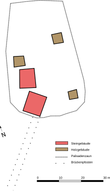
The castle complex is a typical low castle and was protected by the surrounding moor and the lake. Access to the Dannsee was made from the Revenaher side via a stick dam , from which remains were repeatedly found by farmers. Access to important long-distance routes and to Horneburg was given via Revenahe . Beckdorf also had access to the lake through the moor. Both paths met on the south bank of the Dannsee at an approximately 35 meter long wooden bridge, which was the actual entrance to the castle. The 55 × 35 meter castle was surrounded by a circumferential wooden palisade with a battlement , inside which the castle buildings were located. The bridge ended at a 9 × 9 meter gatehouse , which presumably also served as the main building of the castle. Right next to it was another 9 × 7 meter building. Both were massive, brick- lined half-timbered buildings with tiled roofs. Inside the 55 x 35 m castle there were also some wooden outbuildings, probably workshops and stables.
Todays use
After the Beckdorf community bought the property in 2001, Burgplatz was made accessible to the public. After the excavations in 2003, the Burgplatz was redesigned. Stones now mark the outlines of the castle buildings, the bridge was marked with stakes. The course of the picket fence was planted with a hedge. A plaque set up next to the excavation site gives an overview of the castle grounds.
The Burgplatz is a little off the beaten track, on the road between Beckdorf and Wiegersen . The route is signposted from Beckdorf. A diorama of the castle and a replica of a Blide can also be viewed in the Beckdorfer Beekhoff .
literature
- Klaus Bredehöft: Islands in the moor. From the story of Revenahe-Kammerbusch. Kammerbusch 1984.
- Dietrich Alsdorf: Isern Hinnerk - on the trail of a myth in: Archeology in Lower Saxony , 2003, pp. 69–71.
- Dietrich Alsdorf: Dannsee - the castle of "Isern Hinnerk" . Past and present 2004, ed. v. Association for Monastery and Local History Harsefeld e. V., Harsefeld 2004, pp. 24-44.
Web links
- The Kranzbinder Beckdorf eV: The Dann-See castle
- Entry by Stefan Eismann about Burg im Dannsee in the scientific database " EBIDAT " of the European Castle Institute
- Reinhard Dzingel: De ganß grode Schangs - oer de Schatt vun'n Isern Hinnerk , Low German essay on the saga, Moisburg, 2011 (PDF; 938 kB)


